Academia.eduAcademia.edu

Satellite and RADAR Meteorology

description9 papers
group72 followers
lightbulbAbout this topic
Satellite and RADAR Meteorology is the study of atmospheric phenomena using satellite and radar technologies. It involves the collection, analysis, and interpretation of data to monitor weather patterns, track storms, and improve forecasting accuracy, thereby enhancing our understanding of meteorological processes and their impacts on the environment.

Key research themes

1. How have polarimetric radar techniques advanced quantitative precipitation estimation for rain and snow?

This research area focuses on the development, optimization, and operational implementation of polarimetric radar methods for accurate estimation of rainfall and snowfall rates. Accurate QPE is critical for hydrological applications, severe storm warnings, and NWP model assimilation. Understanding the impacts of microphysical variability, such as drop size distribution and hydrometeor phase, and integrating multiple radar observables like differential reflectivity and specific differential phase, are essential to reduce uncertainties in precipitation measurement, especially over different frequency bands and under complex precipitation regimes.

Key finding: This study reviews and summarizes polarimetric radar QPE methods, highlighting that algorithms combining specific attenuation (A), specific differential phase (KDP), and reflectivity (Z) significantly improve rainfall... Read more
Key finding: Using radar and in situ data, this study shows that microphysical processes dominated by drop breakup over coalescence in typhoon precipitation impact polarimetric radar measurements, causing significant deviations in... Read more
Key finding: By combining Doppler polarimetric X-band radar data with geostationary satellite observations, this study demonstrates effective hydrometeor classification and microphysical analysis of convective storms, despite challenges... Read more
Key finding: This work presents the ARM radar network's deployment of multi-frequency (Ka-, W-, X-band) radars with dual- and triple-frequency capability and polarimetric measurements to capture cloud and precipitation life cycles at... Read more

2. How can satellite-based microwave and infrared observations enhance precipitation measurement and assimilation in numerical weather prediction?

This theme investigates methodologies for satellite precipitation estimation using passive microwave (MW) and infrared (IR) sensors in geostationary and polar orbits. It focuses on the synergistic use of multi-instrument and multi-frequency observations for rainfall retrieval, the challenges of vertical structure inference, calibration, and error propagation, and recent algorithmic improvements targeting higher spatial and temporal resolution. These satellites fill coverage gaps over oceans and remote regions, providing essential input for operational meteorology and climate studies, as well as for assimilation into NWP systems.

Key finding: This review comprehensively covers satellite rainfall estimation approaches, emphasizing the complementarity of VIS/IR imagers on geostationary satellites and microwave radiometers on polar orbiters. The study identifies... Read more
Key finding: This paper conducts a detailed error budget analysis of the SCaMPR precipitation retrieval algorithm applied to GOES-R geostationary satellites and its passive microwave calibrator dataset MWCOMB. It quantifies spatial and... Read more
Key finding: The paper describes the strategy for improving satellite microwave rainfall retrieval algorithms within GSMaP by developing physically consistent precipitation models and lookup tables derived from ground radar observations,... Read more
Key finding: This review evaluates existing and planned spaceborne radar missions (e.g., TRMM, CloudSat, GPM, EarthCARE), emphasizing their unique capability to provide vertical structure of clouds and precipitation globally. It... Read more

3. What are the key challenges and solutions in integrating ground-based radar and satellite precipitation data for hydrological and meteorological applications?

This research theme addresses the combination and validation of ground-based weather radar data and satellite observations to achieve improved precipitation measurement accuracy and coverage. It includes studies on assessing radar measurement uncertainties in complex terrain, evaluating consistency between radar and rain gauges, improving rainfall-runoff modeling inputs via radar and satellite data assimilation, and the reconciliation of multi-sensor datasets during extreme weather events. These integrative approaches are vital for hydrological forecasting, severe weather monitoring, and climate impact assessments.

Key finding: This review highlights the high spatial and temporal resolution advantages of weather radar rainfall data for meteorological and hydrological modeling, while systematically discussing radar measurement errors arising from... Read more
Key finding: By comparing dual-polarimetric S-band radar precipitation estimates with a dense network of 30 automatic rain gauges, this study quantifies uncertainties and biases in radar rainfall products over a highly landslide-prone... Read more
Key finding: This work performs a cross-comparison of reflectivity measurements between ground-based NEXRAD radars and the satellite-borne Dual-frequency Precipitation Radar (DPR) onboard GPM during extreme tropical cyclone events over... Read more
Key finding: Focusing on complex terrain around Grenoble, France, this study evaluates radar placement, elevation angle, and vertical reflectivity profile corrections to mitigate dominant radar errors like ground clutter and beam blockage... Read more
Key finding: This paper examines methods for spatially and temporally matching satellite-derived cloud properties with ground-based observations at the ARM SGP site, addressing challenges posed by differing spatial scales and temporal... Read more

All papers in Satellite and RADAR Meteorology

Natural disasters, such as tornadoes and hurricanes, cause massive damage in the USA on a regular basis. Most of the actions taken to limit the damage they cause have been limited to early warning systems and recovery and restoration... more
During the afternoon of 23 October 2022, a mesoscale convective system (MCS) developed and intensified over the English Channel and tracked north-northeastward into southern England, producing widespread damaging winds and at least three... more
The 24 September 2001 College Park, Maryland, tornado was a long-track and strong tornado that passed within a close range of two Doppler radars. It was the third in a series of three tornadoes associated with a supercell storm that... more
A squall line, forced by an approaching cold front, developed across eastern New York State during the afternoon of 21August 2004.
Severe convective storms that produce tornadoes and straight-line winds usually develop under particular environmental conditions and have specific signatures on the cloud tops associated with intense updrafts. In this study, we performed... more
New diagnostic methods are presented for localized, barotropic vorticity evolution in tornadic environments. These methods focus on superhelicity, a quantity shown to be strongly related to local maxima in vorticity tendency. Mobile... more
Recent research pertaining to aerosol impacts on cloud microphysics has shown a need for understanding mineral dust entrainment into moist convection. The goal of this study is to examine the pathways in which nonmicrophysically active... more
Thunderstorm-generated severe winds (i.e., downbursts) are an operational forecasting challenge due to the spectrum of time, space, and intensity scales in which they occur. Recent research efforts have highlighted the ability of NOAA... more
Cold season tornadic outbreaks occur with regularity in the southeastern United States; however, detailed analyses of parent supercell storms in the cold season environment (often low CAPE, high shear) are scarce. This is often because... more
The 24 September 2001 College Park, Maryland, tornado was a long-tracked and violent tornado that passed within a close range of two Doppler radars. It was the third in a series of three tornadoes associated with a supercell storm that... more
The use of radar to diagnose thunderstorm structure and evolution has been going on since the birth of weather radar during and just after World War II. In
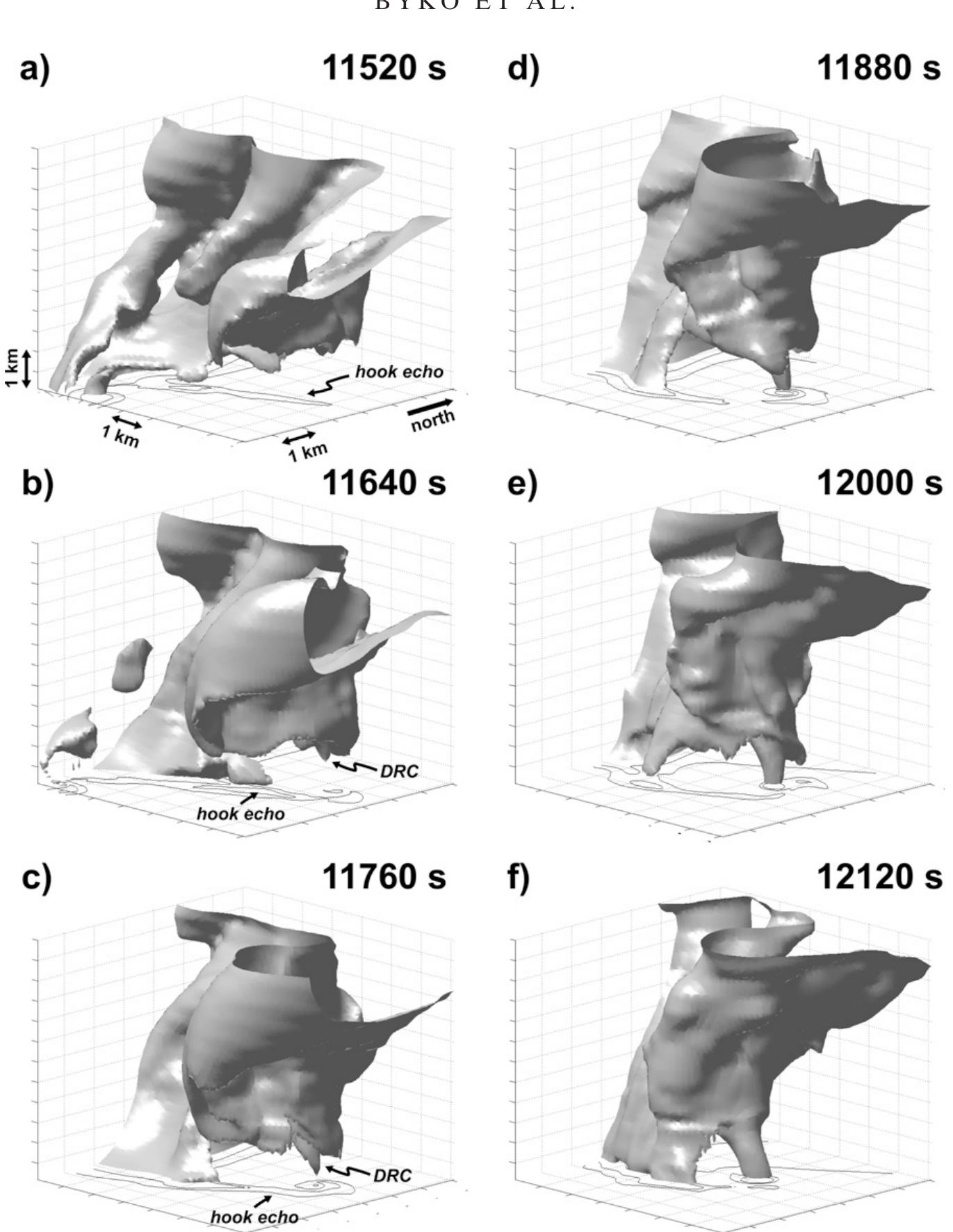
This paper is motivated by the recent interest in the ‘‘descending reflectivity cores’ ’ (DRCs) that have been observed in some supercell thunderstorms prior to the development or intensification of low-level rotation. The DRCs of... more
Accurate and prior identification of local severe storm systems in pre-convection environments using geostationary satellite imagery measurements is a challenging task. Methodologies for “convective initiation” identification have already... more
Cumulus parameterizations in general circulation models (GCMs) frequently apply mass-flux schemes in their description of tropical convection. Mass flux constitutes the product of the fractional area covered by cumulus clouds in a model... more
Motivation and Goals Methodology Data/Weather Cases Results Conclusion/Outlook Evolution of conserved variables related to storm cells during severe convection in a mesoscale model
Vortex lines passing through the low-level mesocyclone regions of six supercell thunderstorms (three nontornadic, three tornadic) are computed from pseudo-dual-Doppler airborne radar observations obtained during the Verification of the... more
Canada is a vast country with most of its population located along its southern border. Large areas are sparsely populated and/or heavily forested, and severe weather reports are rare when thunderstorms occur there. Thus, it has been... more
The 24 September 2001 College Park, Maryland, tornado was a long-tracked and violent tornado that passed within a close range of two Doppler radars. It was the third in a series of three tornadoes associated with a supercell storm that... more
The 24 September 2001 College Park, Maryland, tornado was a long-track and strong tornado that passed within a close range of two Doppler radars. It was the third in a series of three tornadoes associated with a supercell storm that... more
La inminente instalación de un Sistema Nacional de Radares Meteorológicos Doppler polarimétricos (SINARAME) que se agregarán a los ya existentes en el país, plantea la oportunidad de incorporar receptores pasivos de menor costo que... more
Data collected during Project Analysis of the Near-Surface Wind and Environment along the Rear-flank of Supercells (ANSWERS) provided an opportunity to test recently published associations between rearflank downdraft (RFD) thermodynamic... more
Radar structures of one mesocyclone and one mesocirculation (the term mesocirculation refers to a class of rotating updrafts, which may or may not be as spatially and temporally large as a typical mesocyclone) that developed a total of... more
The artificial properties in two dimensional electromagnetic structures (2D-EBGs), such as PMC and Band Reject Region are investigated for a proposed structure of square shaped mushroom. The radiation characteristics of monopole antenna... more
Download research papers for free!