Landslides are a significant hazard in Churachandpur district, Manipur, frequently triggered by heavy rainfall, earthquakes and human activities such as deforestation, shifting cultivation and constructions. The landslides are more...
moreLandslides are a significant hazard in Churachandpur district, Manipur, frequently triggered by heavy rainfall, earthquakes and human activities such as deforestation, shifting cultivation and constructions. The landslides are more prominent along national highway 150 and 102B due to high topography, ranging up to 2,100 metres above sea level. The research used weighted parameter analysis, Remote Sensing (RS) and Geographic Information System (GIS) methodologies to create
a landslide susceptibility map for the study area. High-resolution thematic layers were generated from various data sources, including terrain-corrected data from earthexplorer.usgs.gov (SRTM 30
m resolution), Sentinel-2A multi-spectral satellite imagery (10 m resolution) and LANDSAT 8 satellite data, alongside other relevant factors such as rainfall distribution, slope and structural features
(faults, drainage density, roads).
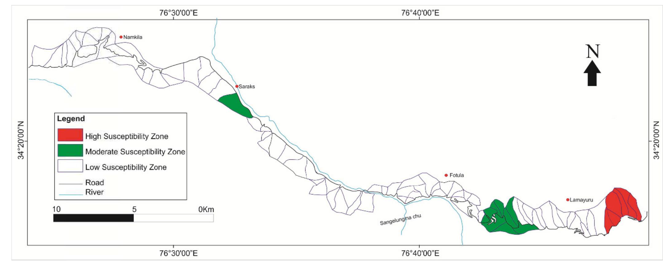
These thematic layers were integrated within a GIS platform (ArcGIS 10.8) to identify zones vulnerable to landslides. A standard weighted overlay technique was employed to assign values ranging from 0 to 10 to different causative factors influencing landslide occurrence. The resulting landslide susceptibility map categorises the study area into three levels: high, medium and low susceptibility. The landslide displacement in high-susceptibility zones highlights significant terrain
movement, ranging from minor soil shifts to large-scale debris flow, disrupting transportation, damaging infrastructure and threatening livelihoods, requiring urgent mitigation measures for regional safety. This research provides valuable insights for regional infrastructure planning,
landslide hazard mitigation and geo-environmental development, ultimately contributing to enhanced safety and sustainable development in the Churachandpur district.
These vulnerable areas are located near major infrastructures and forest lands, so there is a need to have some kind of controls, such as slope stabilization, erosion control, and regulated deforestation, which will help to reduce the incidences of these occurrences. ROC curve analysis
model validation showed very good results (r = 0.89), demonstrating that there is a very good
correlation between the predicted and the observed at landslide event locations. This spatial strategy is an essential instrument for the disaster risk mitigation which is being used to direct the establishment of the sustainable development and resilience strategy in the landslide-prone
mountainous areas like Churachandpur.