Academia.eduAcademia.edu

Joint inversion

description121 papers
group61 followers
lightbulbAbout this topic
Joint inversion is a geophysical data processing technique that simultaneously estimates multiple subsurface properties by integrating different types of geophysical data, such as seismic, electromagnetic, and gravity measurements. This approach enhances the accuracy of subsurface models by leveraging complementary information from various datasets.

Key research themes

1. How can joint inversion methods integrate multiple geophysical datasets to improve subsurface model resolution?

This research area focuses on developing inversion algorithms that jointly interpret different types of geophysical data (e.g., seismic, gravity, electromagnetic) under the assumption of shared subsurface structural features. The goal is to reduce non-uniqueness inherent in individual inversions by exploiting common model boundaries or structural information that links distinct datasets. Advancements here impact fields such as mineral exploration, subsurface characterization, and medical imaging.

Key finding: The authors propose a novel methodology for joint inversion of multiple datasets (e.g., seismic and gravity data) by minimizing a penalized objective function that enforces common structure, defined via model curvature,... Read more
Key finding: This study introduces a subspace approach for simultaneous inversion of seismic amplitude variation with offset (AVO) data to recover P-wave impedance, S-wave impedance, and density. By parameterizing elastic properties with... Read more
Key finding: Through comprehensive arrival-time data inversion, this work compares LSQR and L-BFGS-B optimization algorithms for anisotropic seismic tomography. It finds that both algorithms produce comparable P-wave velocity and... Read more
Key finding: By combining active and passive seismic datasets—specifically Rayleigh and Love wave dispersions and HVSR measurements—the authors develop joint inversion strategies that improve resolution of Vs profiles in industrial sites... Read more
Key finding: This work critically evaluates the MASW approach based on subjective interpretation of Rayleigh wave phase velocity spectra, advocating for a multi-component joint inversion strategy using the Full Velocity Spectrum (FVS)... Read more

2. What are novel algorithmic advances and applications in inverse kinematics for articulated systems?

This theme explores the development of new computational algorithms to solve inverse kinematics (IK) problems efficiently and realistically for articulated joint chains, with applications in robotics, computer graphics, and biomechanics. It includes analysis and improvements over classical methods like Cyclic Coordinate Descent (CCD), focusing on convergence speed, joint motion naturalness, and avoidance of undesirable rotations, which are critical for animation accuracy and robotic control.

Key finding: The paper introduces the triangulation algorithm, a geometric approach using the law of cosines to analytically compute joint angles of kinematic chains from root to end-effector. Compared to CCD, triangulation requires fewer... Read more
Key finding: This study proposes a single-pass inverse kinematics algorithm that rotates each joint at most once, preventing large undesirable joint rotations common in CCD and triangulation methods. The algorithm improves convergence... Read more
Key finding: Addressing speed and precision trade-offs, this work discusses analog computational techniques for fast matrix inversion crucial for robot kinematics, such as 6×6 Jacobians. It argues that lower-precision analog computation,... Read more

3. How can onset time analysis and advanced seismic inversion improve fluid flow characterization in reservoirs?

This research focuses on innovative inversion methods leveraging onset times of seismic attribute changes—rather than magnitudes—to reduce sensitivity to rock physics uncertainties for monitoring fluid flow in subsurface reservoirs. Such approaches provide more robust imaging of saturation and pressure changes in enhanced oil recovery and other fluid injection contexts, enabling improved estimation of flow properties and dynamic characterization from seismic monitoring data.
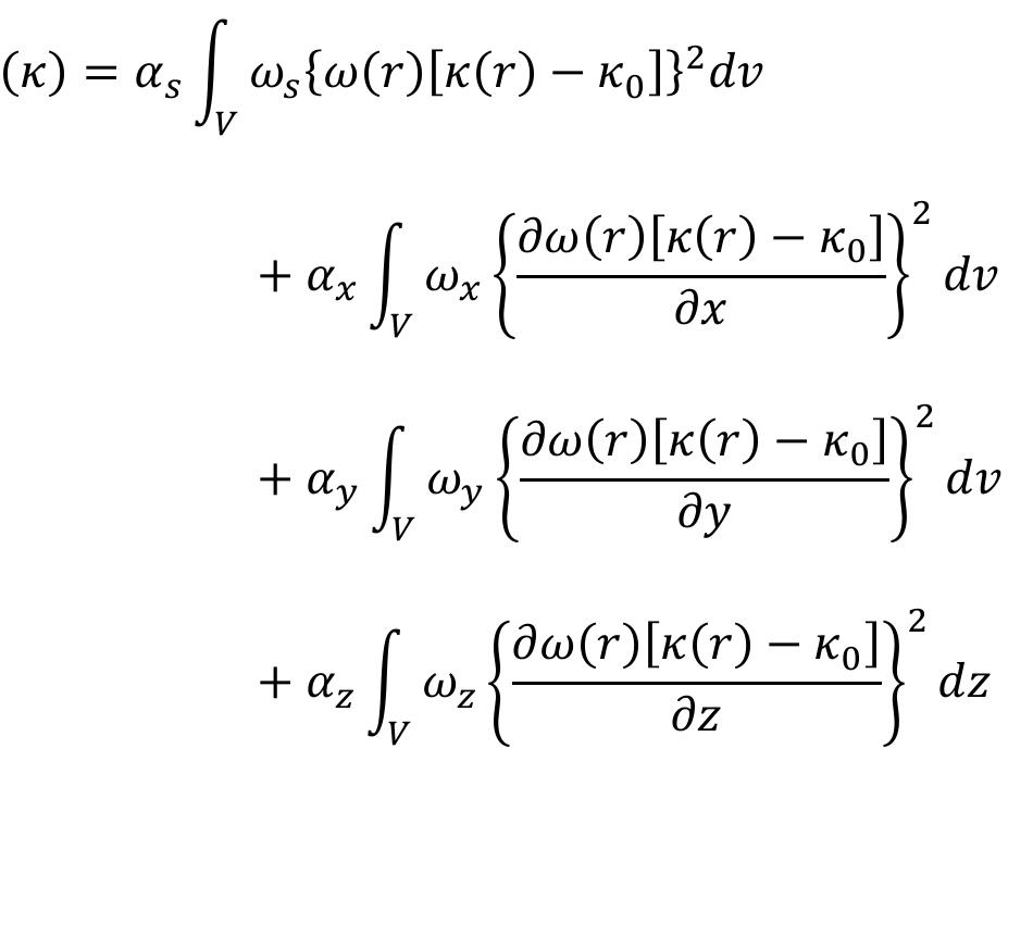
Key finding: The study develops and applies an inversion methodology using onset times derived from frequent time-lapse seismic surveys to characterize fluid flow dynamics in a complex cyclic steam stimulation operation. It demonstrates... Read more

All papers in Joint inversion

Surface-wave analysis can be performed according to a multitude of approaches. In fact, both the determination of the dispersive properties and data inversion can be accomplished according to several possible techniques, which should be... more
The Mw 9.2 Sumatra earthquake of December 26, 2004, like other huge Earthquakes of the past, denotes the difficulty of the science to understand such extended seismic sources. In this work we intended to explain the project SISMOD that... more
The Global Positioning System (GPS) network in Japan detected coseismic deformation from the 2007 Noto Hanto earthquake (M w = 6.9). The result indicates a 21-cm southwestward displacement and a 7-cm upheaval at the GPS site near the... more
The Colorado Plateau is a physiographic province in the western US with an average elevation of $1.9 km where, in contrast to neighboring provinces, there is little evidence of large scale tectonic deformation or magmatism. Recent... more
The thick crust of the southern Tibetan and central Andean plateaus includes high-conductivity, low-velocity zones ascribed to partial melt. The melt origin and effect on plateau uplift remain speculative, in particular if plateau uplift... more
In order to understand the subsurface stratigraphy and structure of the northwest end of the Turkana Basin, Northern Kenya Rift, we used 2-D joint inversion of magnetotelluric (MT) and gravity data acquired along 3 profiles perpendicular... more
Nella Tabella è riportato il gruppo di lavoro del CNR-I.A.M.C. che ha partecipato all'acquisizione dei dati geofisici:
Neste trabalho é apresentada uma metodologia baseada no cruzamento de técnicas e dados sísmicos (ondas de volume com registo telessísmico por estações de banda larga) e geodésicos (SAR-Radar de Abertura Sintética) com o intuito de estudar... more
To define the procedures necessary to unambiguously define the subsurface model, a comprehensive set of active and passive seismic data was collected in an industrial area characterized by an extremely high level of background... more
SUMMARYOur limited knowledge of the relationship between changes in the state of an aquifer or reservoir and the corresponding changes in the elastic moduli, that is the rock physics model, hampers the effective use of time-lapse seismic... more
The Colorado Plateau is a physiographic province in the western US with an average elevation of $1.9 km where, in contrast to neighboring provinces, there is little evidence of large scale tectonic deformation or magmatism. Recent... more
Geometrical properties of an earthquake population can be described by summation of seismic potency tensors that provide a strain-based description of earthquake focal mechanisms. We apply this method to ∼170 000 potency tensors for 0 < M... more
The 12 November 1996 M w 7.7 Peru subduction zone earthquake occurred off the coast of southern Peru, near the intersection of the South American trench and the highest topographical point of the subducting Nazca Ridge. We model the... more
Until recently, little was known about the Weddell Sea sector of the West Antarctic Ice Sheet. In the last 10 years, a variety of expeditions and numerical modelling experiments have improved knowledge of its glaciology, glacial geology... more
We present a joint analysis of newly acquired gravity and teleseismic data in the North Tanzanian Divergence, where the lithospheric break-up is at its earliest stage. The impact of a mantle upwelling in more mature branches of the East... more
HAL is a multidisciplinary open access archive for the deposit and dissemination of scientific research documents, whether they are published or not. The documents may come from teaching and research institutions in France or abroad, or... more
The Central Andes is a key global location to study the enigmatic relation between volcanism and plutonism because it has been the site of large ignim briteforming eruptions during the past several million years and currently hosts the... more
We use seismic and geodetic data both jointly and separately to constrain coseismic slip from the 12 November 1996 Mw 7.7 and 23 June 2001 Mw 8.5 southern Peru subduction zone earthquakes, as well as two large aftershocks following the... more
of southern Peru, near the intersection of the South American trench and the highest topographical point of the subducting Nazca Ridge. We model the broadband teleseismic P-waveforms from stations in the Global Seismic Network to... more
The Central Andes is a key global location to study the enigmatic relation between volcanism and plutonism because it has been the site of large ignim briteforming eruptions during the past several million years and currently hosts the... more
When a nil zone is present in the subsurface salt structure, it effectively creates an annihilator of density contrast that gives rise to zero gravity response on the surface. As a result, part of the salt structure is invisible to the... more
The Nechalacho deposit is a world-class rare earth element deposit located in the Thor Lake region approximately 100 kilometers southwest of Yellowknife, NT, Canada. Located within the Blatchford Lake Intrusion Complex, this deposit has... more
2D and 3D imaging of the metamorphic carbonates at Omalos plateau/polje, Crete, Greece by employing independent and joint inversion on resistivity and seismic data
We present two case studies of the application of seismic surveys to estimate the elastic properties of soil and rock in the shallow subsurface. The two sites present very different geological characteristics. The first test site is a... more
For the seismic and dynamic design of the civil eng ineering projects a significant role is assumed by the geotechnical-seismic characterization of the site. The new Italian seismic code as well as the Eurocod es and other international... more
Surface wave tests are non-invasive seismic techniques that have traditionally been used to determine the shear wave velocity (i.e. shear modulus) profile of soil deposits and pavement systems. Recently, Rix et al. [J. Geotech.... more
High resolution structures of the lithosphere-asthenosphere system beneath a seismic profile in Iran are obtained by the simultaneous inversion of data from receiver functions and fundamental mode Rayleigh wave group velocity and... more
of southern Peru, near the intersection of the South American trench and the highest topographical point of the subducting Nazca Ridge. We model the broadband teleseismic P-waveforms from stations in the Global Seismic Network to... more
SUMMARYOur limited knowledge of the relationship between changes in the state of an aquifer or reservoir and the corresponding changes in the elastic moduli, that is the rock physics model, hampers the effective use of time-lapse seismic... more
In oscillatory shear experiments, the values of the storage and loss moduli, G (ω) and G (ω), respectively, are only measured and recorded for a number of values of the frequency ω in some well-defined finite range [ω min , ω max ]. In... more
The Lazufre Volcanic System (LVS), on the border of northern Chile and Argentina, is an active complex of two volcanoes, Lastarria to the north and Cordón del Azufre to the south. The LVS is not regularly monitored with any scientific... more
We use Interferometric Synthetic Aperture Radar (InSAR), teleseismic body waves, tsunami waveforms recorded by tsunameters, field observations of coastal uplift, subsidence and run-up to develop and test a refined model of the... more
The Lazufre Volcanic System (LVS), on the border of northern Chile and Argentina, is an active complex of two volcanoes, Lastarria to the north and Cordón del Azufre to the south. The LVS is not regularly monitored with any scientific... more
A method for history matching of an in-house petroleum reservoir compositional simulator with multipoint flux approximation is presented. This method is used for the estimation of unknown reservoir parameters, such as permeability and... more
The Altiplano-Puna magma body (APMB) is recognized as one of the largest crustal magma bodies on Earth. Geophysical studies have detected a thin low velocity zone at a depth of about 20 km that is inferred to be a layer of > 20% partial... more
New volcanic unrest has been detected in the Domuyo Volcanic Center (DVC), to the east of the Andes Southern Volcanic Zone in Argentina. To better understand this activity, we investigated new seismic monitoring data, gravimetric and... more
of southern Peru, near the intersection of the South American trench and the highest topographical point of the subducting Nazca Ridge. We model the broadband teleseismic P-waveforms from stations in the Global Seismic Network to... more
The great Rat Islands underthrusting earthquake (Mw = 8.7), of February 4, 1965, represents subduction of the Pacific plate beneath the North American plate along a 600-km segment of the western end of the Aleutian Islands. Body wave... more
In recent years, the use of radiographic inspection with cosmic-ray muons has spread into multiple research and industrial fields. This technique is based on the highpenetration power of cosmogenic muons. Specifically, it allows the... more
Investigations made to evaluate the site-effect characteristics and to develop a reliable site classification scheme have received paramount importance for the urban areas planning and reliable sitespecific seismic hazard assessment. This... more
Rayleigh wave or ground roll is a noise in seismic body waves. However, how to use this noise for soil characterization is very interesting since Rayleigh wave phase velocity is a function of compression-wave velocity, shearwave velocity,... more
Tsunamis from the 2004 off the Kii Peninsula earthquakes (M 7.1 and 7.4) were recorded on offshore tsunami gauges, a GPS tsunami gauge and eight bottom-pressure gauges, as well as coastal tide gauges located south of Honshu and Shikoku.... more
Tsunami earthquakes are a group of enigmatic earthquakes generating disproportionally large tsunamis relative to seismic magnitude. These events occur most typically near deep-sea trenches. Tsunami earthquakes occurring approximately... more
Tsunamis from the 2004 off the Kii Peninsula earthquakes (M 7.1 and 7.4) were recorded on offshore tsunami gauges, a GPS tsunami gauge and eight bottom-pressure gauges, as well as coastal tide gauges located south of Honshu and Shikoku.... more
We use seismic and geodetic data both jointly and separately to constrain coseismic slip from the 12 November 1996 M w 7.7 and 23 June 2001 M w 8.5 southern Peru subduction zone earthquakes, as well as two large aftershocks following the... more
Download research papers for free!