Videos by Giancarlo Dal Moro
"Tools for the efficient analysis of surface waves from active and passive seismic data: explorin... more "Tools for the efficient analysis of surface waves from active and passive seismic data: exploring an NE‑Italy perilagoon area with significant lateral variations" (Dal Moro G. and Stemberk J.)
Earth, Planets and Space (2022) 74:140
https://doi.org/10.1186/s40623-022-01698-z
KEYWORDS: Shear-wave velocity (Vs), Surface waves, Group velocities, Phase velocities, Joint Inversion, Full Velocity Spectrum (FVS) analysis, Rayleigh waves, Love waves, Rayleigh-wave Particle Motion (RPM), Multichannel analysis of surface waves (MASW), Holistic analysis of Surface waves (HS), Horizontal-to-Vertical Spectral Ratio (HVSR), NE Italy perilagoonal dune system, Peats, Paleodunes 6 views
Papers by Giancarlo Dal Moro
Pure and Applied Geophysics, 2025
Surface-wave analysis can be performed according to a multitude of approaches. In fact, both the ... more Surface-wave analysis can be performed according to a multitude of approaches. In fact, both the determination of the dispersive properties and data inversion can be accomplished according to several possible techniques, which should be chosen on a case-by-case basis, depending on the goals and site characteristics. The Miniature Array Analysis of Microtremors (MAAM) is an interesting methodology aimed at extracting the dispersive properties of the vertical (Z) component of Rayleigh waves from passive data recorded according to a circular-symmetry array. Compared to other techniques, MAAM can investigate larger wavelengths and provide phase velocities in a wider frequency range (a triangular array with a radius of a couple of meters can provide the dispersion curve in the 2-20 Hz frequency range, approximatively). Despite its remarkable potential, MAAM can be affected by industrial noise that alters the natural microtremor field. The comparative analysis of the Z-component dispersion retrieved via Extended Spatial AutoCorrelation (ESAC) and MAAM is initially conducted to validate the adopted procedures and verify the paradigms to adopt to identify the frequency range properly investigated. Following this, analysing a second time-lapse dataset, the effects of industrial components on both the dispersion curve obtained via MAAM and the Horizontal-to-Vertical Spectral Ratio (HVSR) are investigated. The experimental evidences show that non-monochromatic industrial components can have a malicious effect on both MAAM and HVSR. In this context, analysing the coherence functions of the multi-component data recorded by a 3-component geophone, together with the spectral ratio and noise-to-signal ratio obtained during MAAM processing, is crucial for assessing the possible presence of industrial components that may affect the observables ultimately used in the joint inversion.
Some Final Notes
In this final chapter, we will consider few further facts useful to master surface-wave analysis ... more In this final chapter, we will consider few further facts useful to master surface-wave analysis and have a final holistic overview on the main topics and evidences illustrated in the previous chapters, thus being able to properly plan a survey and analyze the data in a way to obtain a robust and consistent subsurface model not affected or biased by misinterpretations or ambiguities.
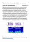
Microtremor data acquired in the city center of Spoleto
The microtremor dataset (20 min record length) was acquired in the city center of Spoleto (centra... more The microtremor dataset (20 min record length) was acquired in the city center of Spoleto (central Italy). Time lapse video contains animation of a multiple-peak HVSR (Horizontal to Vertical Spectral Ratio curve) from microtremor data (20 min record length)
Understanding Surface-Wave Phenomenology
Elsevier eBooks, 2015
Surface waves propagate according to several modes and the dominating ones depends both on the si... more Surface waves propagate according to several modes and the dominating ones depends both on the site (the local stratigraphy), the acquisition geometry (i.e., the distance between source and receiver(s), and the considered components (Rayleigh waves have both a vertical and a radial component) and source. The way modes interlace and manifest in the velocity spectra can be extremely complex and even counterintuitive. This chapter aims at giving some evidence of such a complexity thus also suggesting possible alternative approaches for both acquisition and analysis procedures. The most appropriate solution for a given site will depend on both the specific stratigraphic characteristics and both on the goals of the survey.
Integrated non-invasive characterization of waste disposal sites
Non-invasive characterization of waste disposal and contaminated sites provides large amounts of ... more Non-invasive characterization of waste disposal and contaminated sites provides large amounts of subsurface information at low cost and is a highly desirable approach for site management.

Optimizing the Geotechnical Exploration of Vast Areas via Joint Multi-Component Surface-Wave Velocity Spectra Analysis
Proceedings, Jun 1, 2015
Surface wave analysis is nowadays routinely adopted for the exploration of large areas from the g... more Surface wave analysis is nowadays routinely adopted for the exploration of large areas from the geotechnical point of view. This is usually accomplished by inverting the modal dispersion curves of successive shot gathers, therefore depicting the 2D subsurface structures in terms of shear-wave velocities. Such a classical approach (typically performed while uniquely considering the vertical component of Rayleigh waves) can result heavy (hundreds or thousands of velocity spectra to interpret and pick) and, in case of complex phase-velocity spectra, analyses can result inaccurate and biased by personal and potentially erroneous interpretations. In the present work are presented some preliminary results of the implementation of a system (acquisition and processing procedures) aimed at determining 2D Vs sections following an unconventional approach. Data are acquired possibly according to a multi-component procedure, initially analyzed in relative terms to quickly put in evidence possible lateral variations and eventually (jointly) inverted to retrieve a robust 2D subsurface Vs structure. Multi-component data acquisition is performed by considering the vertical component of Rayleigh waves and Love waves, while their joint inversion is performed according to the Full Velocity Spectra (FVS) approach, taking advantage of a highly-automated (though computationally intensive) process capable of better handling complex velocity spectra.
Multifold ground-penetrating radar and resistivity to study the stratigraphy of shallow unconsolidated sediments
The leading edge, Sep 1, 2003
Reconstruction of shallow stratigraphy of unconsolidated sediments is a topic of primary interest... more Reconstruction of shallow stratigraphy of unconsolidated sediments is a topic of primary interest in several environmental, hydrological, geotechnical, and engineering applications. The identification of porous layers and the assessment of their saturation, the characterization of sediments, the identification of bedrock and the analysis of shallow layering are some examples of topics of primary interest in near-surface applications. Recent ground-penetrating radar (GPR) research demonstrates the excellent results that can be attained in the study of shallow stratigraphy. Complex stratigraphic structures, involving cross-stratification, conflicting dips, and rapid lateral and vertical particle-size variations pose a challenge to the application of single-fold (constant offset) GPR methods. The objectives of the present work are imaging and resolution enhancement of GPR multifold records from shallow, unconsolidated sediments. The study is based, in particular, on prestack processing and imaging of data from alluvial plain sites in northern Italy, which are characterized by different stratigraphic and sedimentological conditions. Figure 1 shows the location map of the survey. We show the results obtained on a fluvial terrace of the Isonzo River that are characterized by a complete alluvial sequence including a range of sediments (gravel to clayey loam) and range of stratigraphic structures (depositional and erosional). The water table and vadose zone are in the GPR and resistivity depth range and affect the response of the geophysical techniques, particularly the lateral and vertical resistivity and GPR velocity variations. Figure 1. Map and aerial picture of the study area. The red rectangle shows the location of the 20 × 12 m study area. The site is close to the riverbank, where the different stratigraphic units identified by the geophysical survey were identified and sampled. A Mala Geoscience GPR system was equipped with shielded 250-MHz antennae for the study. Single-fold methods were used in reconnaissance surveys at all test sites. We successively performed …
Insights on surface wave dispersion and H/V curves: joint inversion via Pareto optimality
Integrated GPR and Geo-Resistivity Study of Shallow Stratigraphy in Sandy Coastal Environments
A025 INTEGRATED GPR AND RESISTIVITY STUDY OF SHALLOW STRATIGRAPHY IN SANDY COASTAL ENVIRONMENTS A... more A025 INTEGRATED GPR AND RESISTIVITY STUDY OF SHALLOW STRATIGRAPHY IN SANDY COASTAL ENVIRONMENTS Abstract 1 We performed an integrated Multi-Fold GPR and resistivity survey in a coastal area in the northern part of Italy (Adriatic coast) to reconstruct 3D stratigraphy to localize vadose zone and water table and to identify possible man-made structures and excavations. The spatial sampling was sufficiently dense to perform 3-D interpretation of radar data and 2.5-D reconstruction of iso-resistivity surfaces across the grid. Processing of GPR Single and Multi Fold data focused on true amplitude signal recovery in order to preserve information related to electromagnetic impedance
Multi-Frequency and Multi-Azimuth Polarimetric GPR for Buried Utilities Detection
65th EAGE Conference & Exhibition, 2003
P091 MULTI-FREQUENCY AND MULTI-AZIMUTH POLARIMETRIC GPR FOR BURIED UTILITIES DETECTION Abstract 1... more P091 MULTI-FREQUENCY AND MULTI-AZIMUTH POLARIMETRIC GPR FOR BURIED UTILITIES DETECTION Abstract 1 We exploit multi-frequency and multi-azimuth polarimetric GPR techniques to detect and characterize linear targets for the study of urban technological networks. The selected targets are buried pipes of different materials and the GPR measurements are performed in TE and TM co-pole antenna configurations. We test the methods in controlled (sandbox) and in real conditions. We further compare Finite Difference Time Domain (FDTD) numerical simulations with real data obtained from the sandbox in order to estimate the electromagnetic (EM) properties of the target (pipe). Azimuthal surveys performed in co-pole
Interpretive Migration Velocity Analysis with Applications to GPR
EAGE/SEG Summer Research Workshop - Processing and imaging of seismic data, 2003
Velocity model refinement by a combination of Deregowsky and focusing techniques is an effective ... more Velocity model refinement by a combination of Deregowsky and focusing techniques is an effective solution to image complex shallow subsurface conditions by means of GPR. Including geological knowledge in the velocity analysis of CRP gather considerably reduces costs and uncertainties of the final velocity model and allows rapid convergence to the correct solution. Applications to high resolution GPR study of alluvial sediments confirm the accuracy of the results attainable by PSDM in imaging complex sedimentological patterns.
The Use of 4D Seismic for Ocean Acoustic Tomography
Theoretical and Computational Acoustics 2001, 2002

We exploit a combination of transmission and reflection Ground Penetrating Radar (GPR) techniques... more We exploit a combination of transmission and reflection Ground Penetrating Radar (GPR) techniques to characterize limestone at different scales (from sub-metric/metric to decametric). The integrated method is based on Multi-Fold (MF) GPR techniques to obtain radar response at different offsets (source-receiver separation) corresponding to different incidence angles. MF GPR measurements are combined with transmission tomography where possible (isolated blocks). The MF datasets allow imaging of rock conditions, characterization of rock, fractures and filling materials. Imaging of joints, fractures, voids and heterogeneous volumes is performed by means of pre-stack and post-stack time and depth imaging methods. In this work experiments are carried out from the surface or on isolated blocks using a pulse GPR system equipped with 250, 500 and 800 MHz central frequencies antennas. The results show that the integrated multi-fold/tomographic method allows enhanced characterization of limestone, compared with conventional sonic methods and proves to be highly sensitive to subtle variations in the lithological and physical properties of the rock mass.
Joint Inversion of Seismic Data by Means of Multi-objective Evolutionary Algorithms
70th EAGE Conference and Exhibition incorporating SPE EUROPEC 2008, 2008
Any sort of data is able to cast light only onto a specific aspect of the investigated problem. T... more Any sort of data is able to cast light only onto a specific aspect of the investigated problem. The implementation of a joint inversion scheme is meant to proficiently integrate the information that can be extracted from one dataset with those coming from another one. If the two objectives depend upon the same variables we can obtain a better-focused solution, while if the two objectives pertain (even just partially) to different variables thus their joint use can lead to new considerations characterized by a higher so-to-speak added value. The proposed computational scheme allows the joint inversion of non-commensurable datasets by means of analysis of the Pareto front performed in the framework of a Multi-Objective Evolutionary Algorithm (MOEA). The adopted approach also allows the validation of the provisional interpretation. In fact, Pareto front symmetry proves to be a valuable tool to verify the coherency of the adopted interpretation as an incorrect number of layers, reflector/refractor attribution or assumed Poisson values determine non-symmetric Pareto front as well as a wider model distribution in the objective space.

Geophysics, 2024
To define the procedures necessary to unambiguously define the subsurface model, a comprehensive ... more To define the procedures necessary to unambiguously define the subsurface model, a comprehensive set of active and passive seismic data was collected in an industrial area characterized by an extremely high level of background microtremors. Passive data are recorded to define three observables: the dispersion curve of the vertical component of Rayleigh waves via miniature array analysis of microtremors, the Love-wave dispersion curve via extended spatial autocorrelation, and the horizontal-to-vertical spectral ratio (HVSR). Active data used for the holistic analysis of surface waves are extracted from data recorded through a hybrid acquisition procedure accomplished with only two 3C geophones used to simultaneously define the HVSR at two points. Defined observables are combined according to three different approaches: the joint analysis of Rayleigh waves and HVSR, the joint analysis of Rayleigh and Love waves together with the HVSR, and the joint analysis of multicomponent group velocities together with the HVSR and Rayleigh-wave particle motion (RPM) curves. In agreement with the theory, data indicate that, in general, surface-wave modeling cannot be performed considering modal dispersion curves: dispersion obtained from passive data needs to be modeled considering the effective curve, whereas group velocity obtained from active data can be analyzed using the full velocity spectrum technique. Results indicate that joint inversion of Rayleigh-wave dispersion and HVSR does not necessarily ensure the correctness of the obtained S-wave velocity (𝑉s) profile and that Love waves represent a key observable to fully constrain an unambiguous inversion procedure. However, the joint analysis of multicomponent group velocity spectra (from active multicomponent single-offset data) together with the HVSR and RPM curves is a further efficient way to obtain robust 𝑉s profiles through the active and passive data obtained by a single 3C geophone.
We use an integration of Single Fold (SF), Multi fold (MF), i.e. multi offset, Multi Azimuth (MA)... more We use an integration of Single Fold (SF), Multi fold (MF), i.e. multi offset, Multi Azimuth (MA) and Multi Component (MC) or Polarimetric Ground Penetrating Radar (GPR) configurations to identify, characterize and classify targets of environmental interest. The results obtained in real and controlled conditions are validated by numerical simulations and excavation and show that MF/MA/MC GPR methods are fit for target classification in complex subsurface conditions.
MASW? A critical perspective on problems and opportunities in surface-wave analysis from active and passive data (with few legal considerations)
Physics and Chemistry of the Earth, Parts A/B/C
In the last two decades, surface wave analysis has become a widespread practice for several geote... more In the last two decades, surface wave analysis has become a widespread practice for several geotechnical applications and the MASW (Multichannel Analysis of Surface Waves) acronym has become extremely popular. The standard MASW approach is based on the personal (i.e. subjective) interpretation of the phase-velocity spectrum of the vertical component of Rayleigh waves. This way, we do not invert the actual datum but a subjective interpretation that can be wrong and lead to erroneous shear-wave velocity (Vs) profiles. Even in case data interpretation is correct, non-uniqueness of the solution obtained from inversion of just one observable remains a problem. A series of active and passive synthetic and field datasets are used to illustrate main issues in surface wave analysis and highlight the need for multi-component analysis possibly according to an approach that goes beyond the subjective interpretation of modal dispersion curves. The multi-component approach considered to overcome the ambiguities of single-component analysis is performed according to the FVS (Full Velocity Spectrum) approach, therefore overcoming subjective velocity-spectra interpretations. It is also shown that surface-wave analysis can be effectively carried out considering not phase velocities but group velocities, with the obvious benefit that while for the phase-velocity analysis multi-offset data are necessary, the definition of the group velocities can be accomplished from single-offset data (i.e. from the data of one single sensor). An example of erroneous Vs determination made for an important public building is illustrated in order to highlight the importance of multi-component analysis and the need for stricter guidelines.
Dissemination data from the book "Efficient Joint Analysis of Surface Waves and Introduction to Vibration Analysis: Beyond the Clichés" (Dal Moro Giancarlo, 2020), Springer, ISBN 978-3-030-46302-1
The "Data_Dissemination_Efficient_Surface_Waves_Vibrations_Springer2020_Dal_Moro.rar" a... more The "Data_Dissemination_Efficient_Surface_Waves_Vibrations_Springer2020_Dal_Moro.rar" archive contains a series of datasets presented and analyzed in the book "Efficient Joint Analysis of Surface Waves and Introduction to Vibration Analysis: Beyond the Clichés " (Dal Moro Giancarlo, 2020 - Springer [https://www.springer.com/gp/book/9783030463021]).<br><br>For each dataset, details are provided in the specific subfolder.<br><br>

Uploads
Videos by Giancarlo Dal Moro
Earth, Planets and Space (2022) 74:140
https://doi.org/10.1186/s40623-022-01698-z
KEYWORDS: Shear-wave velocity (Vs), Surface waves, Group velocities, Phase velocities, Joint Inversion, Full Velocity Spectrum (FVS) analysis, Rayleigh waves, Love waves, Rayleigh-wave Particle Motion (RPM), Multichannel analysis of surface waves (MASW), Holistic analysis of Surface waves (HS), Horizontal-to-Vertical Spectral Ratio (HVSR), NE Italy perilagoonal dune system, Peats, Paleodunes
Papers by Giancarlo Dal Moro