Academia.eduAcademia.edu

Surveying and Mapping

description210 papers
group7,946 followers
lightbulbAbout this topic
Surveying and Mapping is the science and technique of determining the terrestrial or three-dimensional positions of points and the distances and angles between them. It involves the collection, analysis, and interpretation of spatial data to create accurate representations of the Earth's surface for various applications, including land use planning, construction, and resource management.

Key research themes

1. How can UAV and drone technologies improve the efficiency and accuracy of surveying and mapping in diverse environments?

This research theme investigates the integration of Unmanned Aerial Vehicles (UAVs), drones, and associated photogrammetric and GIS technologies to enhance cadastral, topographic, construction, and wildlife surveys. It matters because traditional surveying methods can be time-consuming, costly, and limited by accessibility, whereas UAVs offer flexible, high-resolution data collection with potential for automation and improved accuracy.

Key finding: Demonstrated that budget UAV systems equipped with photogrammetric software can generate high-resolution digital elevation models sufficient for cadastral and construction surveying, offering a cost-effective alternative to... Read more
Key finding: Developed and tested a UAV-based methodology to map customary land boundaries in rural Namibia, concluding that UAVs can overcome the slow, expensive, and labor-intensive nature of conventional ground surveying. The approach... Read more
Key finding: Presented a drone-based, machine learning-enabled workflow that automatically detects, counts, and measures individual pinnipeds (harbour seals) with 95-97% accuracy. The method outperformed traditional ground counts in... Read more

2. What are the methodological advances and challenges in integrating historical cartographic data with modern GIS and remote sensing for long-term land use and cultural mapping?

This research theme explores the use of historical maps alongside modern geographic information systems (GIS), remote sensing, and digitization techniques to reconstruct past landscapes, assess data uncertainty, and preserve cultural heritage. It is significant for understanding land use changes over time and for ensuring the reliability of historical data interpretation in contemporary spatial analyses.

Key finding: Applied GIS methodologies to compare 19th-century British hydrographic surveys with modern cartography, revealing the high precision of British surveys despite challenging environmental conditions. The integration of... Read more
Key finding: Utilized detailed topographic surveys and GIS analyses alongside urban planning data to model land reallocation ensuring equitable parcel redistribution in Kabuye Phase II. The study successfully integrated historical plot... Read more
Key finding: Provided a detailed graphical and GIS-based reassessment of Egloffstein's 1858 Grand Canyon map, demonstrating its reasonable accuracy in physiographic depiction given observational limitations. The study contextualized... Read more

3. How is the democratization of cartography through web-based tools transforming geographic literacy and participatory mapping?

This theme investigates the emergence of free and accessible online mapping tools such as Google Maps, MyMaps, and Earth Pro, which enable broader public engagement in cartographic processes. These technologies impact geographic media literacy by lowering technical barriers and allowing community-driven mapping initiatives, influencing education, cultural cartography, and land rights documentation.
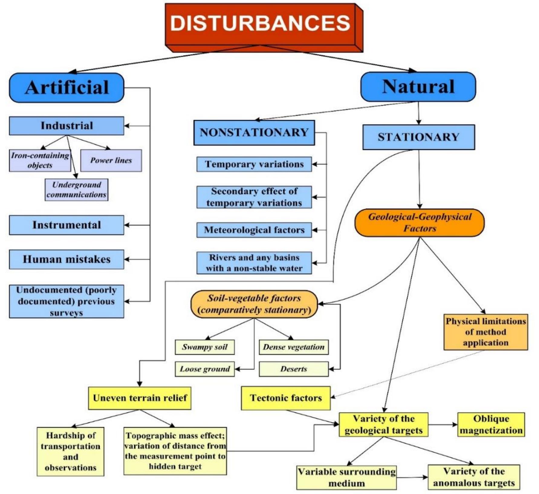
Key finding: Introduced a participatory mapping methodology combining paper-based sketch mapping on printed satellite imagery with automated digitization software to efficiently record and extract parcel boundaries and labels from... Read more
Key finding: Outlined an instructional framework for leveraging free Google applications (Google MyMaps, Earth Pro, Sites) to enable non-expert users to create and publish digital maps as a means to promote geographic media literacy. It... Read more
Key finding: Developed a decolonial, Indigenous-led mapping methodology emphasizing Indigenous temporality, governance structures, and embodied knowledge through walking as a form of map-making. The research challenges Western... Read more

All papers in Surveying and Mapping

Computer application had been a tremendous asset to a construction company since information technology raised rapidly in the era of digital. Computer provide a clean sweep in surveying field by doing design, running analysis, and compute... more
This article assessed the effectiveness of research project supervision in Tanzanian secondary schools from three northern Tanzanian regions: Kilimanjaro, Arusha, and Manyara. A mixed-methods approach was used, incorporating both... more
Land use is an essential component for many areas, from water management to agriculture, from the fight against desertification to that against climate change. Detection changes in land cover allows a better understanding of the state and... more
The dependency of ground water is rising day by day. The ground water gets recharged mainly through rainfall. Thirty five water samples were collected from Parambikulam Aliyar Palar basin from open wells, bore wells and dug cum bore wells... more
The Recorrido Arqueológico de Coixtlahuaca (RAC) presents period-by-period settlement pattern maps for the valley of Coixtlahuaca in the northern Mixteca Alta. The RAC project made improvements in full-coverage survey methods. We identify... more
This collective paper presented at the 44rd International Symposium of Excavation, Research and Archaeometry includes the second season results of the archaeological surveys, which is a part of the new period of researches initiated in... more
Groundwater is a critical resource for drinking and irrigation, yet its quality in rural areas such as Motipur block, Muzaffarpur (Bihar), remains poorly characterized. This study evaluated groundwater suitability by analyzing 40 samples... more
Reconstruction of 3D, especially on height extraction using digital aerial photos taken from a non-metric camera and Unmanned Aerial Vehicle (UAV) is a challenging study. The purposes of this study are: (1) to determine the precision of... more
Pengamatan pola arus laut merupakan bagian dari pengumpulan data yang dilaksanakan oleh Pushidros TNI-AL. Informasi mengenai pola arus digunakan sebagai pendukung untuk keselamatan bernavigasi dalam pelayaran terutama bagi kapal yang akan... more
Noise has been recognized as the air pollutant since it affects the environmental quality. Its effect depends on its level; it may be slightly uncomfortable or so annoying that hinder our business or in extreme cases dangerous to health.... more
In early January 1858, at Fort Yuma, California, Prussian baron Friedrich Wilhelm von Egloffstein joined an exploring expedition under the command of Lt. Joseph Christmas Ives. Their objective was to map the Colorado River and locate its... more
Detecting changes in population trends depends on the accuracy of estimated mean population growth rates and thus the quality of input data. However, monitoring wildlife populations poses economic and logistic challenges especially in... more
Koordinat Geometride Küçük nokta uygulamaları
Ortogonal yöntemle ölçülen detayların koordinatlarının hesaplanmasında kullanılan bir hesap yöntemidir. Bu ölçü yönteminde çift beşgen (double pentagon) prizma kullanıldığı için bu yönteme prizmatik ölçü yöntemi de denir. Bu ölçü... more
Normal bir geriden kestirmeden farklı olarak, doğrultu gözlemleri yerine uzaklıkların ölçülmesiyle yapılan geriden kestirme uygulamasının analizi.
Çift Nokta Geriden Kestirme Yönteminin Teorik ve Uygulamalı İncelenmesi Geriden kestirme, harita mühendisliğinde sıklıkla kullanılan konum belirleme yöntemlerinden biridir. Ancak, bazen arazide yeterli sayıda kontrol noktası... more
The objectives of this paper are to (i) review the diversity and distribution of butterflies in different forested areas of Johor and (ii) compare the species composition in each study site. Data is based on field sampling and published... more
Surveying is a technical work. Those person who've interest in surveying, this special note help him to acquire elementary knowledge of Survey.
Geriden Kestirme: Teorik Temeller ve Çözüm Yöntemleri Özet Geriden kestirme, jeodezik ve haritacılık alanlarında sıklıkla kullanılan bir yöntem olup, bilinmeyen bir noktanın koordinatlarını belirlemek için, koordinatları bilinen en az... more
Democratization * This essay and website promote the democratization of cartography by offering a guide to free Google Mapping and web publishing resources. Tools * This guide presents applications, skills, and tips and tricks to speed up... more
KUTUPSAL KOORDİNAT HESAPLARINDA YÖNTEM VE UYGULAMALAR Özet Kutupsal ölçü yöntemi, haritacılıkta en yaygın kullanılan ölçüm yöntemlerinden biridir. Günümüzde, gelişmiş elektronik ölçüm cihazlarının kullanılmasıyla birlikte bu yöntem daha... more
There has been an emerging shift by Indigenous geographers and non-Indigenous researchers to integrate decolonial methodologies into research protocols to challenge the Western Cartesian production of geographic knowledge across Native... more
This open access edition has been made available under a CC BY-NC-ND 4.0 license thanks to the support of Knowledge Unlatched.
The Deadman's Island (8SR782) and Town Point (8SR983) shipwrecks are unidentified vessel remains that were archaeologically investigated and interpreted as small stripped and abandoned vessels from the British Occupational Period of... more
SURVEYING AND LEVELLING LAB MANUAL BY AK.MD MUBARAK AND Dr.M.SEETHAPATHI
Through the establishment of the Coordination Group for the City of Zagreb Spatial Management IT System, the City of Zagreb has become actively involved in the wider global community by setting up the Zagreb Spatial Data Infrastructure... more
Der Workshop Geklebte Topografien widmet sich Operationen des Klebens, die bei der Herstellung und Verwendung topografischer Bildmedien zum Einsatz kommen-vom Leimen bis zum digitalen Copy and Paste. Medial erzeugte Vorstellungen von Raum... more
Surveying :-is the art of determining the relative position of distinctive features on the surface of the earth or under the surface of the earth by means of measurement of distances ,directions and elevations objective of surveying The... more
Indonesia merupakan Negara kepulauan dengan luas perairan 5,8 juta km2, yang terdiri atas luas perairan kepulauan dan laut territorial sebesar 3,1 juta km2 dan luas Zona Ekonomi Eksklusif (ZEE) sebesar 2,7 km2, serta memiliki garis pantai... more
This work is licensed under Creative Commons Attribution 4.0 License GJES.MS.ID.000759. Introduction Unmanned aerial vehicles (UAVs), also referred to as drones, equipped with various kinds of advanced detecting or surveying systems, are... more
This project focuses on heightening a control at the Nsuta junction (BM2), Tarkwa using the differential leveling technique starting from a known station at the University of Mines and Technology gate (PS1) with a reduced level of 70.92m.... more
Detta examensarbete är fokuserad på undersökningen av RUFRIS noggrannhet relativt till både Sveriges riksnät och traditionella statiska GNSS-mätningar. Dessutom undersöktes antalet bakåtobjekt som krävs för att uppnå godkända etableringar... more
Geodetic reference systems and their realization at the territory of Serbia have been created and maintained since the end of 19th century. Until mid-80s a series of reference geodetic networks were established: trigonometric networks in... more
L’articolo presenta le attività che il Dipartimento di Lettere e Beni Culturali dell’Univer- sità degli Studi della Campania “Luigi Vanvitelli” svolge, ormai da anni, nel monitoraggio delle performance e delle attività dei musei della... more
Includes types of curves, basic definitions, elements of simple curve and method of setting out
U ovom radu dan je pregled izrade i vođenja katastra nekretnina u Republici Srbiji. Država je prepoznala da je učinkoviti nacionalni sustav uknjižbe vlasničkih prava preduvjet za ekonomski rast i širenje gospodarskog prosperiteta...
This collective paper presented at the 43rd International Symposium of Excavation, Research and Archaeometry includes the first season results of the archaeological surveys, which is a part of the new period of researches initiated in... more
With the rapid development of aeromagnetic (primarily uncrewed) methods for measuring Volume 10, Issue 2, 333-370. field studies in the area around the Saatly superdeep borehole (Middle Kur depression between the Greater and Lesser... more
pembahasan fotogrametri dan penginderaan jauh Foto grametri didefinisikan sebagai seni ilmu dan teknologi untuk memperoleh informasi terpercaya tentang objek fisik dan lingkungan melalui proses rekaman pengukuran dan interpretasi gambaran... more
Approximately 4 of 10 Medicaid beneficiaries younger than 21 years did not receive any recommended screenings in fiscal year 2017, according to a recent US Government Accountability Office (GAO) report. Medicaid's Early and Periodic... more
The dependency of ground water is rising day by day. The ground water gets recharged mainly through rainfall. Thirty five water samples were collected from Parambikulam Aliyar Palar basin from open wells, bore wells and dug cum bore wells... more
The land use and land cover change of an area is an outcome of natural and socioeconomic aspects and their operation by humans in time and space (Lambin et al., 2003). Land-use change is a matter of historical process in relation to how... more
The land is required for the development of basic public infrastructure. Compensation for current rights holders of such land must be negotiated. Also, the resulting subdivisions will thus be smaller than the original portions of land,... more
Download research papers for free!