 Don Burn
580 California St., Suite 400
San Francisco, CA, 94104
Academia.edu no longer supports Internet Explorer.
To browse Academia.edu and the wider internet faster and more securely, please take a few seconds to upgrade your browser.
2002, Journal of Hydrology
https://doi.org/10.1016/S0022-1694(01)00514-5…
16 pages
1 file
This paper describes the development and application of a procedure that identi®es trends in hydrologic variables. The procedure utilizes the Mann±Kendall non-parametric test to detect trends, a permutation approach to estimate the test distribution, and accounts for the correlation structure in the data in determining the signi®cance level of the test results. The research investigates 18 hydrologic variables that re¯ect different parts of the hydrologic cycle. The hydrologic variables are analyzed for a network of 248 Canadian catchments that are considered to re¯ect natural conditions. A selection of catchments identi®ed to have trends in hydrologic variables is studied further to investigate the presence of trends in meteorological variables and the relationship between the hydrologic and the meteorological response to climatic change. It is concluded that a greater number of trends are observed than are expected to occur by chance. There are differences in the geographic location of signi®cant trends in the hydrologic variables investigated implying that impacts are not spatially uniform. q


Canadian Water Resources Journal, 2004
A study of trends and variability of hydrological variables was conducted for natural streamflow gauging stations within two watersheds that are important sources of flow within the Mackenzie River Basin. A comparison was made between trend results for the Liard River Basin and for the Athabasca River Basin. These basins represent a north-south transect of high elevation headwater basins within the Mackenzie River system and are significant since they produce 34% of the annual flow, while occupying only 24% of the total drainage area. Trend analysis was conducted using the Mann-Kendall test with an approach that corrects for serial correlation. The global (or field) significance of the results for each watershed was evaluated using a bootstrap resampling approach. The relationships between trends in hydrological variables and trends in meteorological variables were investigated using partial correlation analysis. The results reveal more trends in some hydrological variables than are expected to occur by chance. In general, both basins exhibit an increase in winter flows and some increase in spring runoff. These increased flows are somewhat offset by decreases (not field significant) in summertime flow. Almost 50% of the stations used in the analysis show an increasing trend in annual minimum flows. Other differences in trend responses are noted for the two watersheds and possible explanations for the differences are hypothesized.
Hydrological Processes, 2010
The potential impacts of climate change can alter the risk to critical infrastructure resulting from changes to the frequency and magnitude of extreme events. As well, the natural environment is affected by the hydrologic regime, and changes in high flows or low flows can have negative impacts on ecosystems. This article examines the detection of trends in extreme hydrological events, both high and low flow events, for streamflow gauging stations in Canada. The trend analysis involves the application of the Mann-Kendall non-parametric test. A bootstrap resampling process has been used to determine the field significance of the trend results. A total of 68 gauging stations having a nominal record length of at least 50 years are analysed for two analysis periods of 50 and 40 years. The database of Canadian rivers investigated represents a diversity of hydrological conditions encompassing different extreme flow generating processes and reflects a national scale analysis of trends. The results reveal more trends than would be expected to occur by chance for most of the measures of extreme flow characteristics. Annual and spring maximum flows show decreasing trends in flow magnitude and decreasing trends in event timing (earlier events). Low flow magnitudes exhibit both decreasing and increasing trends.
Bodenkultur, 2011
The research discusses the analysis of trends of essential hydrometeorological elements using selected statistical methods. The main aim of our research project was to compare the time series of flows with an adequate series of rainfall values; air temperatures and snow cover depths, and thereby try to determine what kind of changes occur in low mountains areas (study areas: Bohemian Forest, Ore Mountains, Jeseniky Mt.). We verified the absolute and relative homogeneity of the data series, as well as the presence of a trend in the data series. The following statistical tests, in particular, were used for this purpose: Pettitt test; Standard Normal Homogeneity test; two Wilcoxon tests; and a Mann-Kendall test. Simple-mass and double-mass curves of monthly and annual values were also applied in the case of flow and rainfall values; furthermore, quarter-year as well as cold and warm half-year periods were studied. Trends in flow development do not highly correspond to rainfall tendencies. Since the end of the 70s and especially in the 80s (Bohemian Forest and Jeseniky Mt. and later in 90s Ore Mt.), a substantial increase in runoff occurred during the winter months. Starting in 1980, average annual temperatures have been rising, which corresponds very well to a reduction in snow cover.
Water Resources Research, 2001
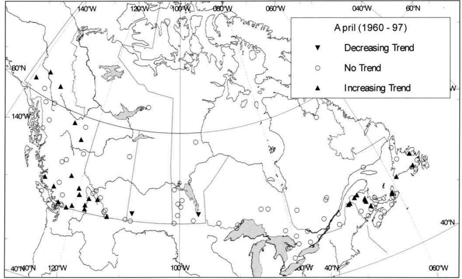
This study presents trends computed for the past 30-50 years for 11 hydroclimatic variables obtained from the recently created Canadian Reference Hydrometric Basin Network database. It was found that annual mean streamflow has generally decreased during the periods, with significant decreases detected in the southern part of the country. Monthly mean streamflow for most months also decreased, with the greatest decreases occurring in August and September. The exceptions are March and April, when significant increases in streamflow were observed. Significant increases were identified in lower percentiles of the daily streamflow frequency distribution over northern British Columbia and the Yukon Territory. In southern Canada, significant decreases were observed in all percentiles of the daily streamflow distribution. Breakup of river ice and the ensuing spring freshet occur significantly earlier, especially in British Columbia. There is also evidence to suggest earlier freeze-up of rivers, particularly in eastern Canada. The trends observed in hydroclimatic variables are entirely consistent with those identified in climatic variables in other Canadian studies. precipitation and temperature are likely to have impacted the hydrology of Canadian rivers, such as volume and timing of streamflow and river ice conditions. The hydrologic regime of a stream under specific geomorphic conditions represents the integrated basin response to various climatic inputs, with precipitation and temperature being very important ones. The evolution of basin geomorphology is very slow compared with possible climatic changes caused by anthropogenic increases of greenhouse gases. Therefore the changes in the hydrologic regimes of pristine or stable, unregulated basins generally reflect changes in climatic conditions and thus can be used as indicators for the purpose of climate change detection. It is thus important to analyze trends in various hydrologic variables of river basins which are not subjected to human regulation. In addition to providing an understanding of the impacts of climatic change on society and ecosystems, such analyses may provide independent corroborative evidence to confirm and/or to verify the results of trend detection for climate variables.
Journal of Hydrology, 1997
This paper evaluates the possible effects of climate change on four hydrologic variables pertaining to the magnitude and timing of hydrologic events within the Churchill-Nelson River Basin in westcentral Canada. By using the Mann-Kendall trend test, and a regionalization procedure, the severity of climatic effects within the river basin may be quantified and used to increase awareness of future consequences for water resource systems planning and management strategies. It was found that the magnitude of hydrologic events decreased over time while snowmelt runoff events occurred earlier.
Journal of Hydrology, 2009
It is generally accepted that the seasonal cycle of precipitation and temperature in cordillera of the western US exhibits a north-south pattern for annual, interannual and decadal time scales related to largescale climate patterns. In this paper we explore these relationships, with special attention to the role of local and regional physiographic, hydrogeologic and anthropogenic conditions on low-frequency climate and terrestrial response modes. The goal is to try to understand the spatio-temporal structure in historical precipitation, temperature and streamflow records (P-T-Q) in terms of climate, physiography, hydrogeology, and human impacts. Spatial coherence in time series is examined by classification of factor loadings from principal component analysis. Classification pattern of P-T-Q stations indicate that local physiography, the hydrogeology, and anthropogenic factors transform atmospheric forcing and terrestrial response into unique clusters. To study the temporal structure, dominant low-frequency oscillatory modes are identified for a region from historical P-T-Q records using singular spectrum analysis. Noise-free time trajectories are reconstructed from the extracted low-frequency modes (seasonal-decadal) for each contributing watershed area corresponding to streamflow observation stations, and the phase-plane plots are obtained. Together, the spatial classification and phase plane provides a means of detecting how large-scale hydroclimatic patterns relate to major landforms and anthropogenic impacts across the CRB. The main result of this paper is that resolving the relative impact of basin-wide patterns of climate, physiography and anthropogenic factors (irrigation, dams, etc.) on runoff response can be a useful tool for detection and attribution for each source of variability.
Hydrology and Earth System Sciences, 2021
East of the Continental Divide in the cold interior of Western Canada, the Mackenzie and Nelson River basins have some of the world's most extreme and variable climates, and the warming climate is changing the landscape, vegetation, cryosphere, and hydrology. Available data consist of streamflow records from a large number (395) of natural (unmanaged) gauged basins, where flow may be perennial or temporary, collected either year-round or during only the warm season, for a different series of years between 1910 and 2012. An annual warm-season time window where observations were available across all stations was used to classify (1) streamflow regime and (2) seasonal trend patterns. Streamflow trends were compared to changes in satellite Normalized Difference Indices. Clustering using dynamic time warping, which overcomes differences in streamflow timing due to latitude or elevation, identified 12 regime types. Streamflow regime types exhibit a strong connection to location; there is a strong distinction between mountains and plains and associated with ecozones. Clustering of seasonal trends resulted in six trend patterns that also follow a distinct spatial organization. The trend patterns include one with decreasing streamflow, four with different patterns of increasing streamflow, and one without structure. The spatial patterns of trends in mean, minimum, and maximum of Normalized Difference Indices of water and snow (NDWI and NDSI) were similar to each other but different from Normalized Difference Index of vegetation (NDVI) trends. Regime types, trend patterns, and satellite indices trends each showed spatially coherent patterns separating the Canadian Rockies and other mountain ranges in the west from the poorly defined drainage basins in the east and north. Three specific areas of change were identified: (i) in the mountains and cold taiga-covered subarctic, streamflow and greenness were increasing while wetness and snowcover were decreasing, (ii) in the forested Boreal Plains, particularly in the mountainous west, streamflows and greenness were decreasing but wetness and snowcover were not changing, and (iii) in the semi-arid to sub-humid agricultural Prairies, three patterns of increasing streamflow and an increase in the wetness index were observed. The largest changes in streamflow occurred in the eastern Canadian Prairies.
Journal of Hydrology, 2011
SummaryWithin the past few decades, Minnesota's land use change has responded rapidly to prevailing economic growth conditions, resulting in hydrologic characteristic alterations of the landscape and shifting the hydrologic balance of its watersheds. Regionalization using mean annual and mean monthly streamflow values was used to delineate hydrologic regimes with distinct temporal flow variations. By identifying hydrologic relationships between watersheds through an initial regionalization of mean annual streamflow time-series data, hydrologic regimes, each composed of watersheds with common hydrologic controlling variables, were identified. This paper summarizes how by applying factor analysis techniques to complete a statewide regionalization for Minnesota, hydrologic regimes were identified, each with a specific hydrologic signature; varying between three and four runoff periods of different durations. A geographic information system database was established to display the results of the regionalization and to identify hydrologic regime changes between the 1936-2008, 1936-1980, and 1950-2008 analysis intervals. Results delineated five hydrologic regimes for each of the three analysis periods. By focusing on each specific regime, further analyses were completed to identify significant increasing and decreasing trend characteristics. Review of the temporal variation for each regime using Kendall Tau trend analyses suggests that although variation in annual precipitation has an important influence on hydrologic variability, land cover and management proved to be a more direct controlling agent. Understanding the consequences of anthropogenic land use change on hydrologic processes within each defined regime should be the focus of future analyses.
Hydrology and Earth System Sciences Discussions, 2013
This study uses a 133 yr data set from the 1055 km 2 Skjern River catchment in a western Danish catchment to evaluate: long-term past climate changes in the area; the capability of a conceptual hydrological model NAM to simulate climate change impacts on river discharge; and the occurrences of droughts and floods in a changing climate. The degree of change in the climatic variables is examined using the non-parametric Mann-Kendall test. During the last 133 yr the area has experienced a significant change in precipitation of 46 % and a temperature change of 1.3 • C leading to (simulated) increases in discharge of 103 % and groundwater recharge of 172 %. Only a small part of the past climatic changes was found to be correlated to the climatic drivers: NAO, SCA and AMO. The NAM model was calibrated on the period 1961-1970 and showed generally an excellent match between simulated and observed discharge. The capability of the hydrological model to predict climate change impact was investigated by looking at performances outside the calibration period. The results showed a reduced model fit, especially for the modern time periods (after the 1970s), and not all hydrological changes could be explained. This might indicate that hydrological models cannot be expected to predict climate change impacts on discharge as accurately in the future, as they perform under present conditions, where they can be calibrated. The (simulated) stream discharge was subsequently analyzed using flood and drought indices based on the threshold method. The extreme signal was found to depend highly on the period chosen as reference to normal. The analysis, however, indicated enhanced amplitude of the hydrograph towards the drier extremes superimposed on the overall discharge increase leading to more relative drought periods.
2004
Changes in global climate will have significant impact on local and regional hydrological regimes, which will in turn affect ecological, social and economical systems. However, climate-change impact studies on hydrologic regime have been relatively rare until recently, mainly because Global Circulation Models, which are widely used to simulate future climate scenarios, do not provide hourly or daily rainfall reliable enough for hydrological modeling. Nevertheless, more reliable rainfall series corresponding to future climate scenarios can be derived from GCM outputs using the so called 'downscaling techniques'. This study applies two types of statistical (a stochastic and a regression based) downscaling techniques to generate the possible future values of local meteorological variables such as precipitation and temperature in the Chute-du-Diable sub-basin of the Saguenay watershed in northern Québec, Canada. The downscaled data is used as input to two different hydrologic models to simulate the corresponding future flow regime in the catchment. In addition to assessing the relative potential of the downscaling methods, the paper also provides comparative study results of the possible impact of climate change on river flow and total reservoir inflow in the Chute-du-Diable basin. Although the two downscaling techniques do not provide identical results, the time series generated by both methods indicates a general increasing trend in the mean daily temperature values. While the regression based downscaling technique resulted in an increasing trend in the mean and variability of daily precipitation values, such a trend is not obvious in the case of precipitation time series downscaled with the stochastic weather generator. Moreover, the hydrologic impact analysis made with the downscaled precipitation and temperature time series as input to the two hydrological models suggest an overall increasing trend in mean annual river flow and reservoir inflow as well as earlier spring peak flows in the basin.

Loading Preview
Sorry, preview is currently unavailable. You can download the paper by clicking the button above.
Journal of Hydrology, 1994
The paper examines the impact of climatic change on the timing of the spring runoff event. Impact detection is accomplished using a non-parametric statistical test for trend that is applied to the assembled data sets. The application of the approach is to a set of 84 natural rivers from the west-central region of Canada. The results indicate that there are a greater number of rivers that exhibit earlier spring runoff than can be attributed to chance occurrence. The observed impacts on the timing of spring runoff are more prevalent in the recent portion of the data record, which is consistent with what one would expect if the impacts are a result of greenhouse gas induced climatic change.
Journal of Hydrology, 2003
We are in agreement with Burn and Hag Elnur [J. Hydrol. 255 (2002) 107] that streamflow trends and variability are related to meteorological factors. We expanded the analysis of streamflow variability by relating annual peaks and spring (April, May, June) discharges to ENSO (El Niño-Southern Oscillation) events. Since geophysical considerations suggest that western Canada is warmer and drier than usual during El Niño but cooler and wetter under La Nina influences, flow variability of many western Canadian rivers is found to be correlated with winter values of such indices as the Southern Oscillation Index (SOI), Multivariate ENSO Index (MEI) or PNA (Pacific/North American Index). The spatial pattern of the non-parametric Spearman's r 2 (for streamflow vs SOI) indicates a general correspondence with the correlation pattern of SOI-precipitation reported by Shabbar et al. [J. Climate 10 (1997) 3016]. This reinforces the linkage between streamflow variability, precipitation and climatic forcing.
2009
This study examines the geographic structure of observed trends in key hydrologically relevant variables across the western United States at 1 /88 spatial resolution during the period 1950-99. Geographical regions, latitude bands, and elevation classes where these trends are statistically significantly different from trends associated with natural climate variations are identified. Variables analyzed include late-winter and spring temperature, winter-total snowy days as a fraction of winter-total wet days, 1 April snow water equivalent (SWE) as a fraction of October-March (ONDJFM) precipitation total [precip(ONDJFM)], and seasonal [JFM] accumulated runoff as a fraction of water-year accumulated runoff. Observed changes were compared to natural internal climate variability simulated by an 850-yr control run of the finite volume version of the Community Climate System Model, version 3 (CCSM3-FV), statistically downscaled to a 1 /88 grid using the method of constructed analogs. Both observed and downscaled model temperature and precipitation data were then used to drive the Variable Infiltration Capacity (VIC) hydrological model to obtain the hydrological variables analyzed in this study. Large trends (magnitudes found less than 5% of the time in the long control run) are common in the observations and occupy a substantial part (37%-42%) of the mountainous western United States. These trends are strongly related to the large-scale warming that appears over 89% of the domain. The strongest changes in the hydrologic variables, unlikely to be associated with natural variability alone, have occurred at medium elevations [750-2500 m for JFM runoff fractions and 500-3000 m for SWE/Precip(ONDJFM)] where warming has pushed temperatures from slightly below to slightly above freezing. Further analysis using the data on selected catchments indicates that hydroclimatic variables must have changed significantly (at 95% confidence level) over at least 45% of the total catchment area to achieve a detectable trend in measures accumulated to the catchment scale.
Journal of Hydrology, 2006
Trends and variability in the hydrological regime were analyzed for the Mackenzie River Basin in northern Canada. The procedure utilized the Mann-Kendall non-parametric test to detect trends, the Trend Free Pre-Whitening (TFPW) approach for correcting time-series data for autocorrelation and a bootstrap resampling method to account for the cross-correlation structure of the data. A total of 19 hydrological and six meteorological variables were selected for the study. Analysis was conducted on hydrological data from a network of 54 hydrometric stations and meteorological data from a network of 10 stations. The results indicated that several hydrological variables exhibit a greater number of significant trends than are expected to occur by chance. Noteworthy were strong increasing trends over the winter month flows of December to April as well as in the annual minimum flow and weak decreasing trends in the early summer and late fall flows as well as in the annual mean flow. An earlier onset of the spring freshet is noted over the basin. The results are expected to assist water resources managers and policy makers in making better planning decisions in the Mackenzie River Basin. q
Canadian Water Resources Journal, 2012
The research described in this paper examines changes in the hydrologic cycle in the Mackenzie River Basin (MRB) in northern Canada. The study focuses on temperature, precipitation, runoff, evapotranspiration and storage. A distributed hydrological model is used with two different climate input data sets: Environment Canada gridded observed data and the European Centre for Medium-range Weather Forecasting (ECMWF) reanalysis climate data (ERA-40). Both data sets were used to estimate runoff and evapotranspiration. The resulting hydrological variables were assessed for trends on a monthly and annual basis using the Mann-Kendall non-parametric trend test. The results reveal a general pattern of warming temperatures, and increasing precipitation and evapotranspiration. However, an overall decrease in runoff and in storage were detected for results derived from the Environment Canada data set while an overall increase in runoff and in storage were detected for results derived from the ECMWF data set. The sensitivity of mean annual runoff to changes in climate was also estimated using a non-parametric estimator. The results of the analysis can be used to better prepare for the potential impacts of climate change on water availability and water resource infrastructure in the MRB. Ré sumé : La recherche décrite dans la présente communication porte sur les changements dans le cycle hydrologique du bassin du fleuve Mackenzie dans le Nord du Canada. L'étude est axée sur la température, les précipitations, le ruissellement, l'évapotranspiration et l'emmagasinement. Un modèle hydrologique distribué est utilisé avec deux ensembles différents de données d'entrée climatiques : données observées sur grille d'Environnement Canada et données climatiques des réanalyses ERA-40 du Centre européen pour les prévisions météorologiques à moyen terme (CEPMMT). Les deux ensembles de données ont été utilisés afin d'estimer le ruissellement et l'évapotranspiration. Les variables hydrologiques qui en ont résulté ont été évaluées afin de dégager les tendances sur une
Canadian Water Resources Journal, 2000
Climatic and hydrologic variations between the decades 1976-1985 and 1986-95 are examined at 210 climate stations for temperature,2Tl climate stations for precipitation, and 642 hydrology stations from across Canada. The variations in climate are distributed across a broad spatial area. Temperatures were generally warmer in the more recent decade, with many stations showing significant increases during spring and fall. Significant decreases in temperature were found during winter in eastern Canada. Significant increases in temperature were more frequent in western Canada than in the east. Significant decreases in precipitation were also more prevalent in the north, as were increases in the south, except for Ontario and Quebec where little or no change has taken place. The hydrologic responses to these variations in climate are classified into four hydrograph types and six patterns of shifts in streamflow between the two decades. The 642 hydrologic stations fall into pr6cipitations dtaient dgalement plus courantes dans le Nord, tout comme l'6taient Ies hausses dans le Sud, sauf en Ontario et au Qudbec, oil l'on a enregistrd que tEnvironment Canada, Vancouver, BC
Journal of the Croatian Association of Civil Engineers, 2014
For Indicators of Hydrological Alterations, nonparametric analysis of trend magnitude using Theil-Sen method and Mann-Kendall trend significance test has been performed in the Danube river basin in Croatia. Analysis have shown disturbing decreasing of May and June monthly flows resulting in extended low water season with possible negative impact on ecosystems and water usage. It is obvious that increase of water management resilience and adaptability is needed to fulfil more efficiently requirements of water users.
Canadian Water Resources Journal, 1994
The continuing build-up of greenhouse gases in the atmosphere has led to legitimate concerns that significant changes in the earth's climate and in regional water budgets may be imminent. However, to date, a set of scientifically acceptable criteria have not been developed for establishing unambiguously that climatic change has taken place. Hydrological measurements could be important indicators of the onset and magnitude of such changes. However, further consideration of the role of hydrological and hydrometeorological measurements in a climatic change detection network reveals that their utility is dependent on many factors. These factors are the effects of climatic change on the water cycle, the requirements for long-term records at key locations, the need for adequate statistical techniques for determining the onset of change, and the difficulties in separating climatic change signals from other signals present in the hydrological records. After a brief review of the possible effects of climatic change on the hydrological cycle, this paper discusses criteria for the design of an integrated system for monitoring and detecting climatic change. Different hydrological and hydrometeorological parameters are reviewed to determine the degree to which each one could contribute information related to these criteria. The paper concludes
Journal of Hydrology, 2013
Hydrological frequency analysis (HFA) relies on a number of assumptions on the data series, especially independence, homogeneity and stationarity. In the univariate setting, these assumptions are generally checked before the modeling step. During the last decade, multivariate HFA approaches have gained popularity since most hydrological events can be described through a number of dependent characteristics, e.g. peak, volume and duration for floods. However, checking the above assumptions remains neglected in the multivariate HFA literature whereas the focus is directly on the modeling. For a reliable analysis and accurate results, these assumptions should also be checked prior to modeling in the multivariate setting. The present paper attempts to start bridging this gap in the multivariate HFA by highlighting the importance of the testing step and focusing on the review and application of nonparametric tests for monotonic trends. The presented multivariate trend tests are usually developed and employed to treat water quality data. In the present work, two types of multivariate applications are performed, multi-variable for flood attributes and multi-site for different locations. The results indicate that, in both types of applications, the univariate and multivariate tests led to the detection of different trend signals. It is hence recommended to jointly apply univariate and multivariate trend tests in order to capture all existing trend components and guide the user towards the appropriate models.
Water Resources Research, 2007
1] Multivariate linear regression is one of the most popular modeling tools in hydrology and climate sciences for explaining the link between key variables. Piecewise linear regression is not always appropriate since the relationship may experiment sudden changes due to climatic, environmental, or anthropogenic perturbations. To address this issue, a practical and general approach to the Bayesian analysis of the multivariate regression model is presented. The approach allows simultaneous single change point detection in a multivariate sample and can account for missing data in the response variables and/or in the explicative variables. It also improves on recently published change point detection methodologies by allowing a more flexible and thus more realistic prior specification for the existence of a change and the date of change as well as for the regression parameters. The estimation of all unknown parameters is achieved by Monte Carlo Markov chain simulations. It is shown that the developed approach is able to reproduce the results of Rasmussen (2001) as well as those of . Furthermore, two of the examples provided in the paper show that the proposed methodology can readily be applied to some problems that cannot be addressed by any of the above-mentioned approaches because of limiting model structure and/or restrictive prior assumptions. The first of these examples deals with single change point detection in the multivariate linear relationship between mean basin-scale precipitation at different periods of the year and the summer-autumn flood peaks of the Broadback River located in northern Quebec, Canada. The second one addresses the problem of missing data estimation with uncertainty assessment in multisite streamflow records with a possible simultaneous shift in mean streamflow values that occurred at an unknown date. Citation: Seidou, O., J. J. Asselin, and T. B. M. J. Ouarda (2007), Bayesian multivariate linear regression with application to change point models in hydrometeorological variables, Water Resour. Res., 43, W08401,
Water Resources Research, 2007
A large number of models in hydrology and climate sciences rely on multiple linear regression to explain the link between key variables. The relationship in the physical world may experiment sudden changes because of climatic, environmental, or anthropogenic perturbations. To deal with this issue, a Bayesian method of multiple changepoint detection in multiple linear regression is proposed in this paper. It is an adaptation of the recursion-based multiple changepoint method of to the classical multiple linear model. A new class of priors for the parameters of the multiple linear model is introduced, and useful formulas are derived that permit straightforward computation of the posterior distribution of the changepoints. The proposed method is numerically efficient and does not involve time consuming Monte-Carlo Markov Chain simulation as opposed to other Bayesian changepoint methods. It allows fast and straightforward simulation of the probability of each possible number of changepoints as well as the posterior probability distribution of each changepoint conditional on the number of changes. The approach is validated on simulated data sets and then compared to the methodology of on two practical problems, as follows: (1) the changepoint detection in the multiple linear relationship between mean basin scale precipitation at different periods of the year and the summer-autumn flood peaks of the Broadback River located in Northern Quebec, Canada; and (b) the detection of trend variations in the streamflows of the Ogoki River located in the province of Ontario, Canada.
2012
Spatial distribution of land use can have a substantial effect on surface and groundwater quality. Our objective was to test for trends in flow components and water quality related to changes in land use in the Alafia and Hillsborough River watersheds in Florida, USA, over the period 1974-2007. In addition, water quality statistics were evaluated in the perspective of numeric water quality criteria and proposed reclassification of segments of the Alafia River. Trends in 10 water quality parameters and three discharge variables were evaluated using a nonparametric trend detection test. Results of land use analysis indicated substantial urbanization and loss of agricultural land in the study area. Discharge variables did not exhibit significant trends, whereas trends in the majority of water quality concentrations were negative or nonsignificant with total nitrogen and total Kjeldahl nitrogen as exceptions showing positive trends. Changes in nutrient pathways could not be clearly identified. Considering recently promulgated numeric nutrient criteria and standards for dissolved fluoride, much of the Alafia River was found to be out of compliance. While there were land use changes and changes in water quality over the study period, it was difficult to identify a direct cause-effect relationship. Responses to regulatory efforts, such as the Clean Water Act and improvements in phosphate mining practices, may have had greater impacts on water quality than changes in land use.
Hydrological Processes, 2011
Much of the discussion on hydrological trends and variability in the source region of the Yellow River centres on the mean values of the mainstream flows. Changes in hydrological extremes in the mainstream as well as in the tributary flows are largely unexplored. Although decreasing water availability has been noted, the nature of those changes is less explored. This article investigates trends and variability in the hydrological regimes (both mean values and extreme events) and their links with the local climate in the source region of the Yellow River over the last 50 years . This large catchment is relatively undisturbed by anthropogenic influences such as abstraction and impoundments, enabling the characterization of widely natural, climate-driven trends. A total of 27 hydrological variables were used as indicators for the analysis. Streamflow records from six major headwater catchments and climatic data from seven stations were studied. The trend results vary considerably from one river basin to another, and become more accentuated with longer time period. Overall, the source region of the Yellow River is characterized by an overall tendency towards decreasing water availability. Noteworthy are strong decreasing trends in the winter (dry season) monthly flows of January to March and September as well as in annual mean flow, annual 1-, 3-, 7-, 30-and 90-day maxima and minima flows for Maqu and Tangnag catchments over the period 1959-2008. The hydrological variables studied are closely related to precipitation in the wet season (June, July, August and September), indicating that the widespread decrease in wet season precipitation is expected to be associated with significant decrease in streamflow. To conclude, decreasing precipitation, particularly in the wet season, along with increasing temperature can be associated with pronounced decrease in water resources, posing a significant challenge to downstream water uses.
Hydrological Processes, 2012
The abrupt changes in the streamflow and sediment load at nine hydrological stations of the Pearl River basin were systematically analysed by using the simple two-phase linear regression scheme and the coherency analysis technique. Possible underlying causes were also discussed. Our study results indicated that abrupt changes in the streamflow occurred mainly in the early 1990s. The change points were followed by significant decreasing streamflow. Multiscale abrupt behaviour of the sediment load classified the hydrological stations into two groups: (1) Xiaolongtan, Nanning and Liuzhou; and (2) Qianjiang, Dahuangjiangkou, Wuzhou, Gaoyao, Shijiao and Boluo. The grouped categories implied obvious influences of water reservoirs on the hydrological processes of the Pearl River. On the basis of analysis of the locations and the construction time of the water reservoirs, and also the time when the change points occurred, we figured out different ways the water reservoirs impacted the hydrological processes within the Pearl River basin. As for the hydrological variation along the mainstream of the Pearl River, the water reservoirs have considerable influences on both the streamflow and sediment load variations; however, more influences seemed to be exerted on the sediment load transport. In the North River, the hydrological processes seemed to be influenced mainly by climate changes. In the East River, the hydrological variations tended to be impacted by the water reservoirs. The study results also indicated no fixed modes when we address the influences of water reservoirs on hydrological processes. Drainage area and regulation behaviour of the water reservoirs should be taken into account. The results of this study will be of considerable importance for the effective water resources management of the Pearl River basin under the changing environment.
Stochastic Environmental Research and Risk Assessment, 2012
Many impact studies require climate change information at a finer resolution than that provided by general circulation models (GCMs). Therefore the outputs from GCMs have to be downscaled to obtain the finer resolution climate change scenarios. In this study, an automated statistical downscaling (ASD) regression-based approach is proposed for predicting the daily precipitation of 138 main meteorological stations in the Yangtze River basin for 2010-2099 by statistical downscaling of the outputs of general circulation model (HadCM3) under A2 and B2 scenarios. After that, the spatial-temporal changes of the amount and the extremes of predicted precipitation in the Yangtze River basin are investigated by Mann-Kendall trend test and spatial interpolation. The results showed that: (1) the amount and the change pattern of precipitation could be reasonably simulated by ASD; (2) the predicted annual precipitation will decrease in all sub-catchments during 2020s, while increase in all sub-catchments of the Yangtze River Basin during 2050s and during 2080s, respectively, under A2 scenario. However, they have mix-trend in each sub-catchment of Yangtze River basin during 2020s, but increase in all sub-catchments during 2050s and 2080s, except for Hanjiang River region during 2080s, as far as B2 scenario is concerned; and (3) the significant increasing trend of the precipitation intensity and maximum precipitation are mainly occurred in the northwest upper part and the middle part of the Yangtze River basin for the whole year and summer under both climate change scenarios and the middle of 2040-2060 can be regarded as the starting point for pattern change of precipitation maxima.
Theoretical and Applied Climatology, 2011
This paper presents the methods, procedure and results in studying spatial and temporal characteristics of rainfall in Malawi, a data scarce region, between 1960 and 2006. Rainfall variables and indicators from rainfall readings at 42 stations in Malawi, excluding Lake Malawi, were analysed at monthly, seasonal and annual scales. In the study, the data were firstly subjected to quality checks through the cumulative deviations test and the standard normal homogeneity test. Spatial rainfall variability was investigated using the spatial correlation function. Temporal trends were analysed using Mann-Kendall and linear regression methods. Heterogeneity of monthly rainfall was investigated using the precipitation concentration index (PCI). Finally, inter-annual and intra-annual rainfall variability were tested using normalized precipitation anomaly series of annual rainfall series (|AR|) and the PCI (|APCI|), respectively. The results showed that (1) most stations revealed statistically non-significant decreasing rainfall trends for annual, seasonal, monthly and the individual months from March to December at the 5% significance level. The months of January and February (the highest rainfall months), however, had overall positive but statistically non-significant trends countrywide, suggesting more concentration of the seasonal rainfall around these months.
Hydrological Sciences Journal-journal Des Sciences Hydrologiques, 2012
According to the Peruvian agricultural ministry, the Pacific watersheds where the great cities and intense farming are located only benefit from 1% of the available freshwater in Peru. Hence a thorough knowledge of the hydrology of this region is of particular importance. In the paper, analysis of this region and of the two other main Peruvian drainages, the Titicaca and
2012
The hydroclimatology of the Peruvian Amazon-Andes basin (PAB) which surface corresponding to 7% of the Amazon basin is still poorly documented. We propose here an extended and original analysis of the temporal evolution of monthly rainfall, mean temperature (T mean ), maximum temperature (T max ) and minimum temperature (T min ) time series over two PABs (Huallaga and Ucayali) over the last 40 years. This analysis is based on a new and more complete database that includes 77 weather stations over the 1965-2007 period, and we focus our attention on both annual and seasonal meteorological time series. A positive significant trend in mean temperature of 0.09 C per decade is detected over the region with similar values in the Andes and rainforest when considering average data. However, a high percentage of stations with significant T mean positive trends are located over the Andes region. Finally, changes in the mean values occurred earlier in T max (during the 1970s) than in T min (during the 1980s). In the PAB, there is neither trend nor mean change in rainfall during the 1965-2007 period. However, annual, summer and autumn rainfall in the southern Andes presents an important interannual variability that is associated with the sea surface temperature in the tropical Atlantic Ocean while there are limited relationships between rainfall and El Niño-Southern Oscillation (ENSO) events. On the contrary, the interannual temperature variability is mainly related to ENSO events.
Climatic Change, 2011
This paper examines trends in streamflow and their links with local climate in the Karkheh River and its major tributaries, which originate from the Zagros Mountains, Iran. Streamflow records from five mainstream stations for the period 1961-2001 were used to examine trends in a number of streamflow variables. The studied variables were mean annual and monthly flows, 1 and 7 days maximum and minimum flows, timing of the 1-day maxima and minima, and the number and duration of high and low flow pulses. Similarly, the precipitation and temperature data from seven climate stations for the period from 1950s to 2003 were used to examine trends in climatic variables and their correlation with the streamflow. The Spearman Rank test was used for the detection of trends and the correlation analysis was based on the Pearson method. The results reveal a number of significant trends in streamflow variables both increasing (e.g. December flows) and decreasing (e.g. May flows) for all stations. However, some trends were not spatially uniform. For example, decline in low flow characteristics were more significant in the upper parts of the basin, whereas increasing trends in floods and winter flows were noteworthy in the middle parts of the basin. Most of these trends could be attributed to precipitation changes. The results show that the decline in April and May precipitation causes the decline in the low flows while the increase in winter (particularly March) precipitation coupled with temperature changes lead to increase in the flood regime. The observed trends at the Jelogir station on the Karkheh River reflect the combined effect of the upstream catchments. The significant trends observed in a number of I. Masih (B) · V. Smakhtin
Hydrological Processes, 2013
Mean daily streamflow records from 44 river basins in Romania with an undisturbed runoff regime have been analyzed for trends with the nonparametric Mann-Kendall test for two periods of study : 1961-2009 (25 stations) and 1975-2009 (44 stations). The statistical significance of trends was tested for each station on an annual and seasonal basis, for different streamflow quantiles. In order to account for the presence of serial correlation that might lead to an erroneous rejection of the null hypothesis, a trend-free prewhitening was applied to the original data series. The regional field significance of trends is tested by a bootstrap procedure. Changes in the streamflow regime in Romania are demonstrated. The main identified trends are an increase in winter and autumn streamflow since 1961 and a decrease in summer flow since 1975. The streamflow trends are well explained by recent changes in temperature and precipitation that occurred in the last 50 years.
Water Resources Research, 2010
1] Daily streamflow from stations close to five Swiss glaciers is analyzed for trends with the Mann-Kendall test. We consider a common period of record and longer periods based on data availability. The trend statistical significance is tested on annual and seasonal bases. We also examine changes in precipitation, temperature, and snow cover characteristics. Highly glacierized basins show statistically significant positive trends in annual streamflow caused by increasing streamflow in spring and summer. Trends are more numerous and stronger at lower and mid than at the upper quantiles. The basin characterized by lower glacier coverage, conversely, does not exhibit consistently statistically significant trends. Changes in precipitation are not sufficient to explain the observed streamflow trends. Air temperature sees an increase in mean, minimum, and maximum values at all sites. Variations in the seasonal snow accumulation and ablation process are evident. Solid precipitation is decreasing at all sites and trends may be due to a shift from snowfall into rainfall. Mean snow depth is also decreasing, and its duration is getting shorter because of a decrease in solid precipitation and enhanced melting. Trend magnitude attenuates with longer time series. Contrasting trends are detected for different subperiods in the last 70 years: statistically significant negative trends are observed in the periods 1944-1974 and 1954-1984 for Aletschgletscher, in contrast with the results for the common period. These trends are explained by different rates of ice volume changes, and the sign of trends is clearly related to phases of positive or negative glacier mass balance.
Hydrological Processes, 2011
Snowfall is an important part of the yearly water balance for the Catskill Mountains in New York State, the location of water supply reservoirs for New York City. Recent studies have shown that the effects of climate change on the hydrology of the Catskills will most likely create (1) a decrease in the proportion of precipitation falling as snow, (2) a shift in the timing of snowmelt that will cause snowmelt-supplemented streamflow events to occur earlier in the fall and winter, and (3) a decrease in the magnitude of traditionally high April streamflow. The shift in timing of snowmelt-influenced streamflow events is measured by the winter-early spring centre of volume (WSCV), defined as the Julian Day on which half the total streamflow volume from January to May occurs. Studies of streamflow, precipitation, and temperature trends in the last 50 years have shown that the WSCV is already earlier by about 5-10 days. This study investigates the use of watershed-scale snowpack and snowmelt algorithms that are incorporated in two existing watershed water quality models, Generalized Watershed Loading Functions-Variable Source Area (GWLF-VSA) and Soil and Water Assessment Tool (SWAT), to capture the potential effects of climate change on the timing and magnitude of streamflow during the late fall, winter, and early spring for the Catskill Mountain region. The GWLF-VSA model reasonably simulated the recent shifts in the winter streamflow timing, with simulations over the previous 50-year period yielding shifts in WSCV of 2-15 days. The SWAT model yielded similar results as the GWLF-VSA simulations. Scenarios of potential climate change 100 years in the future showed a similar shift in direction of timing winter streamflow, but at a larger magnitude than observed to date with WSCV occurring 15-20 days earlier.
Hydrological Processes, 2013
The Manso Glacier (~41 S, 72 W), in the northern Patagonian Andes of Argentina, is a regenerated glacier that, like many other glaciers in the region and elsewhere, has been showing a significant retreat. Glacial melt water feeds the Manso Superior River, which, before crossing the Andes to reach a Pacific outfall, flows through the Mascardi (a deep, oligotrophic and monomictic lake) and significantly smaller Hess and Steffen lakes. Harmonic analysis of Mascardi's lake level series suggests that the El Niño-Southern Oscillation signal has been strong during the 1985-1995 decade but has grown weaker during the initial decade of the 21st century. Hydrological trend analyses applied in data recorded in the uppermost reaches show a monthly and annual decreasing trend in the Manso Superior River discharge series and Mascardi's lake level, which are connected with both, decreasing melt water discharge and (austral) wintertime atmospheric precipitation. Downstream, the decreasing signal initially looses statistical significance and then, when flowing through Steffen Lake, reverses the lake level trend that becomes significantly positive. This suggests that, on its way to the Pacific Ocean, the Manso River receives abundant Andean snow melt water and atmospheric precipitation, which are sufficient to obliterate the negative trend recorded in the uppermost reaches. The reason for this local phenomenon is that the Manso is an antecedent river (aka superposed stream), and hence, the valley crossing the Andes allows the incursion of Pacific humidity that modifies the hydrological regime several hundred kilometres inland. 150 200 250 300 J J F F M M A A M M J J J J A
Arid Land Research and Management, 2014
soil erosion and sediment yield, more attention should be paid to changes in land use pattern and the impacts of soil and water conservation.
Canadian Journal of Earth Sciences, 2009
Groundwater plays a major role in social and economic development and in human and ecosystem health. However, little is known about the potential impacts of climate change on this resource in Canada, namely if groundwater recharge is increasing or decreasing over time. This paper focuses on trend statistical analysis of historical series of baseflow and groundwater levels and their field significance as indicators of recharge. Monitoring wells are mainly located in the southern half of western Canada, where few gauging stations either are available or provide significant trends. Both data sets are thus complementary. Results show that most available groundwater level series have significant trends (80%), whereas most available baseflow series have not (3%-33%). However, groundwater level series usually show smaller slope magnitudes than baseflow series. Mixed trends are often observed across Canada for a given variable, period, or series length, although some regions can have marked trends. For instance, values below the 558N latitude, and especially values in Atlantic Canada, show mostly downward trends (decreasing recharge). Values north of the 558 parallel often show upward trends. All groundwater level results are field significant at the 10% level, versus only 35% for baseflow results, but they show mixed results. Baseflow values show a majority of downward trends for annual values and the summer period for 40-and 50-year series, thus showing field significance, whereas mixed results are observed for 30-year series and the spring, fall, and winter seasons.
Hydrological Processes, 2009
The objective of this paper is to verify the applicability of the trend-free pre-whitening (TFPW) approach, developed by for positively correlated series, to negatively correlated series using similar Monte Carlo simulations. This study was initiated when a project on trend detection for streamflow and baseflow series across Canada revealed that a significant number of series had negative correlation coefficients. The TFPW procedure confirmed to be also well suited for negatively correlated series. This study also showed that the estimated values for slopes (trends) and correlation coefficients of the prewhitened series are affected by the sample size, especially for negatively correlated series.
Österreichische Wasser- und Abfallwirtschaft, 2011
Regional Environmental Change, 2014
Forty-five years of hydrological data from 12 watersheds in the Abbay Basin, Ethiopia, were tested for possible trends over the entire time series and differences in medians (step-wise changes) between three sub-periods. The classification of the sub-periods was based on the major political changes in 1975 and 1991. Variables investigated were rainfall (P), total flow (Q t ), high flow (Q h ), low flow (Q l ), low flow index (LFI) and run-off coefficient (C). Data were checked for outliers, errors and homogeneity. Trend was tested after serial and cross-correlation tests. The data for each variable were serially uncorrelated from 1 to 10 lag years. There were five globally significant trends out of 50 test cases and 36 significant step-wise changes out of 180 tests. The majority of the significant changes were watershed specific. Run-off coefficient was the single variable showing a consistently increasing trend and stood for ca. 25 % of the total significant trends and step-wise changes. Half of these changes occurred after 1991. We concluded that despite the land use policy changes in 1975 and 1991, as well as the long-term soil degradation, the hydrological regime was quite stable over the 45-year period, with the exception of an increase in the run-off coefficient in the latter part of the run-off record in some watersheds.
Theoretical and Applied Climatology
Sixty-year-long January-March (JFM) rainfall data from four (4) stations along the Kalahari Transect were analyzed for long-term trends and abrupt changes in rainfall regimes. On average, JFM rainfall accounts for more than 50 % of annual rainfall in the region. Mann-Kendall trend test has shown an insignificant heterogeneous trend in the seasonal rainfall of −1.097, 0.029, −0.407, and −1.327 mm/year for Maun, Ghanzi, Tsabong, and Tshane, respectively. An abrupt change in rainfall regimes in these areas was investigated and was found to occur in the year 1982 for all stations. The change is related to large-scale atmospheric circulations. Analysis of largescale atmospheric circulations before 1982 over the region has shown the formation of a tropical low pressure convective system over the Kalahari Transect. The tropical system shifted eastward after 1982 to be centered over southeastern southern Africa with a significant reduction in rainfall over the Kalahari. A direct impact of this is the livestock-induced overgrazing which has lead to excessive removal of palatable herbaceous species thereby giving woody species, such as Accacia mellifera and Grewia flava, a competitive edge for dominance in the ecosystems. Seed production of A. mellifera depends on rainfall; therefore, abrupt changes in rainfall regimes impact livelihood and eco-tourism industry. The correlation studies between rainfall anomalies and NINO3.4 indices show a reduction in the influence of El-Niño Southern Oscillation on the Kalahari Transect rainfall after 1982.
Hydrological Sciences Journal, 2015
2015): Regional sea surface temperatures explain spatial and temporal variation of summer precipitation in the source region of the Yellow River, Hydrological Sciences Journal, Abstract The summer precipitation (June-September) in the source region of the Yellow River accounts for about 70% of the annual total, playing an important role in water availability. This study divided the source region of the Yellow River into homogeneous zones based on precipitation variability using cluster analysis. Summer precipitation trends and teleconnections with global sea surface temperatures (SST) and Southern Oscillation Index (SOI) from 1961 to 2010 were investigated by Mann-Kendall test and Pearson product-moment correlation analysis. The results show that the northwest part (zone 1) had a non-significantly increasing trend, and the middle and southeast parts (zones 2 and 3) that receive the most precipitation displayed a statistically significant decreasing trend for summer precipitation. The summer precipitation in the whole region shows statistically significant negative correlations with the central Pacific SST for 0-4 month lags and with the southern Indian and Atlantic Ocean SST for 5-8 month lags. Analyses of sub-regions reveal intricate and complex correlations with different SST areas that further explain the summer precipitation variability. The SOI had significant positive correlations mainly for 0-2 month lag with summer precipitation in the source region of the Yellow River. It is seen that El Niño Southern Oscillation (ENSO) events have an influence on the summer precipitation, and the predominant negative correlations indicate that higher SST in equatorial Pacific areas corresponding to El Niño coincides with less summer precipitation in the source region of the Yellow River. Downloaded by [Lund University Libraries] at 02:14 16 June 2015
International Journal of Climatology, 2011
Annual, seasonal and monthly rainfall trends from 1961 to 2006 period were analysed in this study by applying various statistical tools to data from 553 Spanish weather stations. The magnitude of the trends was derived from the slopes of the regression lines using the least squares method, while the statistical significance was determined using the non-parametric Mann-Kendall test. Geostatistical interpolation techniques were applied to generate rainfall trend surfaces. Combining classic trends tests and spatially interpolated precipitation permits the spatio-temporal visualization of detected trends. Updated trends reveal that rainfall is generally decreasing in January, February, March, April, and June. Around 61, 44 and 12% of the whole territory is evidencing significant negative trends in February, June and March, respectively. Significant precipitation decreases are also noted in more than 28% of Spain in summer and winter. On the contrary, rainfall is significantly increasing in October in more than 21% of Spain and areas mainly located in north-western areas. May, August, September and autumn also show significant positive trends in the period 1961-2006, although the percentages are lower than for negative trends. Finally, the annual precipitation is significantly decreasing in 11% of the territory.
International Journal of Climatology, 2011
Changes in the statistical distribution of rainfall amounts have been studied in four Mediterranean regions: the French and Spanish Mediterranean coasts, Sardinia Island, and the Calabrian region, in Italy. The largest precipitation series (from 70 to 150 years) in these zones have been collected and studied at yearly and monthly time scales by means of different parametric and nonparametric techniques. Nonparametric procedures have focussed on continuous time series changes, while possible changes at the end of the 20th century have been studied developing a parametric method. Among the results obtaineddecades have been revealed as some of the driest ones since data are available in central and western Mediterranean. Despite that, such a finding is not always accompanied with a trend in the entire rainfall series. On the one hand, the low precipitation amounts detected in Central Mediterranean are caused in its major contribution by a diminution of the winter rainfall. On the other hand, a diminution of the spring and winter rainfall is the cause of the driest records since data are available in Western Mediterranean. Possible relations between the dry records and seasonal SLP-based indexes have been studied. The seasonal configurations of the North Atlantic Oscillation (NAO) have been calculated and their time series have provided a good perspective on the evolution of the most contributive synoptic patterns to climate variability at the region. The high frequency of positive seasonal phases of winter, spring and autumn NAO at the end of the 20th century and beginning of the 21st have been found as possible dynamic mechanism causing the last decades dryness. Moreover, moving correlations suggest a strengthening in the correlation between those seasonal NAOs and precipitation anomalies in Central and Western Mediterranean.
Water Resources Management, 2011
Winter and summer 7-day low flows of eighteen natural rivers in the St. Lawrence River watershed of Quebec were analyzed over the period from 1934 to 2000. The rivers were first subdivided into three modes using principal component analysis. Two of these modes are located on the south shore of the St. Lawrence River, respectively south (Southeast mode) and north (East mode) of the 47°N, and the third (Southwest mode) is located on the north shore. The Southeast mode shows a significant increase in 7-day low flows in winter and summer due to increasing summer and fall precipitation, whereas the Southwest mode shows a significant decrease in summer 7-day low flows due to an increase in evapotranspiration. No significant change in winter and summer 7-day low flows is observed in the East mode. Results show that the variability of 7-day low flows and their link with climate indices are mainly seasonally dependent. The North Atlantic Oscillation (NAO) is the only index which is correlated to 7-day low flows in all three modes. This correlation is positive for north shore rivers and negative for south shore rivers. Furthermore, only north shore rivers are correlated to NAO in both winter and summer.
Water Resources Research, 2015
Natural proxy records of hydroclimatic behavior, such as tree ring chronologies, are a rich source of information of past climate-driven nonstationarities in hydrologic variables. In this study, we investigate tree ring chronologies that demonstrate significant correlations with streamflows, with the objective of identifying the spatiotemporal patterns and extents of nonstationarities in climate and hydrology, which are essentially representations of past ''climate changes.'' First and second-order nonstationarities are of particular interest in this study. As a prerequisite, we develop a methodology to assess the consistency and credibility of a regional network of tree ring chronologies as proxies for hydrologic regime. This methodology involves a cluster analysis of available tree ring data to understand and evaluate their dependence structure, and a regional temporal-consistency plot to assess the consistency of different chronologies over time. The major headwater tributaries of the Saskatchewan River basin (SaskRB), the main source of surface water in the Canadian Prairie Provinces, are used as the case study. Results indicate that stationarity might never have existed in the hydrology of the region, as the statistical properties of annual paleo-hydrologic proxy records across the basin, i.e., the mean and autocorrelation structure, have consistently undergone significant changes (nonstationarities) at different points in the history of the region. The spatial pattern of the changes in the mean statistic has been variable with time, indicating a time-varying cross-correlation structure across the tributaries of the SaskRB. Conversely, the changes in the autocorrelation structure across the basin have been in harmony over time. The results demonstrate that the 89 year period of observational record in this region is a poor representation of the long-term properties of the hydrologic regime, and shorter periods, e.g., 30 year periods, are by no means representative. This paper highlights the need to broaden the understanding of hydrologic characteristics in any basin beyond the limited observational records, as an improved understanding is essential for more reliable assessment and management of available water resources.
Hydrological Processes, 2011
Huai River Basin, as the sixth largest river basin in China, has a high-regulated river system and has been facing severe water problems. In this article, the changing patterns of runoff and precipitation at 10 hydrological stations from 1956 to 2000 on the highly regulated river (Shaying River) and less-regulated river (Huai River) in the basin are evaluated at the monthly, seasonal and annual scales using the Mann-Kendall test and simple linear regression model. The results showed that: (1) No statistically significant trends of precipitation in the upper and middle Huai River Basins were detected at the annual scale, but the trend of annual runoff at Baiguishan, Zhoukou and Fuyang stations in Shaying River decreased significantly, whereas the others were not. Moreover, the decreasing trends of runoff for most months were significant in Shaying River, although the trend of monthly precipitation decreased significantly only in April in the whole research area and the number of months in the dry season having significantly decreasing trends in runoff was more than that in the wet season.
Canadian Water Resources Journal, 2004
A study of trends and variability of hydrological variables was conducted for natural streamflow gauging stations within two watersheds that are important sources of flow within the Mackenzie River Basin. A comparison was made between trend results for the Liard River Basin and for the Athabasca River Basin. These basins represent a north-south transect of high elevation headwater basins within the Mackenzie River system and are significant since they produce 34% of the annual flow, while occupying only 24% of the total drainage area. Trend analysis was conducted using the Mann-Kendall test with an approach that corrects for serial correlation. The global (or field) significance of the results for each watershed was evaluated using a bootstrap resampling approach. The relationships between trends in hydrological variables and trends in meteorological variables were investigated using partial correlation analysis. The results reveal more trends in some hydrological variables than are expected to occur by chance. In general, both basins exhibit an increase in winter flows and some increase in spring runoff. These increased flows are somewhat offset by decreases (not field significant) in summertime flow. Almost 50% of the stations used in the analysis show an increasing trend in annual minimum flows. Other differences in trend responses are noted for the two watersheds and possible explanations for the differences are hypothesized.
Hydrological Processes, 2013
Annual maximum rainfall data from 51 stations in Canada were analyzed for trends and changes by using the Mann-Kendall trend test and a bootstrap resampling approach, respectively. Rainfall data were analyzed for nine durations ranging from 5 min to 24 h. The data analyzed are typically used in the development of intensity-duration-frequency (IDF) curves, which are used for estimating design rainfall values that form an input for the design of critical water infrastructure. The results reveal more increasing than decreasing trends and changes in the data with more increasing changes and larger changes, noted for the longer rainfall durations. The results also indicate that a traditional trend test may not be sufficient when the interest is in identifying changes in design rainfall quantiles. + values indicate increasing trends, and Àvalues indicate decreasing trends. Figure 2. Spatial pattern of the trend results for the 1-h duration. N.S. denotes a trend that is not significant + values indicate larger quantiles for last 20 years, and Àvalues indicate smaller quantiles for the last 20 years. Bold entries indicate field significance at the 10% global significance level.
Hydrological Sciences Journal, 2008
Trend analysis was performed on streamflow data for a collection of stations on the Canadian Prairies, in terms of spring and summer runoff volumes, peak flow rates and peak flow occurrences, as well as an annual volume measure, for analysis periods of 1966-2005, 1971-2005, and 1976-2005. The Mann-Kendall statistical test for trend and bootstrap resampling were used to identify the trends and to determine the field significance of the trends. Partial correlation analysis was used to identify relationships between hydrological variables that exhibit a significant trend and meteorological variables that exhibit a significant trend. Noteworthy results include decreasing trends in the spring snowmelt runoff event volume and peak flow, decreasing trends (earlier occurrence) in the spring snowmelt runoff event peak date and decreasing trends in the seasonal (1 March-31 October) runoff volume. These trends can be attributed to a combination of reductions in snowfall and increases in temperatures during the winter months.
Hydrological Sciences Journal, 2014
Daily precipitation data from 31 Senegalese stations spanning the period from 1950 to 2007 were used to examine the inter-annual variations of seven rainfall indices: the annual mean precipitation (MEAN); the annual standard deviation of daily precipitation (STD); the frequency of wet days (PRCP1); the maximum number of consecutive dry days (CDD); the greatest 3-day total of rainfall (R3D); the wet day precipitation intensity (SDII); and the 90 th percentile of rain day precipitation (Prec90p). The indices were spatially averaged over three agroclimatic regions in Senegal. Trends in the averaged indices time series were assessed using both visual examination and a modified version of the Mann-Kendall test (MM-K). Initially negative significant trends in all seven indices suggest gradually drier conditions over the three agroclimatic regions between 1950 and 1980. In contrast, no significant trends or even positive significant trends were observed from the mid-1980s to 2007. The MM-K test was applied to all available data (1950-2007) and the period spanning from 1971 to 2000.
Environmental Monitoring and Assessment, 2012
The transformation of forest into pastures in the Brazilian Amazon leads to significant consequences to climate at local scale. In the region of Alta Floresta (Mato Grosso, Brazil), deforestation has been intense with over half the forests being cut since 1970. This article first examines the evolution of precipitation observed in this region and shows a significant trend in the decrease in total precipitation especially at the V. Dubreuil (B) · B. Funatsu · V. Nédélec end of the dry season and at the beginning of the rainy season. The study then compares the temperatures measured in cleared and forested sectors within a reserve in the area of Alta Floresta (Mato Grosso, Brazil) between 2006 and 2007. The cleared sector was always hotter and drier (from 5% to 10%) than the forested area. This difference was not only especially marked during the day when it reached on average 2 • C but also seemed to increase during the night with the onset of the dry season (+0.5 • C). The Urban Heat Island effect is also evident especially during the night and in the dry season.
Stochastic Environmental Research and Risk Assessment, 2014
We use the Dichotomous Markov Noise model with constant transition rates to describe the dynamics of fluctuations in the water level as a stochastic process, which is imposed on river discharge changes. By applying this model, two different regimes are determined for the long-term behaviour of the river. Based on these regimes, we define two nonparametric classes of the overall increasing/decreasing nature of the water level in the longterm behaviour, which are separated by an exponential steady state regime. In this paper, we develop a nonparametric testing procedure to test exponentially (steady state regime) against an alternative overall decreasing level distribution. The proposed test predicts the long-term regime behaviour of the river. The mathematical tools introduced to handle the problem should be of general use and the testing procedure can be considered as a new mathematical tool in the study of water level dynamics. Under conditions of data austerity and as a case of study, we examine the stochastic characteristics of the Zayandeh Rud (Zāyandé-Rūd or Zāyanderūd, also spelled as Zayandeh-Rood or Zayanderood) River (Isfahan, Iran) water level.
Water Resources Management, 2012
Global climate change could have important effects on various environmental variables in many countries around the world. Changes in precipitation regime directly affect water resources management. So that, it is important to analyze the changes in the spatial and temporal rainfall pattern in order to improve water resources management policies. For this reason, non-parametric Mann-Kendall rank correlation test is used in order to examine the existence of trends in annual and monthly rainfall distribution. To understand the regional differences of precipitation in Turkey, the detected trends are spatially interpolated using geostatistical techniques in a GIS environment. The main objective of this paper is to evaluate three interpolation methods, concerning their suitability for spatial prediction of temporal trends of Turkey's monthly and annual rainfall data. The study used a dense and homogeneous monthly precipitation database comprising 120 rain-gauge stations over a 32 years testing period of 1975-2009. The results conclusively show that significant positive trends are both infrequent and found only in outlying stations during March, April and October. In order to estimate and characterize the magnitude of observed changes at unmeasured locations, Ordinary Kriging, Inverse Distance Weighted and Completely Regularized Spline interpolation methods were employed and compared. A comparative analysis of interpolation techniques shows that Ordinary Kriging with having RMSE of 0.148 is the best choice. This is followed by Inverse Distance Weighted (RMSE 0.151), and Splines (RMSE 0.152). Cross validation of the results shows the largest over prediction at Kars rainfall station and largest under prediction at Burdur station. Upon for the examination of the cross-validation and spatial error clustering results, the Ordinary Kriging method was concluded to be the best algorithm in the interpolation process.
International Journal of Climatology, 2015
Drought is a major natural hazard that can have devastating impacts on regional agriculture, water resources and the environment. To assess the variability and pattern of drought characteristics in the Huang-Huai-Hai (HHH) Plain, the daily Standardized Precipitation Evapotranspiration Index (SPEI) is developed based on daily meteorological data in this study. The daily SPEI data are used, including Annual Total Drought Severity (ATDS), Annual Total Drought Duration (ATDD) and Annual Drought Frequency (ADF), which were calculated from 1981 to 2010 at 28 meteorological stations. We used the indices (ATDS, ATDD and ADF), Hovmöller diagrams and the reliable no parameter statistical methods of the Mann-Kendall test to assess the variability and pattern of drought characteristics for the period from 1981 to 2010 in the HHH plain. The results suggested that severe drought occurred in the 1980s, the late 1990s and the early 2000s, severe drought events occurred in 1981, 1986, 1997 and 2002. Decreasing trends for both ATDS and ATDD were found, and the drought situation did not worsen under global warming during the past 30 years, and the drought situation is alleviating in the entire HHH plain. The northeast and southwest regions of the HHH plain have suffered from more severe drought, and the north region is prone to drought. The results of the study can provide a scientific understanding for the adoption of countermeasures of regional defence against drought and also may serve as a reference point for drought hazard vulnerability analysis.
Theoretical and Applied Climatology, 2013
Your article is protected by copyright and all rights are held exclusively by Springer-Verlag Wien. This e-offprint is for personal use only and shall not be self-archived in electronic repositories. If you wish to self-archive your article, please use the accepted manuscript version for posting on your own website. You may further deposit the accepted manuscript version in any repository, provided it is only made publicly available 12 months after official publication or later and provided acknowledgement is given to the original source of publication and a link is inserted to the published article on Springer's website. The link must be accompanied by the following text: "The final publication is available at link.springer.com".
Geophysical Research Letters, 2010
Water Resources Research, 2008
This study investigates temporal evolution of 1-, 7-, 15-and 30-day annual and seasonal low· flow regimes of pristine river basins, included in the Canadian reference hydrometric basin network (RHBN), for three time frames : 1974-2003, 1964-2003 and 1954-2003. For the analysis, the RHBN stations are classified into three categories, which correspond to stations where annual low flows occur in winter only, summer only and both summer and winter seasons, respectively. Unlike in previous studies for the RHBN, such classification is essential to better understand and interpret the identified trends in low flow regimes in the RHBN. Nonparametric trend detection and bootstrap resampling approaches are used for the assessment of at-site temporal trends under the assumption of short-term persistence (STP). The results of the study demonstrate that previously suggested prewhitening and trend free pre-whitening approaches are inadequate in capturing the STP structure of low flow regimes compared to a bootstrap based approach. The analyses of 10 relatively longer records reveal that trends in low flow regimes exhibit fluctuating behavior and hence their temporal and spatial interpretations appear to be sensitive to the time frame chosen for the analysis. Furthermore, under the assumption of long-term persistence (LTP), which is a possible explanation for the fluctuating behavior of trends, many of the significant trends in low flow regimes, noted under the assumption of STP, become non-significant and their field significance also disappears. Therefore, correct identification of STP or LTP in time series of low flow regimes is very important as it has serious implications for the detection and interpretation of trends. hydrological trends in the presence of seriaI and cross correlations: review of the methodology and application to Canadian rivers, J. Hydrol. (in review) Khaliq, M.N., T.B.M.J. Ouarda, J.-C. Ondo, P. Gachon, and B. Bobée (2006), Frequency analysis of a sequence of dependent and/or non-stationary hydro-meteorological observations: A review, J Hydral., 329,534-552. Koutsoyiannis, D., and A. Montanari (2007), Statistical analysis ofhydroclimatic time series: Uncertainty and insights, Water Resour.
Scientific Reports
Ice-jam floods (IJFs) are important hydrological and hydraulic events in the northern hemisphere that are of major concern for citizens, authorities, insurance companies and government agencies. In recent years, there have been advances in assessing and quantifying climate change impacts on river ice processes, however, an understanding of climate change and regulation impacts on the timing and magnitude of IJFs remains limited. This study presents a global overview of IJF case studies and discusses IJF risks in North America, one of the most IJF prone regions according to literature. Then an assessment of shifts in the timing and magnitude of IJFs in Canada is presented analyzing flow data from 1107 hydrometric stations across Canada for the period from 1903 to 2015. The analyses show clear signals of climate change and regulation impacts in the timing and magnitude of IJFs, particularly in small basins. Ice-jam floods (IJFs) pose serious threats to riverine communities in the northern hemisphere where almost 60% of the rivers experience significant seasonal effects of river ice 1 . Compared to open water flood events that occur during the ice free season, IJFs can be more severe since, under the same or lower discharge, they can result in two to three times higher water depths than open water floods 2 . The feature that makes them particularly dangerous is their unpredictability of occurrence. IJFs are often sudden and difficult to anticipate which allows little time for the implementation of contingency measures, especially evacuation 3,4 . In the province of New Brunswick in Canada where detailed damage records are available, IJFs account for only one third of flood events, but they result in two thirds of total flood damages . Figure shows that IJFs are commonly reported in many northern countries across the world. They are largely reported in Canada 6,7 , United States 8,9 , Russia 10,11 , Poland 12,13 and China . It should be noted that the figure is not reflective of IJF susceptible regions in general as it only shows IJF case studies that are reported in journal articles. Many IJF prone areas might not have been reported in journal articles or reported only in conference proceeding papers and/or research reports. Examples are IJFs in Norway and Sweden that are cited in other literature 2,5 but are missing in Fig. . This reveals the gap in reporting in journal articles but not the absence of IJFs in other areas. The financial costs of IJF events are difficult to estimate and a full economic estimation of damage costs is yet to be conducted . The economic cost of IJFs in North America is estimated to be USD 300 million in 2017 17 . However, these existing approximations could be seriously underestimated considering single IJF events have been known to result in hundreds of millions of dollars in financial damages 1 such as the 2001 IJF in eastern Russia 18 , the 1996 IJF in Susquehanna River Basin in United States 19 and the recent IJF event at the interior Alaskan village of Galena in 2013 20 . Moreover, the current estimates account only for tangible monetary costs and do not reflect other serious implications such as residents' relocation and even loss of life 21 . Table shows the list of the top ten most costly IJFs reported in the literature. Most of these large-scale events in terms of economic losses have occurred in North America. The review of the IJF case studies indicates that North America is one of the most IJF prone regions in the world. Figure shows IJF events that have been reported in the United States and Canada. The sparse IJFs in Canada do not reflect low frequency of IJFs but rather limited availability of IJF records. Nevertheless, the figure does reveal eastern regions to be more prone to IJFs compared to far western regions. Most of the events are also reported between 40-70°N. In the US, the analyses of ice jam data from the Cold Regions Research and Engineering Laboratory (CRREL) shows that more frequent IJFs are observed in Alaska, New York, Montana, Vermont, Maine, Ohio and Nebraska, each state reporting more than 100 IJF events. Montana and New York are
Advances in Meteorology
Identifying rainfall trends in highly urbanized area is extremely important for various planning and implementation activities, including designing, maintaining and controlling of water distribution networks and sewer networks and mitigating flood damages. However, different available methods in trend analysis may produce comparable and contrasting results. Therefore, this paper presents an attempt in comparing some of the trend analysis methods using one of the highly urbanized areas in Sri Lanka, Colombo. Recorded rainfall data for 10 gauging stations for 30 years were tested using the MannKendall test, Sen’s slope estimator, Spearman’s rho test, and innovative graphical method. Results showcased comparable findings among three trend identification methods. Even though the graphical method is easier, it is advised to use it with a proper statistical method due to its identification difficulties when the data scatter has some outliers. Nevertheless, it was found herein that Colombo...
Water
Since the 1990s, nature and water management policies have attempted to re-create natural rivers systems by mimicking curvy meandering planforms, based on the assumption that meandering is the natural channel-forming process. However, in low-energy river systems, the extent to which meandering plays a natural role is often minimal. This study aims to quantify contemporary lateral migration in the low-energy irregular sinuous lowland river system of the Drentsche Aa, The Netherlands, and to determine the factors influencing lateral channel migration in a heterogeneous valley fill. Although the river is classified as laterally immobile based on an empirical stability diagram, field observations prove that erosion and deposition are currently occurring. By analyzing historical and present-day maps, it was shown that lateral migration was highly spatially variable for the period 1924–2005. Sinuosity and valley gradient are not correlated to lateral migration rates, suggesting they are n...
Atmosphere
The effects of climate change on landslide activity may have important environmental, socio-economic, and political consequences. In the last decades, several short-term extreme rainfall events affected Mediterranean regions, resulted in damaging geo-hydrological processes and casualties. It is unequivocal that the impact of landslides in several Mediterranean countries is increasing with time, but until now, there has been little or no quantitative data to support these increases. In this paper, both rainfall conditions for the occurrence of shallow landslides and rainfall trends were investigated in the Portofino promontory, which extends in the Ligurian Sea, where heavy rainfall and related ground effects often occur. Adopting a frequentist approach, the empirical intensity-duration threshold was estimated. Our findings highlight that the rainfall intensity required to trigger landslides is lower for the same duration than those expected in other similar environments, suggesting ...
Water
This study performs a simultaneous evaluation of gradual and abrupt changes in Australian annual maximum (AM) flood data using a modified Mann–Kendall and Pettitt change-point detection test. The results show that AM flood data in eastern Australia is dominated by downward trends. Depending on the significance level and study period under consideration, about 8% to 33% of stations are characterised by significant trends, where over 85% of detected significant trends are downward. Furthermore, the change-point analysis shows that the percentages of stations experiencing one abrupt change in the mean or in the direction of the trend are in the range of 8% to 33%, of which over 50% occurred in 1991, with a mode in 1995. Prominent resemblance between the monotonic trend and change-point analysis results is also noticed, in which a negative shift in the mean is observed at catchments that exhibited downward trends, and a positive shift in the mean is observed in the case of upward trends...
Scientific Reports
treeline shift and tree growth often respond to climatic changes and it is critical to identify and quantify their dynamics. Some regions are particularly sensitive to climate change and the Altai Mountains, located in Central and East Asia, are showing unequivocal signs. The mean annual temperature in the area has increased by 1.3-1.7 °C in the last century. As this mountain range has ancient and protected forests on alpine slopes, we focus on determining the treeline structure and dynamics. We integrated in situ fine-scale allometric data with analyses from dendrochronological samples, high-resolution 3D drone photos and new satellite images to study the dynamics and underlying causal mechanisms of any treeline movement and growth changes in a remote preserved forest at the Aktru Research station in the Altai Mountain. We show that temperature increase has a negative effect on mountain tree growth. In contrast, only younger trees grow at higher altitudes and we document a relatively fast upward shift of the treeline. During the last 52 years, treeline moved about 150 m upward and the rate of movement accelerated until recently. Before the 1950s, it never shifted over 2150-2200 m a.s.l. We suggest that a continuous upward expansion of the treeline would be at the expense of meadow and shrub species and radically change this high-mountain ecosystem with its endemic flora. This documented treeline shift represents clear evidence of the increased velocity of climate change during the last century.
Wetlands Ecology and Management
Raised bogs dominated by the vegetation association Ledo-Sphagnetum magellanici Sukopp 1959 em. Neuhäusl 1969 are a valuable and ecologically important plant community that occurs in Central Europe. They develop in impervious depressions with precipitation as the only water source, and are particularly sensitive to drainage, climate change, eutrophication and overgrowing by trees and shrubs. The high pressure of threat justifies taking protective measures. This research focused on the effects of the removal of birch from two bogs, which were dominated by two birch species (Betula pubescens, B. pendula) and also included stands of Scots pine (Pinus sylvestris); the bogs are located in northeastern Poland and showed signs of drying. The trees were removed in early spring 2008. To capture the response to tree cutting, vegetation monitoring was performed for 7 years. The results were compared to pre-cutting environmental conditions (precipitation, temperature, air transpiration). At the first site, which was drained at the beginning of the twentieth century, the ground water level initially decreased; then, from 2010 onwards, the level stabilised and exhibited a negative correlation with the average annual air temperature. While the second site exhibited no significant differences in the ground water table, a correlation with the average annual rainfall was found. At both sites, there was an increase in the coverage of species appropriate for raised bogs, Oxycocco-Sphagnatea Br.-Bl. et R. Tx. 1943, whereas only the second site had significant coverage of these species. These actions improved the habitat conditions and initiated the process of raised bog restoration at that site because Oxycocco-Sphagnatea species cover and frequency increased.
Theoretical and Applied Climatology, 2014
This paper analyses the temporal and spatial changes in the amount and variability of rainfall in Scotland. The sequential Mann-Kendall test reveals that total annual precipitation has increased across Scotland since the 1970s with increasing trends in variability beginning between the mid-1960s and the mid-1970s. Whilst temporally consistent increasing trends in precipitation totals prevail in the West, many weather stations in the East have experienced subsequent trend turning points in the following two decades, explaining the larger magnitude of the trends in western Scotland in recent decades. Trend analyses on six measures of rainfall variability indicate an increase in rainfall variability during the period 1961-2000, as measured by the intra-annual variance, the winter to summer precipitation ratio, and the annual CUSUM range, with decreasing trends observed in the number of dry days. Periodicities associated with the North Atlantic Oscillation and the Atlantic Multidecadal Oscillation could explain the observed temporal variability of rainfall.
Water Resources Research, 2012
It is well known that the spatial and temporal patterns in streamflow can be correlated with many teleconnections, e.g., solar activity and climatic phenomena such as El Niño. However, fewer studies have attempted to analyze both the influence of solar activity and large scale climatic phenomena on natural processes, particularly hydrological processes. In this study we examine long term records of solar activity and El Niño for their combined influence on streamflow across southern Canada. Data used in the analysis include sunspot number, sea surface temperature anomaly in Niño region 3.4, and annual mean streamflow from 50 Canadian Reference Hydrometric Basin Network (RHBN) stations with record lengths !50 years (14 of them !90 years). Analysis is performed using Fourier spectrum analysis (FSA), continuous wavelet transform (CWT), and cross wavelet transform coherence analysis (WTC). Results of FSA show that for almost all the 14 RHBN stations with record lengths of !90 years, streamflow exhibits periodicities of approximately 11 and 22 years (which is in accordance with solar activity), as well as shorter term periodicities consistent with El Niño (2-7 years). WTC analysis confirms the correlation between these periodicities (2-7 years, 11 years, 22 years) in streamflow with solar activity and El Niño records. Both solar activity and El Niño's influences on annual mean streamflow in 18-32 year bands are common, while the influence of El Nino is more extensive in the 2-7 and $11 year bands. Through examination of correlations between solar activity and streamflow, El Niño and streamflow, and finally El Niño and solar activity, WTC analysis has identified that solar activity affects El Niño first, and this influence is then transferred by El Niño to streamflow. This study expands on earlier efforts examining linkages between El Niño and streamflow across southern Canada to an examination of linkages between solar activity, El Niño, and streamflow.
Hydrological Sciences Journal, 2014
Field observations and geodetic measurements suggest that in the Karakoram Mountains, glaciers are either stable or have expanded since 1990, in sharp contrast to glacier retreats that are prevalently observed in the Himalayas and adjoining high-altitude terrains of central Asia. Decreased discharge in the rivers originating from this region is cited as a supporting evidence for this somewhat anomalous phenomenon. Here, we show that river discharge during the melting season of the glaciers in the eastern and western Karakoram, respectively, exhibits rising and falling trends. We have implemented a statistical procedure involving non-parametric tests combined with a benchmark smoothing technique that has proven to be a powerful method for separating the stochastic component from the trend component in a time series. Precipitation patterns determined from ERA-40 and GPCP data indicate that summer-monsoonal precipitation has increased over the Karakoram Mountains in recent decades. Increasing flows in June and July in the eastern Karakoram are due to an increase in summer-monsoonal precipitation. The rising trend of August discharge is due to an increase in the loss of glacier storage at an approximate average rate of 0.186-0.217 mm d-1 year-1 during the period 1973-2010. Moreover, this rate is higher than the rate of increase in monsoonal snowfall during the months of August and September. Therefore, most plausibly, glacier mass balance in the eastern Karakoram is negative. In the western Karakoram, river flows show declining trends for all summer months for the period 1966-2010, corresponding to a rate of increase of glacier storage by approximately 0.552-0.644 mm d-1 year-1 , which is also higher than the rate of increase in summer-monsoonal precipitation. The gain of the cryospheric mass in the western Karakoram is in the form of increased thickness of the glaciers and perennial snowpacks instead of areal expansion. This investigation shows two contrasting patterns of trends of river flows that signify both negative and positive mass balance of the Karakoram glaciers. Trends of river flows are spatially and temporally integrated responses of a watershed to changing climate and thereby are important signals of the conditions of the cryospheric component of a watershed where it is highly significant. However, they cannot unequivocally provide indications of the state and fate of the glaciers in the complex hydrometeorological setting of the Karakoram. Extreme caution and care must be exercised in interpreting trends of river discharge in conjunction with climatic data.
Water Resources Research, 2004
The river discharges have decreased continuously during the last half century in the Yellow River, the second-largest river basin in China. In particular, a drying up of the main river along the lower reach has occurred since 1972, and the situation has become more and more serious during the 1990s. Using 50 years of meteorological data from 108 stations together with a collection of irrigation data, the long-term changes in the river discharge have been investigated with a view to identifying the reason for the drying up of the Yellow River. It was found that the annual precipitation generally decreased (À45.3 mm/50 yr) while the air temperature generally increased (+1.28°C/50 yr). From the 1960s to the 1970s the precipitation decreased by 29.6 mm/10 yr, the evaporation increased by 7 mm/10 yr (for pan evaporation), and the irrigation water usage increased by 10.5 mm/10 yr. As a consequence the drying up of the Yellow River has occurred since 1972. Irrigation was developed continuously in the 1980s, but the drying-up situation maintained at the same level as during the 1970s. The reason for this was the increase in precipitation (by 10.3 mm/10 yr) and the sharp decrease in the evaporation (by 133 mm/10 yr for pan evaporation). During the 1990s the irrigation was maintained at a level similar to that during the 1980s, but the drying-up situation was greatly aggravated. The reason for this was found to be a result of the decrease in precipitation (by 38.2 mm/10 yr) and the increase in evaporation (by 52 mm/10 yr for pan evaporation).
Hydrological Sciences Journal, 2012
The accuracy of the Content should not be relied upon and should be independently verified with primary sources of information. Taylor and Francis shall not be liable for any losses, actions, claims, proceedings, demands, costs, expenses, damages, and other liabilities whatsoever or howsoever caused arising directly or indirectly in connection with, in relation to or arising out of the use of the Content. This article may be used for research, teaching, and private study purposes. Any substantial or systematic reproduction, redistribution, reselling, loan, sub-licensing, systematic supply, or distribution in any form to anyone is expressly forbidden.
Hydrological Processes, 2011
In most studies, trend detection is performed under the assumption of a monotonic trend. However, natural processes and, in particular, hydro-climatic variables may not conform to this assumption. This study performs a simultaneous evaluation of gradual and abrupt changes in Canadian low streamflows using a modified Mann-Kendall (MK) trend test and a Bayesian multiple change-point detection model. Statistical analysis, using the whole record of observation (under a monotonic trend assumption), shows that winter and summer low flows are dominated by upward and downward trends, respectively. Overall, about 20% of low flows are characterized by significant trends, where ¾80% of detected significant trends are upward (downward) for winter (summer) season. Change-point analysis shows that over 50% of low-flow time series experienced at least one abrupt change in mean or in direction of trend, of which ¾50% occurred in 1980s with a mode in 1987. Analysis of segmented time series based on a common change-point date indicates a reduced number of significant trends, which is attributed to first, the change in nonstationarity behaviour of low flows leading to less trend-type changes in the last few decades; and second, the false detection of trends when the sample data are characterized by shifts in mean. Depending on whether the monotonic trend assumption holds, the on-site and regional interpretation of results may vary (e.g. winter low flow) or even lead to contradictory conclusions (e.g. summer low flow). Trend analysis of last two decades of streamflows shows that (1) winter low flows are increasing in eastern Canada and southern British Columbia, whereas they are decreasing in western Canada; (2) summer low flows are increasing in central Canada, southern British Columbia and Newfoundland, whereas they are decreasing in Yukon and northern British Columbia and also in eastern Ontario and Quebec.
PLOS ONE
Megacities are facing serious water pollution problems due to urbanization, rapid population growth and economic development. Water is an essential resource for human activities and socioeconomic development and water quality in urban settings has important implications for human and environmental health. Urbanization and lack of sewerage has left the water in Jakarta, Indonesia in a heavily polluted condition. Rigorous assessment of urban water quality is necessary to understand the factors controlling water quality conditions. We use trend analysis to assess the current water quality conditions in Jakarta, focusing on Biochemical Oxygen Demand (BOD), Dissolved Oxygen (DO), and Total Suspended Solids (TSS). In most monitoring stations analyzed, BOD and TSS concentrations have decreased over time, but from large starting concentrations. DO in most monitoring stations has increased. Although Jakarta's water quality has shown some improvement, it remains heavily impaired. The average value of BOD is low in upper stream stations compared to middle and lower stream stations. BOD and TSS trends of some water quality stations in middle and lower streams show increasing trends. Cluster analysis results suggest three groups for BOD and TSS, and four groups for DO. Understanding water quality conditions and factors that control water quality suggest strategies for improving water quality given current trends in climate, population growth and urban development. Results from this study suggest research directions and management strategies to address water quality challenges.
Hydrology
This paper discusses some methodological aspects of the historical analysis of drought, particularly the trend assessment. The Standardized Evapotranspiration Index (SPEI) is widely used as a measure of drought condition. Since different SPEI thresholds allow classifying the risk into moderate, severe, and extreme, the drought occurrence becomes a counting process. In this framework, would a statistical trend test based on a Non-Homogeneous Poisson Process (NHPP) give a similar result of the nonparametric Mann–Kendall (M-K) test? In this paper, we demonstrate that the NHPP approach is able to characterize the information given by the classical M-K approach in term of drought risk classes. Furthermore, we show how it can be used to reinforce the framework of drought trend analysis in combination with a standard non-parametric approach. At a global scale, we find that: (1) areas under increasing risk of drought identified by the NHPP approach are considerably larger in comparison to t...
Water
The objective of this paper was to analyze the temporal and spatial trends in annual and seasonal precipitation in Slovakia utilizing 487 gauging station data collected statewide in the period from 1981 to 2013. The nonparametric Mann-Kendall (MK) statistical test, which has been widely used to assess the significance of trends in hydrological time series, was applied to detect the significant trends. The Theil-Sen (TS) approach was applied to quantify the trend magnitude, and the Sequential Mann-Kendall (SQMK) test was used to detect abrupt temporal trend shifts. In general, precipitation data in the study area have not changed during the last 33 years, and there are no big gaps. However, predominantly increasing trends in precipitation time series were found at most of the gauging stations in Slovakia. The results corroborate previous climatic studies in the area of central Europe. In Slovakia, there is evidence of different rain distribution from the monthly point of view. Decreasing trends were detected in December in the northern part of Slovakia, while the central and southern parts revealed increasing trends. Most of the stations showed increasing summer precipitation trends, especially in July. It is expected that the findings of this comprehensive study of precipitation trends over Slovakia will produce more insights for the understanding of the regional hydrological behavior in Slovakia over the last several decades.
Hydrological Processes
Fluvial flood events have substantial impacts on humans, both socially and economically, as well as on ecosystems (e.g., hydroecology and pollutant transport). Concurrent with climate change, the seasonality of flooding in cold environments is expected to shift from a snowmelt-dominated to a rainfall-dominated flow regime. This would have profound impacts on water management strategies, that is, flood risk mitigation, drinking water supply, and hydro power. In addition, cold climate hydrological systems exhibit complex interactions with catchment properties and largescale climate fluctuations making the manifestation of changes difficult to detect and predict. Understanding a possible change in flood seasonality and defining related key drivers therefore is essential to mitigate risk and to keep management strategies viable under a changing climate. This study explores changes in flood seasonality across near-natural catchments in Scandinavia using circular statistics and trend tests. Results indicate strong seasonality in flooding for snowmelt-dominated catchments with a single peak occurring in spring and early summer (March through June), whereas flood peaks are more equally distributed throughout the year for catchments located close to the Atlantic coast and in the south of the study area. Flood seasonality has changed over the past century seen as decreasing trends in summer maximum daily flows and increasing winter and spring maximum daily flows with 5-35% of the catchments showing significant changes at the 5% significance level. Seasonal mean daily flows corroborate those findings with higher percentages (5-60%) of the catchments showing statistically significant changes. Alterations in annual flood occurrence also point towards a shift in flow regime from snowmelt-dominated to rainfall-dominated with consistent changes towards earlier timing of the flood peak (significant for 25% of the catchments). Regionally consistent patterns suggest a first-order climate control as well as a local second-order catchment control, which causes inter-seasonal variability in the streamflow response.
NATO Science Series, 2007
In this paper an overview is given of the statistical methods which are needed to analyse observed environmetric data with a particular interest for the extreme values. The methods for trend analysis, stationarity tests, seasonality analysis, long-memory studies will be presented, critically reviewed, applied to some existing datasets, and compared.
Water
This work is dedicated to the study of the spatio-temporal variability of climate in Morocco by the analysis of rainfall (gridded and gauged data) and runoff. The wavelet analysis method has been used in this study to compare the rainfall and runoff series and to show the major discontinuities identified in 1970, 1980, and 2000. Several modes of variability have been detected; this approach has been applied to show annual (1 year) and inter-annual modes (2–4 years, 4–8 years, 8–12/8–16 years, and 16–30 years), and some modes are specific to some stations. This analysis will be complemented by the gridded data covering the period from 1940 to 1999, which will allow for a better understanding of the spatial variability of the highlighted signals set, which identified frequencies at 1 year and 8–16 years, distinguished different time periods at each basin and identified three main discontinuities in 1970, 1980, and 2000. The contribution of climatic indices is important as it is betwee...
Journal of Earth System Science, 2020
Fluctuation in groundwater level is a time-dependent stochastic process. It is also a function of various inflow and outflow components to and from the hydrologic system concerned. Depth to water level data are measured through a network of observation wells or hydrograph stations to ascertain the degree of fluctuation in groundwater level at the desired scale, on a long-term basis. Basically, these depths to water level data are point measurements, which can be regarded as random variables furnishing changes in groundwater storage over time. The intrinsic in-homogeneity in aquifer materials introduces variations like jumps, trends, and periodicities in such hydrologic time series data. Thus, trending results from certain gradual, natural and/or anthropogenic interventions in the hydrologic environment and analyses of their trends are imperative for assessment of groundwater level scenario in the area of interest. This in turn, is essential for strategic planning and management for ...
World Environmental and Water Resources Congress 2017, 2017
El Niño Southern Oscillation (ENSO) and Pacific Decadal Oscillation (PDO) are two of the most important climate indices that influence the western U.S. hydrology significantly. This study evaluated how these two indices have influenced California streamflow over the years and determined their correlation at multiple timescales. Data were obtained from 14 unimpaired streamflow stations of California for a study period of 63 years (i.e., 1951 to 2013). The concept of continuous wavelet transform was applied to observe the variance in each time-series at multiple timescale bands over the years. The correlation was found to be higher in the latter half of the study period. ENSO showed a higher correlation with California streamflow compared to PDO across the study period. The results of this study can be of assistance in determining the relationship between Pacific SST fluctuation and California streamflow. The findings may help understand the recent California drought as well.
Hydrological Processes
The clearest signs of hydrologic change can be observed from the trends in streamflow and groundwater levels in a catchment. During 1980-2007, significant declines in streamflow (À3.03 mm/year) and groundwater levels (À0.22 m/year) were observed in Himayat Sagar (HS) catchment, India. We examined the degree to which hydrologic changes observed in the HS catchment can be attributed to various internal and external drivers of change (climatic and anthropogenic changes). This study used an investigative approach to attribute hydrologic changes. First, it involves to develop a model and test its ability to predict hydrologic trends in a catchment that has undergone significant changes. Second, it examines the relative importance of different causes of change on the hydrologic response. The analysis was carried out using Modified Soil and Water Assessment Tool (SWAT), a semidistributed rainfall-runoff model coupled with a lumped groundwater model for each sub-catchment. The model results indicated that the decline in potential evapotranspiration (PET) appears to be partially offset by a significant response to changes in rainfall. Measures that enhance recharge, such as watershed hydrological structures, have had limited success in terms of reducing impacts on the catchment-scale water balance. Groundwater storage has declined at a rate of 5 mm/y due to impact of land use changes and this was replaced by a net addition of 2 mm/y by hydrological structures. The impact of land use change on streamflow is an order of magnitude larger than the impact of hydrological structures and about is 2.5 times higher in terms of groundwater impact. Model results indicate that both exogenous and endogenous changes can have large impacts on catchment hydrology and should be considered together. The proposed comprehensive framework and approach demonstrated here is valuable in attributing trends in streamflow and groundwater levels to catchment climatic and anthropogenic changes. K E Y W O R D S climate and anthropogenic changes, coupled catchment model, potential evapotranspiration decline, streamflow and groundwater trends, watershed development
Journal of Geographical Sciences, 2010
Based on the surface runoff, temperature and precipitation data over the last 50 years from eight representative rivers in Xinjiang, using Mann-Kendall trend and jump detection method, the paper investigated the long-term trend and jump point of time series, the surface runoff, mean annual temperature and annual precipitation. Meanwhile, the paper analyzed the relationship between runoff and temperature and precipitation, and the flood frequency and peak flow. Results showed that climate of all parts of Xinjiang conformably has experienced an increase in temperature and precipitation since the mid-1980s. Northern Xinjiang was the area that changed most significantly followed by southern and eastern Xinjiang. Affected by temperature and precipitation variation, river runoff had changed both inter-annually and intra-annually. The surface runoff of most rivers has increased significantly since the early 1990s, and some of them have even witnessed the earlier spring floods, later summer floods and increasing flood peaks. The variation characteristics were closely related with the replenishment types of rivers. Flood frequency and peak flow increased all over Xinjiang. Climate warming has had an effect on the regional hydrological cycle.
Hydrological Processes, 2013
Rainfall is the key climatic variable that governs the regional hydrologic cycle and availability of water resources. Recent studies have analyzed the changes in rainfall patterns at global as well as regional scales in Australia. Recent studies have also suggested that any analysis of hydro-climatic variables should be done at the local scale rather than at a large or global scale because the trends and their impacts may be different from one location to the other. Since, no studies were found specific to the Yarra River catchment, which is an important catchment in Victoria (Australia), this study performs a spatio-temporal trend analysis on long-term rainfall records at 15 measuring stations within the catchment. The Mann-Kendall test was used to detect trends and Sen"s slope estimator was used to calculate the slopes in both monthly and annual rainfall. Moreover, cumulative summation technique was used to identify the trend beginning year and pre-whitening criteria were tested to check for autocorrelation in the data. The results showed that the monthly rainfall has generally decreasing trends except in January and June. Significant decreasing rainfall trends were observed in May (amongst the autumn months of March, April and May) at majority of the stations and also in some other months at several stations. Decreasing trend was also observed in the annual rainfall at all stations. This study indicates that there has been a consistent reduction in rainfall over the catchment, both spatially and temporally over the past 50 years, which will have important implications for future management of water resources.
Hydrological Sciences Journal
Statistical and physically-based methods have been used for designing and assessing water infrastructure such as spillways and stormwater drainage systems. Traditional approaches assume that hydrological processes evolve in an environment where the hydrological cycle is stationary over time. However, in recent years, it has become increasingly evident that in many areas of the world the foregoing assumption may no longer apply, due to the effect of anthropogenic and climatic induced stressors that cause nonstationary conditions. This has attracted the attention of national and international agencies, research institutions, academia, and practicing water specialists, which has led to developing new techniques that may be useful in those cases where there is good evidence and attribution of nonstationarity. We review the various techniques proposed in the field and point out some of the challenges ahead in future developments and applications. Our review emphasizes hydrological design to protect against extreme events such as floods and low flows.
Theoretical and Applied Climatology, 2016
Climate models project that the northern high latitudes will warm at a rate in excess of the global mean. This will pose severe problems for Arctic and sub-Arctic infrastructure dependent on maintaining low temperatures for structural integrity. This is the case for the economically important Tibbitt to Contwoyto Winter Road (TCWR)-the world's busiest heavy haul ice road, spanning 400 km across mostly frozen lakes within the Northwest Territories of Canada. In this study, future climate scenarios are developed for the region using statistical downscaling methods. In addition, changes in lake ice thickness are projected based on historical relationships between measured ice thickness and air temperatures. These projections are used to infer the theoretical operational dates of the TCWR based on weight limits for trucks on the ice. Results across three climate models driven by four RCPs reveal a considerable warming trend over the coming decades. Projected changes in ice thickness reveal a trend towards thinner lake ice and a reduced time window when lake ice is at sufficient thickness to support trucks on the ice road, driven by increasing future temperatures. Given the uncertainties inherent in climate modelling and the resultant projections, caution should be exercised in interpreting the magnitude of these scenarios. More certain is the direction of change, with a clear trend towards winter warming that will reduce the operation time window of the TCWR. This illustrates the need for planners and policymakers to consider future changes in climate when planning annual haulage along the TCWR.
Water
The Upper Indus Basin (UIB) features the high mountain ranges of the Hindukush, Karakoram and Himalaya (HKH). The snow and glacier meltwater contribution feeds 10 major river basins downstream including Astore, Gilgit, Hunza, Jhelum, Kabul, Shyok and Shigar. Climate change is likely to fluctuate the runoff generated from such river basins concerning high and low streamflows. Widening the lens of focus, the present study examines the magnitude and timing of high flows variability as well as trends variability in low streamflows using Sen’s slope and the Mann-Kendall test in UIB from 1981 to 2016. The results revealed that the trend in the magnitude of the high flows decreased at most of the sub-basins including the Jhelum, Indus and Kabul River basins. Significantly increased high flows were observed in the glacier regime of UIB at Shigar and Shyok while decreased flows were predominant in Hunza River at Daniyor Bridge. A similar proclivity of predominantly reduced flows was observed...
Water
In this paper, the results of trend analysis applied to precipitation and temperature monthly data for the period from 1962 to 2014 is presented for the hydrological year (from November to October) in sixteen climatic stations in Eastern Slovakia. The topography of this part of the country is very diverse and it affects the climate. The Mann-Kendall non-parametric test coupled with Sen's slope was applied to identify the significant long-term climatic trends, as well as the magnitude of those trends. According to the present study, all climatic stations in Eastern Slovakia show a positive trend in temperature during the year and almost all of them show a significant positive annual trend in temperature. Seasonal and monthly trend analyses produced the same results. Trends in temperature are always positive during winter and spring. Trends in precipitation are also mostly positive during winter and spring, although some negative trends were also found during these seasons. The spatial distribution of precipitation and temperature trends was modelled in ArcGIS using geostatistical analysis. Abrupt positive trend shifts in annual precipitation and temperature time series were also investigated. An abrupt shift in precipitation at the highest climatic station, Lomnický peak, began around 1985 (+). Abrupt shifts in temperature began around 1970 (+) at the presented climatic stations. The extremity of the climate is confirmed by an analysis of the trends in wet and dry spells. Trends showed increasing tendencies in medium-and long-term wet spells.
Atmosphere, 2022
Historical and future projected changes in climatic patterns over the largest irrigated basin in the world, the Indus River Basin (IRB), threaten agricultural production and food security in Pakistan, in particular for vulnerable farming communities. To build a more detailed understanding of the impacts of climate change on agriculture s in the IRB, the present study analyzes (1) observed trends in average temperature, precipitation and related extreme indicators, as well as seasonal shifts over a recent historical period (1997–2016); and (2) statistically downscaled future projections (up to 2100) from a set of climate models in conjunction with crop-specific information for the four main crops of the IRB: wheat, cotton, rice and sugarcane. Key findings show an increasing trend of about over 0.1 °C/year in observed minimum temperature across the study area over the historical period, but no significant trend in maximum temperature. Historical precipitation shows a positive annual i...
Water, 2016
Daily gridded rainfall data over Peninsular Malaysia are delineated using an objective clustering algorithm, with the objective of classifying rainfall grids into groups of homogeneous regions based on the similarity of the rainfall annual cycles. It has been demonstrated that Peninsular Malaysia can be statistically delineated into eight distinct rainfall regions. This delineation is closely associated with the topographic and geographic characteristics. The variation of rainfall over the Peninsula is generally characterized by bimodal variations with two peaks, i.e., a primary peak occurring during the autumn transitional period and a secondary peak during the spring transitional period. The east coast zones, however, showed a single peak during the northeast monsoon (NEM). The influence of NEM is stronger compared to the southwest monsoon (SWM). Significantly increasing rainfall trends at 95% confidence level are not observed in all regions during the NEM, with exception of northwest zone (R1) and coastal band of west coast interior region (R3). During SWM, most areas have become drier over the last three decades. The study identifies higher variation of mean monthly rainfall over the east coast regions, but spatially, the rainfall is uniformly distributed. For the southwestern coast and west coast regions, a larger range of coefficients of variation is mostly obtained during the NEM, and to a smaller extent during the SWM. The inland region received least rainfall in February, but showed the largest spatial variation. The relationship between rainfall and the El Niño Southern Oscillation (ENSO) was examined based on the Multivariate ENSO Index (MEI). Although the concurrent relationships between rainfall in the different regions and ENSO are generally weak with negative correlations, the rainfall shows stronger positive correlation with preceding ENSO signals with a time lag of four to eight months.
Theoretical and Applied Climatology, 2016
Recent studies have showed that there is a significant decrease in rainfall over Greece during the last half of the pervious century, following an overall decrease of the precipitation at the eastern Mediterranean. However, during the last decade an increase in rainfall was observed in most regions of the country, contrary to the general circulation climate models forecasts. An updated high-resolution dataset of monthly sums and annual daily maxima records derived from 136 stations during the period 1940 -2012 allowed us to present some new evidence for the observed change and its statistical significance. The statistical framework used to determine the significance of the slopes in annual rain was not limited to the time independency assumption (Mann-Kendall test), but we also investigated the effect of short-and long-term persistence through Monte Carlo simulation. Our findings show that (a) change occurs in different scales; most regions show a decline since 1950, an increase since 1980 and remain stable during the last 15 years, (b) the significance of the observed decline is highly dependent to the statistical assumptions used; there are indications that the Mann-Kendall test may be the least suitable method and (c) change in time is strongly linked with the change in space; for scales below 40 years relatively close regions may develop even opposite trends, while in larger scales change is more uniform.
Journal of Earth System Science, 2011
The occurrence of exceptionally heavy rainfall events and associated flash floods in many areas during recent years motivate us to study long-term changes in extreme rainfall over India. The analysis of the frequency of rainy days, rain days and heavy rainfall days as well as one-day extreme rainfall and return period has been carried out in this study to observe the impact of climate change on extreme rainfall events and flood risk in India. The frequency of heavy rainfall events are decreasing in major parts of central and north India while they are increasing in peninsular, east and north east India. The study tries to bring out some of the interesting findings which are very useful for hydrological planning and disaster managements. Extreme rainfall and flood risk are increasing significantly in the country except some parts of central India.
Water, 2016
Most small glaciers in the world have significantly decreased their volume during the last century, which has caused water shortage problems. Glacier No. 1, at the headwaters of the Urumqi River, Tianshan, China, has been monitored since 1959 and similarly has experienced significant mass and volume losses over the last few decades. Thus, we examined the trend and potential abrupt changes of the mass balance of Glacier No. 1. Principal component analysis and singular value decomposition were used to find significant relations between the mass balance of Glacier No. 1 and Northern Hemisphere teleconnection patterns using climate indices. It was found that the mass balance of Glacier No. 1 had a significantly decreasing trend corresponding to ´14.5 mm/year from 1959 to 2010. A change point was detected in 1997 with 99% confidence level. Two time periods with different mass balances were identified as 1959-1996 and 1997-2010. The mass balance for the first period was ´136.4 mm/year and up to ´663.9 mm/year for the second period. The mass balance of Glacier No. 1 is positively related to the Scandinavian Pattern (SCA), and negatively related to the East Atlantic Pattern (EA). These relationships are useful in better understanding the interaction between glacier mass balance and climate variability.
Remote Sensing, 2017
In 2015, an emergency state was declared in Bolivia when Poopó Lake dried up. Climate variability and the increasing need for water are potential factors responsible for this situation. Because field data are missing over the region, no statements are possible about the influence of mentioned factors. This study is a preliminary step toward the understanding of Poopó Lake drought using remote sensing data. First, atmospheric corrections for Landsat (FLAASH and L8SR), seven satellite derived indexes for extracting water bodies, MOD16 evapotranspiration, PERSIANN-CDR and MSWEP rainfall products potentiality were assessed. Then, the fluctuations of Poopó Lake extent over the last 26 years are presented for the first time jointly, with the mean regional annual rainfall. Three main droughts are highlighted between 1990 and 2015: two are associated with negative annual rainfall anomalies in 1994 and 1995 and one associated with positive annual rainfall anomaly in 2015. This suggests that other factors than rainfall influenced the recent disappearance of the lake. The regional evapotranspiration increased by 12.8% between 2000 and 2014. Evapotranspiration increase is not homogeneous over the watershed but limited over the main agriculture regions. Agriculture activity is one of the major factors contributing to the regional desertification and recent disappearance of Poopó Lake.
Water, 2020
Trends in the extreme rainfall regimes were analyzed at 24 stations of Florida for four analysis periods: 1950–2010, 1960–2010, 1970–2010, and 1980–2010. A trend-free pre-whitening approach was utilized to correct data for autocorrelations. Non-parametric Mann-Kendall test and Theil-Sen approach were employed to detect and estimate trends in the magnitude of annual maximum rainfalls and in the number of annual above-threshold events (i.e., frequency). A bootstrap resampling approach was used to account for cross-correlations across sites and evaluate the global significance of trends at the 10% level (p-value ≤ 0.10). Dominant locally significant (p-value ≤ 0.10) increasing trends were found in the magnitudes of 1–12 h extreme rainfalls for the longest period, and in 6 h to 7 day rainfalls for the shortest period. The trends in 2–12 h rainfalls were also globally significant (i.e., exceeded the trends that could occur by chance). In contrast, globally significant decreasing trends w...
Atmosphere, 2021
Many studies have been undertaken on climate variability in West Africa since the drastic drought of 1970s. These studies rely in many cases on different baseline periods chosen with regard to the reference periods defined by the World Meteorological Organization. A method is developed in this study to determine a stationary baseline period for rainfall variability analysis. The method is based on an application of three statistic tests (on deviation and trend) and a test of shifts detection in rainfall time series. The application of this method on six different gridded rainfall data and observations from 1901 to 2018 shows that the 1917–1946 period is the longest stationary period. An assessment of the significance of the difference between the mean annual rainfall amount during this baseline period and the annual rainfall amount during the other years shows that the “Normal” annual rainfall amount is defined by an interval delineated by ±the standard deviation (STD). With regard ...
Revista Brasileira de Engenharia Agrícola e Ambiental, 2003
Water, 2017
Due to the large amount of water resources stored in glaciers, permafrost, and lakes, the source region of the Yangtze River (SRYR) is of great importance for the overall basin water flow. For this purpose, a state of art review and calculations were made for the period 1957-2013 using observed hydrological and meteorological data with a water balance approach. Actual evapotranspiration was calculated and validated by empirical formulas. Water storage change analysis was conducted with uncertainty boundaries using a 10-year moving window. Results show that temperature, precipitation, and actual evapotranspiration in the SRYR increased by 0.34 • C, 11.4 mm, and 7.6 mm per decade, respectively (significant at 0.05 probability level). Runoff appears to have increased at a rate of 3.3 mm per decade. The SRYR water storage in total has not changed significantly during the period, although the moving average is mostly below zero. Based on the water balance equation, the increase in calculated evapotranspiration is mainly due to the significantly increasing temperature. This in combination with increasing precipitation leads to a relatively stable water storage during the study period. Correlation analyses show that precipitation dominates runoff during the warm season (May to October), while temperature anomalies dominate the runoff during the cold season (November to April). The influence of temperature on runoff seems to enhance during the winter period.
Environmental Processes, 2015
Considering the importance of climatic variability on availability of water, irrigation demand, crop yield and other areas of life, an assessment of change detection and trend on monthly, seasonal and annual historical series of different climatic variables of Raipur, a capital city of newly created Chhattisgarh state of India, have been carried out. The change detection analysis has been conceded using Pettitt's test, von Neumann ratio test, Buishand's range test and standard normal homogeneity (SNH) test, while non-parametric tests including linear regression, Mann-Kendall and Spearman rho tests have been applied for trend analysis. The annual series of minimum temperature, wind speed, sunshine hour showed significant change points, while evaporation indicated a doubtful case and maximum temperature confirmed the homogeneity at 95 % confidence level. The change point analysis results of meteorological variables indicated different change points from year 1990 to 2000, with maximum change points in and around 1995. This was due to the industrialization and urbanization in this period as this city was selected as capital of Chhattisgarh state. Based on the results of change point analysis and development scenarios in and around Raipur city, trend analysis was applied for three different time periods namely: P-1 from 1971 to 1995, P-2 from 1986 to 2012, and P-3 the whole series from 1971 to 2012. The significant rising trend in the summer and rainy months in case of minimum temperature, and the winter months in case of maximum temperature during the periods P-2 and P-3 may affect water availability and water demands in the region. The relative humidity showed a significant rising trend in few summer and rainy months series of all three periods under investigation, while sunshine hours and evaporation indicated random distribution prior to 1995 (P-1), but a significant falling trend in few winter months and annual series during period P-3. Although the annual minimum, maximum temperatures and relative humidity showed a rising trend, the falling trend of pan evaporation
Journal of Earth System Science, 2017
Meteorological drought during the southwest monsoon season and for the northeast monsoon season over five meteorological subdivisions of India for the period 1901-2015 has been examined using district and all India standardized precipitation index (SPI). Whenever all India southwest monsoon rainfall was less than −10% or below normal, for those years all India SPI was found as −1 or less. Composite analysis of SPI for the below normal years, viz., less than −15% and −20% of normal rainfall years indicate that during those years more than 30% of country's area was under drought condition, whenever all India southwest monsoon rainfall was-15% or less than normal. Trend analysis of monthly SPI for the monsoon months identified the districts experiencing significant increase in drought occurrences. Significant positive correlation has been found with the meteorological drought over most of the districts of central, northern and peninsular India, while negative correlation was seen over the districts of eastern India with NINO 3.4 SST. For the first time, meteorological drought analysis over districts and its association with equatorial pacific SST and probability analysis has been done for the northeast monsoon over the affected regions of south peninsular India. Temporal correlation of all India southwest monsoon SPI and south peninsular India northeast monsoon SPI has been done with the global SST to identify the teleconnection of drought in India with global parameters.
Environmental Processes, 2017
The study and investigation of precipitation trends is quite important for a country like India, whose economy is largely based on agriculture, which in turn is significantly affected by water availability. Almost 83% of water is used in agriculture, 12% is consumed by industries and a mere 5% is used for domestic purposes. In the present study, the long term trend based on rainfall data of 115 years (1901-2015) was analyzed at annual and seasonal (pre-monsoon/summer, monsoon, post-monsoon/winter) scale. After checking for crosscorrelation in the data, Mann-Kendall test (MK) was applied, and in order to identify the trends, Sen's slope estimator was used and the overall percent change for the rainfall over the study area was calculated. To interpolate the spatial pattern, an inverse distance weighted interpolation method (IDW) was used using ArcGIS 10.2.2. The analysis showed a significant decrease in the trend of rainfall for annual and seasonal series during the entire time period.
Hydrology, 2016
The study focused on investigating the presence of change patterns in 600 unimpaired streamflow stations across the continental U.S. at different time intervals to understand the change patterns that can provide significant insight regarding climate variability and change. Each station had continuous streamflow data of at least 30 years (the entire dataset covered a range of 109 years). Presence of trends and shifts were detected in water year and the four seasons (fall, winter, spring, and summer) analyzing the water year and seasonal mean flows. Two non-parametric tests, namely, the Mann-Kendall test and the Pettitt's test were used to identify the trends and the shifts, respectively. The results showed an increasing trend in the northeast and upper-mid regions, whereas southeast and northwest regions underwent a decrease. Shifts followed similar patterns as trends with higher number of stations with significant change. Fall and spring showed the highest number of stations with increasing and decreasing change, respectively, in the seasonal analyses. Results of this study may assist water managers to understand the streamflow change patterns across the continental U.S., especially at the regional scale since this study covers a long range of years with a large number of stations in each region.
Hydrological Sciences Journal, 2005
The impact of climate change is projected to have different effects within and between countries. Information about such change is required at global, regional and basin scales for a variety of purposes. An investigation was carried out to identify trends in temperature time series of 125 stations distributed over the whole of India. The non-parametric Mann-Kendall test was applied to detect monotonic trends in annual average and seasonal temperatures. Three variables related to temperature, viz. mean, mean maximum and mean minimum, were considered for analysis on both an annual and a seasonal basis. Each year was divided into four principal seasons, viz. winter, pre-monsoon, monsoon and post-monsoon. The percentages of significant trends obtained for each parameter in the different seasons are presented. Temperature anomalies are plotted, and it is observed that annual mean temperature, mean maximum temperature and mean minimum temperature have increased at the rate of 0.42, 0.92 and 0.09°C (100 year)-1 , respectively. On a regional basis, stations of southern and western India show a rising trend of 1.06 and 0.36°C (100 year)-1 , respectively, while stations of the north Indian plains show a falling trend of-0.38°C (100 year)-1. The seasonal mean temperature has increased by 0.94°C (100 year)-1 for the post-monsoon season and by 1.1°C (100 year)-1 for the winter season. Key words annual trend; India; Mann-Kendall test; percentage of significant trend; seasonal trend; temperature anomalies Evaluation de tendances de température en Inde Résumé L'impact du changement climatique devrait avoir des effets variables dans et entre les pays. Une information au sujet de ce changement est nécessaire aux échelles globale, régionale et de bassin, par rapport à une multiplicité d'enjeux. Nous avons cherché à identifier les tendances dans les séries de température de 125 stations réparties en Inde, dans son ensemble. Le test non-paramétrique de Mann-Kendall a été appliqué pour détecter les tendances monotones dans les séries de températures moyennes annuelles et saisonnières. Trois variables associées à la température, c'està-dire la moyenne, le maximum moyen et le minimum moyen, ont été considérées et analysées en annuel et en saisonnier. Chaque année a été divisée en quatre saisons principales: l'hiver, la pré-mousson, la mousson et la post-mousson. Les pourcentages de significativité de tendance obtenus pour chaque grandeur et chaque saison sont présentés. Les anomalies sont identifiées, et il apparaît que la température moyenne annuelle, la température maximale moyenne et la température minimale moyenne ont augmenté respectivement de 0.42, 0.92 et 0.09°C (100 ans)-1. Du point de vue régional, les stations du sud et de l'ouest de l'Inde montrent des tendances croissantes à hauteur de 1.06 et 0.36°C (100 ans)-1 , respectivement, tandis que les stations des plaines du nord de l'Inde présentent une tendance décroissante de-0.38°C (100 ans)-1. La température moyenne saisonnière a augmenté de 0.94°C (100 ans)-1 pour la saison de post-mousson et de 1.1°C (100 ans)-1 pour l'hiver. Mots clefs tendance annuelle; Inde; test de Mann-Kendall; pourcentage de significativité de tendance; tendance saisonnière; anomalies de température
Sustainability
Vrana Lake on the karst island of Cres (Croatia) is the largest freshwater lake in the Mediterranean islands. The lake cryptodepression, filled with 220 million m3 of fresh drinking water, represents a specific karst phenomenon. To better understand the impact of water level change drivers, the occurrence of meteorological and hydrological droughts was analysed. Basic machine learning methods (ML) such as the multiple linear regression (MLR), multiple nonlinear regression (MNLR), and artificial neural network (ANN) were used to simulate water levels. Modelling was carried out considering annual inputs of precipitation, air temperature, and abstraction rate as well as their influential lags which were determined by auto-correlation and cross-correlation techniques. Hydrological droughts have been recorded since 1986, and after 2006 a series of mostly mild hot to moderate hot years was recorded. All three ML models have been trained to recognize extreme conditions in the form of less ...
Hydrological Sciences Journal, 2014
Étude des impacts des changements climatiques sur la recharge à l'échelle d'un bassin versant (vallée d'Annapolis,
Encyclopedia of Earth Sciences Series, 2011
Synonyms Brininess; Salinity; Salt; Saltiness Definition Concentration of dissolved salts found in a sample of water. It is measured as the total amount of dissolved salts in parts per 1,000. Seawater has an average salinity of about 35 parts/1,000. Nearly all water contains dissolved chemicals, even rainwater. These dissolved chemicals are called salts. The salinity of normal ocean water is about 35 parts per 1,000, total dissolved solids. This is written as 35% or 35 ppth. A salinity of 35% is the same as 3.5%. The symbol resembles a percentage sign (%), but percent means per 100. But the symbol with two zeros on the bottom of the fraction (%) means per 1,000. Salinity varies slightly from place to place around the world, and also varies somewhat with the seasons (affected by temperature and precipitation). The salinity of seawater ranges from about 30% to 40%. Warm temperatures and high evaporation rates (particularly in shallow seas) raise the salinity. Warmer waters will tend to have higher salinity than cooler waters. Water of salinity between freshwater and seawater is called brackish. Brackish water can be found in estuaries. Water with salinity greater than normal seawater is called hypersaline. For example, the Great Salt Lake, Utah, and the Dead Sea are hypersaline. Hypersaline lakes tend to occur in arid areas. They are landlocked basins with no outlet for the waters to flow from the lake. The salts are concentrated as a result of evaporation. Evaporation is so extreme in some lakes (ephemeral lakes or playa lakes) that they dry up completely every few years, leaving a saltpan. Freshwater input (rivers, precipitation, or melting ice) lowers the salinity. In polar areas where glaciers and ice caps are melting, the seawater has lower salinity.
Atmosphere
Precipitation plays a vital role in the economies of agricultural countries, such as Pakistan. Baluchistan is the largest province in Pakistan (in terms of land) and it is facing reoccurring droughts due to changing precipitation patterns. The landscape of the province consists of rugged terrain, mountains, hills, and valleys. The torrential rains lead to devastating flash floods due to the topography of the province, which has proven to be more catastrophic in nature. It is quite intriguing to observe the changing precipitation patterns in Baluchistan. Precipitation has become less frequent but intense, resulting in flash floods and landslides, as well as damage to agriculture, infrastructure, trade, environment, and the ecosystem. Baluchistan is under a drought warning and is already facing a water crisis. This study was performed on monthly precipitation time series data obtained from the Pakistan Meteorological Department (PMD) for determining trends in precipitation from 41 yea...
IOP Conference Series: Materials Science and Engineering, 2018
Pakistan's largest province by area, is Baluchistan hosts deep sea Gawadar port and is playing a vital role in one belt one road (OBOR) plan. CPEC, a Regional route comes under OBOR which connect Pakistan's Gwadar port to Chinese Xinjiang Province. CPEC Corridor upon construction is expected to revolutionize the infrastructure, economy, trade, finance, demography, environment, culture, socioeconomic conditions, of Pakistan. Much of western and central CPEC routes pass through it. However, Baluchistan, due to its topography and rugged terrain, is under constant risk of rainfall driven flash floods. Flash floods are responsible for colossal damages to the infrastructure, especially roads, bridges, trade, communication that ultimately badly affects the humans, economy and the environment. The intensity and frequency of rainfall are increasing due to climate change and flash floods put everything at high risk. In this view, the assessment of changes in rainfall has got significant importance. More or less no appreciable studies have been conducted on the precipitation trend analysis and in Baluchistan. This research is focused on assessment of trend analysis in precipitation of Baluchistan using 40 years (1977-2016) data of 13 stations in Baluchistan. The data has been obtained from the Pakistan Meteorological Department (PMD). Precipitation data sample is checked for normal distribution, abrupt changes, cycles, outliers and missing values. Normal distribution of precipitation data set is done by conducting tests for normality like the Shapiro-Wilk W test, Anderson-Darling, Lilliefors, and Jarque-Bera test. Statistical tests, being the most direct methods of detecting changes in extreme rainfall intensities were adopted. Two nonparametric tests Mann-Kendall (MK) and Spearman's rho (SR) have been used to find the trends in annual and seasonal precipitations. Nonparametric methods are selected as they are less sensitive to data gaps if it exists. Theil Sen slope estimator has been used to compute the magnitude of the trend. The seasonal and regional MK test has also been applied to test the seasonal and regional trends.
International Journal of Climatology, 2011
Flooding appears to be increasing in Kelantan, Malaysia, in terms of frequency as well as magnitude. This is likely to be due to changes in precipitation, but may also be contributed to by land use change. The Mann-Kendall non-parametric method was used to test for trends in streamflow and precipitation at the 90% significance level. Several significant trends in streamflow were found for the upstream (River Galas) and downstream (River Kelantan) sub-catchments for all variables (annual, seasonal and monthly time-series). In particular, streamflow increased in all seasons in the upstream sub-catchment, but increased in the wet season and decreased in the dry season downstream. Several trends were also observed for precipitation. Precipitation trends were increasing in the wet season and decreasing in the dry season for both upstream and downstream sub-catchments. Analysis of land use change revealed that most changes occurred through conversion of forest to agricultural land (i.e. rubber and oil palm), predominantly in the upstream sub-catchment. The analysis suggests a clear association between streamflow change and precipitation change, but also reveals that land use change may be an important contributing factor, particularly in the upstream sub-catchment. Copyright 2010 Royal Meteorological Society KEY WORDS climate change; stream flow change; precipitation change; land use change; time-series; trend analysis
Theoretical and Applied Climatology, 2014
The present study is about the analysis of mean maximum and mean minimum temperatures carried out on annual, seasonal, and monthly timescales examining the data from 15 meteorological stations in Bangladesh for the period 1961-2008. Various spatial and statistical tools were used to display and analyze trends in temperature data. ArcGIS was used to produce the spatially distributed temperature data by using Thiessen polygon method. The nonparametric Mann-Kendall test was used to determine whether there is a positive or negative trend in data with their statistical significance. Sen's method was also used to determine the magnitude of the trends. The results reveal positive trends in annual mean and mean maximum temperatures with 95 % significance. Trend test reveals that the significant positive trend is found in June to November in case of mean maximum temperature, but according to the mean minimum temperature, the situation is different and a significant positive trend was found from November to February. The analysis of the whole record reveals a tendency toward warmer years, with significantly warmer summer periods and slightly colder winters. These warming patterns may have important impacts on energy consumption, water supply, human health, and natural environment in Bangladesh.
Progress in Physical Geography: Earth and Environment, 2013
The main objective of this research was to study the streamflow evolution of a representative sample of the Spanish near-natural-regime fluvial system over the last four decades of the 20th century. The focus of this study was on those headwater river basins that, not having been subject to substantial human alteration directly via the flow regime, might still have been affected by changes in land management. A representative sample of 74 rivers was selected and a statistical analysis was performed to detect seasonal and annual trends, and the magnitude of streamflow change. Almost all of the rivers studied experienced reductions in streamflow, and three quarters of them had negative and significant (p<0.05) trends in streamflow change. It was impossible to detect any spatial pattern in terms of the type or trend magnitude. The main decreases in the discharge of these near-natural rivers in Spain was observed in the spring and summer, when 81% and 70% of the rivers, respectively,...
Environmental Earth Sciences, 2010
The Songhua River plays a key role in the national development of China, owing to its unique natural condition and resources. Recent changes in the streamflow in the Songhua River are important with regard to local sustainable development and management under the background of global warming and aggravating soil erosion. In order to detect changes in the streamflow, two streamflow series from 1955 to 2004 (observed at the Harbin and Jiamusi stations) in the mainstream of Songhua River basin were obtained, and methods of statistical analysis, wavelet transform, and double mass analysis were employed to analyze the data. Reasons for the changes to the streamflow are discussed with respect to natural and man-made drivers. The results show the following: (1) From 1955 to 2004, the streamflow series present obvious declining trends. (2) The streamflow series followed the pattern of a wet-dry-wet-dry cycle pattern over the past 50 years. In the mainstream of Songhua River, wet years mainly occurred during the periods of 1955-1966 and 1984-1993, while dry years mainly occurred in the 1970s and after 2000. (3) Within the 50-year scale, the streamflow series appeared in the main periods of circa 33-, 13-and 4-year, in which the 33-year periodicity is the strongest. (4) Precipitation and temperature directly influenced the streamflow in the mainstream of the basin. The discharge was positively correlated with the precipitation and negatively correlated with the temperature. In addition, human activity was another important driving factor for streamflow change. (5) In the mainstream of Songhua River basin, the influences on streamflow can be divided into three
Hydrology and Earth System Sciences, 2021
East of the Continental Divide in the cold interior of Western Canada, the Mackenzie and Nelson River basins have some of the world's most extreme and variable climates, and the warming climate is changing the landscape, vegetation, cryosphere, and hydrology. Available data consist of streamflow records from a large number (395) of natural (unmanaged) gauged basins, where flow may be perennial or temporary, collected either year-round or during only the warm season, for a different series of years between 1910 and 2012. An annual warm-season time window where observations were available across all stations was used to classify (1) streamflow regime and (2) seasonal trend patterns. Streamflow trends were compared to changes in satellite Normalized Difference Indices. Clustering using dynamic time warping, which overcomes differences in streamflow timing due to latitude or elevation, identified 12 regime types. Streamflow regime types exhibit a strong connection to location; there is a strong distinction between mountains and plains and associated with ecozones. Clustering of seasonal trends resulted in six trend patterns that also follow a distinct spatial organization. The trend patterns include one with decreasing streamflow, four with different patterns of increasing streamflow, and one without structure. The spatial patterns of trends in mean, minimum, and maximum of Normalized Difference Indices of water and snow (NDWI and NDSI) were similar to each other but different from Normalized Difference Index of vegetation (NDVI) trends. Regime types, trend patterns, and satellite indices trends each showed spatially coherent patterns separating the Canadian Rockies and other mountain ranges in the west from the poorly defined drainage basins in the east and north. Three specific areas of change were identified: (i) in the mountains and cold taiga-covered subarctic, streamflow and greenness were increasing while wetness and snowcover were decreasing, (ii) in the forested Boreal Plains, particularly in the mountainous west, streamflows and greenness were decreasing but wetness and snowcover were not changing, and (iii) in the semi-arid to sub-humid agricultural Prairies, three patterns of increasing streamflow and an increase in the wetness index were observed. The largest changes in streamflow occurred in the eastern Canadian Prairies.
Hydrologic Time Series Analysis: Theory and Practice, 2012
Hydrologic Time Series Analysis: Theory and Practice, 2012
Current Status of Time Series Analysis in Hydrological Sciences Time series analysis has been successfully applied in the fields like geology, ocean engineering, seismology, hydrology, climatology, etc. The hydrological and climatological time series studies have been carried out for analyzing the historic rainfall data (e.g.
Balıkesir Üniversitesi Sosyal Bilimler Enstitüsü Dergisi, 2014
Problem Durumu: Günümüzde küresel iklim değişikliği ve bununla ilişkili olarak su kaynaklarındaki değişkenlik dikkati çekmektedir. Bu nedenle yüzey suları ile ilgili çalışmalar su kaynaklarının planlanmasında büyük önem taşımaktadır. Araştırmanın Amacı: Bu çalışmanın amacı, Isparta ilindeki Eğirdir Gölü'ne dökülen Pupa Hoyran ve Gelendost derelerindeki akım trendini ortaya koymak; trend üzerinde yağışın etkisini belirlemektir. Bu akarsulardaki değişimin ortaya konması, bölgede önemli doğal yaşam ve su kaynağı olan Eğirdir Gölü'nün gelecekteki beslenme koşulları hakkında fikir vermesi bakımından önemlidir. Yöntem: Bu amaçla, Pupa Hoyran ve Gelendost akım gözlem istasyonlarına (AGİ) ait akım verileri ile Gençali, Senirken ve Eğridir meteoroloji istasyonlarına ait yağış verileri analiz edilmiştir. Aylık ve yıllık veri setlerinde artış ya da azalış eğiliminin belirlenmesinde parametrik olmayan Mann-Kendall (MK) trend testi; olası eğilimin başlangıç zamanının tespitinde Mann-Kendall Mertebe Korelâsyon İstatistiği; zaman serisinde normallik şartına bakılmaksızın mevsimsel değişimi ortaya koyabilmek amacıyla Mevsimsel Mann-Kendall Testi kullanılmıştır. Akarsulardaki akım üzerine yağışın etkisini ortaya koymak amacıyla sıralı korelasyon testlerinden Spearman korelasyon ve Kendall tau tercih edilmiştir. Bulgular ve Sonuçlar: Sonuçlar, yağış verilerinde anlamlı bir trend belirlenememekle birlikte akarsuların yıllık akımlarda olmasa da bazı aylarda anlamlı azalış eğiliminin olduğunu göstermektedir. Akarsu akımlarındaki azalış eğilimin Eğirdir Gölüne dökülen tüm süreksiz akarsularda olduğu düşünülürse, göl ekosisteminin ve dolayısı ile biyo-çeşitliliğin bu azalıştan etkileneceği söylenilebilir.
Hydrological Sciences Journal, 2004
A study of the trends and variability of hydrological variables was conducted for natural streamflow gauging stations within the Liard River basin in northern Canada. Trends were investigated using the Mann-Kendall test, with an approach that corrects for serial correlation. The field significance of the results was evaluated using a bootstrap resampling approach. The relationships between trends in hydrological variables and both meteorological variables and a large-scale oceanic and atmospheric process were investigated using correlation analysis. The results reveal more trends in some hydrological variables than are expected to occur by chance. The observed trends are related to both trends in meteorological variables and a large-scale oceanic and atmospheric process.
Central European Geology, 2017
In the present explorative study, different time-series analysis methods, such as moving average, deterministic methods (linear trend with seasonality), and non-parametric Mann-Kendall trend test, were applied to monthly precipitation data from January 1871 to December 2014, with the aim of comparing the results of these methods and detecting the signs of climate change. The data set was provided by the University of Pannonia, and it contains monthly precipitation data of 144 years of measurements (1,728 data points) from the Keszthely Meteorological Station. This data set is special because few stations in Hungary can provide such long and continuous measurements with detailed historical background. The results of the research can provide insight into the signs of climate change in the past for the region of West Balaton. Parametric methods (linear trend and t-test for slope) for analyzing time series are the simplest ones to obtain insight into the changes in a variable over time. These methods have a requirement for normal distribution of the residuals that can be a limitation for their application. Non-parametric methods are distribution-free and investigators can get a more sophisticated view of the variable tendencies in time series.
River Research and Applications, 2017
The goal of this study was to analyse the impacts of the sequence of 1 El Niño (2009-2010) and 2 La Niña (2007-2008 and 2010-2011) events on the interannual variability of daily streamflow during the growing season (April to September) and grass species abundance downstream from the Taureau reservoir (4,070 km 2) on the Matawin River (Quebec, Canada). This reservoir has inverted the natural annual cycle of streamflow: Maximum flows occur in winter and minimum flows in springtime during snowmelt. Comparison of daily flows over the period from 2006 to 2011 using various statistical tests revealed a significant increase in flows released downstream from the reservoir during the 2 La Niña events, with a particularly large increase in the growing season (April to May) during the 1st La Niña event (2007-2008). In contrast, during the El Niño event (2009-2010), streamflow decreased significantly. As far as the abundance of plant species is concerned, the total number of obligate wetland species increased significantly after the 1st La Niña event and then decreased after the El Niño event, along with the total number of terrestrial species. The study shows that relatively intense El Niño Southern Oscillation events can have significant implications for the management of flows released downstream from reservoirs in Quebec and hence affect plant species abundance on islets.
Theoretical and Applied Climatology, 2018
This study investigated trends in 35 years (1979-2013) temperature (maximum, T max and minimum, T min) and rainfall at annual and seasonal (pre-monsoon, monsoon, post-monsoon, and winter) scales for 31 grid points in a coastal arid region of India. Boxwhisker plots of annual temperature and rainfall time series depict systematic spatial gradients. Trends were examined by applying eight tests, such as Kendall rank correlation (KRC), Spearman rank order correlation (SROC), Mann-Kendall (MK), four modified MK tests, and innovative trend analysis (ITA). Trend magnitudes were quantified by Sen's slope estimator, and a new method was adopted to assess the significance of linear trends in MK-test statistics. It was found that the significant serial correlation is prominent in the annual and post-monsoon T max and T min , and pre-monsoon T min. The KRC and MK tests yielded similar results in close resemblance with the SROC test. The performance of two modified MK tests considering variancecorrection approaches was found superior to the KRC, MK, modified MK with pre-whitening, and ITA tests. The performance of original MK test is poor due to the presence of serial correlation, whereas the ITA method is over-sensitive in identifying trends. Significantly increasing trends are more prominent in T min than T max. Further, both the annual and monsoon rainfall time series have a significantly increasing trend of 9 mm year −1. The sequential significance of linear trend in MK test-statistics is very strong (R 2 ≥ 0.90) in the annual and pre-monsoon T min (90% grid points), and strong (R 2 ≥ 0.75) in monsoon T max (68% grid points), monsoon, post-monsoon, and winter T min (respectively 65, 55, and 48% grid points), as well as in the annual and monsoon rainfalls (respectively 68 and 61% grid points). Finally, this study recommends use of variance-corrected MK test for the precise identification of trends. It is emphasized that the rising T max may hamper crop growth due to enhanced metabolic-activities and shortened crop-duration. Likewise, increased T min may result in lesser crop and biomass yields owing to the increased respiration.
Hydrological Sciences Journal, 2017
A combination of statistical hypothesis testing methods (Mann-Whitney, Mann-Kendall and Spearman's rho) and visual exploratory analysis were used to investigate trends in Irish 7-day sustained low-flow (7SLF) series possibly driven by changes in summer rainfall patterns. River flow data from 33 gauging stations covering most major Irish rivers were analysed, after excluding catchments where low flows are influenced by significant human interventions. A statistically significant increasing trend in the 7SLF series was identified by all three tests at eight gauging stations; in contrast, a statistically significant decreasing trend was identified by all three tests at four stations. The stations with increasing trends are mainly located within the western half of the country, while there is no particular spatial clustering of the stations showing a decreasing trend. Further analysis suggests that the increasing trend in the 7SLF time series persists regardless of the starting year of analysis. However, the decreasing trend occurs only when years prior to 1970 are included in the analysis, and disappears, or is reversed, if only the data from 1970 and onwards are considered. There is strong evidence that the direction of the trends in the 7SLF series is determined mainly by trends in total summer rainfall amounts, i.e. is linked to weather.
Theoretical and Applied Climatology, 2014
The drawdown trend of the water level in Urmia Lake poses a serious problem for northwestern Iran which has had negative impacts on agriculture and industry. This research investigated likely causes of the predicament by estimating trends in the time series of hydroclimatic variables of the basin. Three non-parametric statistical tests, the Mann-Kendall, Spearman rho, and Sen's T, were applied to estimate the trends in the annual and seasonal time series of temperature, precipitation, and streamflow at 95 stations throughout the basin. The Theil-Sen method was also used to estimate the slopes of trend lines of annual time series. The results showed a significant increasing trend of temperature throughout the basin and an area-specific precipitation trend. The tests also confirmed a general decreasing trend in the basin streamflow that was more pronounced in the downstream stations. The annual trend line slope was found to be from 0.02 to 0.14°C/ year, −7.5 to 3.8 mm/year, and −0.01 to −0.4 m 3 /s/year for temperature, precipitation, and streamflow, respectively. The homogeneity of the monthly trends was also evaluated using the Van Belle and Hughes tests as confirmation. Temporal analyses of the trends for the temperature and streamflow of the basin detected significant increasing trends beginning in the mid-1980s and 1990s. The correlations between streamflow and climate variables (temperature and precipitation) were detected by Pearson's test. The results showed that the streamflow in Urmia Lake basin is more sensitive to changes in temperature than precipitation. In general, the decline in the lake water level can be related to both the increase of temperature in the basin and an improvement in over-exploitation of the water resources.
Arabian Journal of Geosciences, 2020
The study of the influence of climate change on the evolution of floods in areas under the influence of a Mediterranean climate is very important. This work aims to provide new analytical elements to decision-makers in flood management and forecasting in three Mediterranean catchments (Lonquen, Evrotas, and Azzaba), in order to better understand their hydrological behavior and to quantify the flow and its vulnerability to climate change. A semi-distributed conceptual model (HBV-A model) was used to simulate flows with a daily time step. The model results (simulated flows) were used to examine the evolution of high flows using two different approaches (linear regressions and statistical test). The Chilean and the Greece catchments show a decrease in flooding. However, the Moroccan catchment reacts differently, since a positive trend in high flows is observed. The overall results confirm the influence of climate change on the rainfall/runoff relationship.
Science China-earth Sciences, 2014
Water is a critical natural resource upon which all social and economic activities and ecosystem functions depend. With a surprising social and economic development in the past decades, water has become an important constraint for China's sustainable development, and a matter concerning economic security, ecological security and national security of the country. Understanding the changes of water resources is greatly helpful in analyzing the impacts of climatic change, formulating plans for utilization and protection of water resources, and making water resource decisions. Based on China's national water resources assessment, the Mann-Kendall's test, and Morlet wavelet, we analyzed the changing trends and periods of China's renewable water resources during 1956-2010. The results as following: (1) There is no significant change trend of water resources on the countrywide scale during the period 1956-2010, the total water resources show a slight increasing trend, and the national annual average water resources during the period 1991-2010 increased by 1% relative to that of the period 1961-1990. (2) The changes of water resources in different level-I water resource regions vary significantly. Annual average water resources of the Haihe River and Yellow River regions in the northern China decreased 19% and 17% respectively in the past 20 years. Water resource increased in Southern and Northwestern rivers regions, particularly in the Northwest rivers region, with the increasing amplitude by nearly 10% in the past 20 years. (3) The inter-annual variation of national water resource became larger in the past 20 years, as compared with that of the period 1961-1990. The coefficients of water resource variation increased in Northwestern and Southwestern rivers regions, while the inter-annual variation tended to decrease in the Haihe and the Yellow River regions where significant decline of water resources happened. (4) A 14-year quasi-periodicity of the national water resource variation was detected, overlapping with various periodicities of water resources of different level-I water resource regions. Remarkable uniformity exists between the first or secondary primary periodicity of water resource variation in adjacent level-I water resource regions.
Journal of Glaciology, 2013
We present an analysis of temporal trends in ∼55 000 avalanches recorded between 1946 and 2010 in the French Alps and two north/south subregions. First, Bayesian hierarchical modelling is used to isolate low-, intermediate- and high-frequency trends in the mean avalanche occurrence and runout altitude per year/winter. Variables are then combined to investigate their correlation and the recent evolution of large avalanches. Comparisons are also made to climatic and flow regime covariates. The results are important for risk assessment, and the development of new high-altitude climate proxies. At the entire French Alps scale, a major change-point exists in ∼1978 at the heart of a 10 year period of high occurrences and low runout altitudes corresponding to colder and snowier winters. The differences between this change-point and the beginning/end of the study period are 0.1 avalanche occurrences per winter and per path and 55 m in runout altitude. Trends before/after are well correlated...
SN Applied Sciences
Dry spells are one of the climate change hazards that continue to exert pressure on the agriculture sector, hence affecting food security. Understanding dry spell characteristics of an area helps in coming up with interventions and adaptive measures among other advantages. This study aimed at understanding characteristics of dry spells for Malawi by using climate hazards group infrared precipitation with stations precipitation data from 1981 to 2019. The study focused on the spatial distribution, maximum number of dry days, trend of maximum dry days and time of occurrence of dry spells. Data was analysed using Mann–Kendal trend analysis in R software. The results indicate a high number of occurrences of dry spells in the southern region than the other two regions of Malawi. In addition, the southern region experienced the highest maximum number of dry days. However, there is an upward trend for maximum days of dry spells in central region than all other regions. Local scale topograp...
Hydrology, 2022
This article is an open access article distributed under the terms and conditions of the Creative Commons Attribution (CC BY
Water, 2021
This study used the standardized precipitation index (SPI) and the standardized runoff index (SRI) to analyze dry and humid conditions in the hill-country catchment area of the Laborec River (Slovakia) over a period of 50 years (1970–2019). Analysis of the SPI and SRI over various time scales showed the occurrence of wet periods (index > 1.0) that were associated with precipitation exceeding the long-term norm, and dry periods (index below −1.0), which were the result of small amounts of precipitation. Analysis of the correlation between the SPI and SRI on different time scales revealed that the catchment showed a weaker response to precipitation over short time scales (1 and 3 months) and a stronger response over longer accumulation periods (6, 9, and 12 months). The highest annual correlation coefficient (r = 0.72) was recorded between SRI-6 at the Humenne hydrometric station and SPI-9 at the Medzilaborce meteorological station in the upper part of the catchment area. The stron...
Hydrological Processes, 2017
Despite a growing interest in the sediment dynamics of dryland rivers, most research has been based on ephemeral streams in endogenic hydrological systems (runoff and sediment transport determined by local precipitation). Less attention, however, has been paid to allogenic and perennial dryland rivers. Here, we report a case study on the suspended sediment dynamics of the Tarim River, an allogenic and perennial river flowing in a very arid environment in China, based on mean daily discharge (Q) and mean daily suspended sediment concentration (SSC) over the last five decades (1960-2011). Results reveal that discharge and suspended sediment concentrations are predominantly low and have distributions This article is protected by copyright. All rights reserved. with large positive skewness. The SSC-Q relationships can be fairly well generalized by power functions, with quite large scatter at extreme (low and high) flow conditions. Marked temporal and spatial variations were observed in the effective discharge for sediment transport. The frequency of the effective discharge ranged from 0.5 to 2% (or an average flow duration of 2-7 days/year), implying that moderate to high flows play an important role in sediment transport. The sediment rating curves show strong hysteresis effects, with three types of hysteresis loops observed, clockwise (the most predominant), anti-clockwise, and figure-of-eight. The high potential for bank collapse near the peak and falling limb of the flood hydrograph is the major cause of anti-clockwise and figure-of-eight hysteresis loops.
Water Resources Research, 2015
Many watershed models used within the hydrologic research community assume (by default) stationary conditions, that is, the key watershed properties that control water flow are considered to be time invariant. This assumption is rather convenient and pragmatic and opens up the wide arsenal of (multivariate) statistical and nonlinear optimization methods for inference of the (temporally fixed) model parameters. Several contributions to the hydrologic literature have brought into question the continued usefulness of this stationary paradigm for hydrologic modeling. This paper builds on the likelihood-free diagnostics approach of Vrugt and Sadegh (2013) and uses a diverse set of hydrologic summary metrics to test the stationary hypothesis and detect changes in the watersheds response to hydroclimatic forcing. Models with fixed parameter values cannot simulate adequately temporal variations in the summary statistics of the observed catchment data, and consequently, the DREAM (ABC) algorithm cannot find solutions that sufficiently honor the observed metrics. We demonstrate that the presented methodology is able to differentiate successfully between watersheds that are classified as stationary and those that have undergone significant changes in land use, urbanization, and/or hydroclimatic conditions, and thus are deemed nonstationary.
Hydrology, 2019
Progress in Physical Geography, 2010
The Yellow River basin contributes about 6% of the total river sediment load in the world. Recent variations in water discharge and sediment load of the Yellow River basin are important, as its annual runoff directly supports 12% of the Chinese population. The present study considers the annual hydrologic series of water discharge and sediment load of the Yellow River basin obtained from 15 gauging stations (10 mainstream, 5 tributaries). The Mann-Kendall test is used to detect both gradual trends and abrupt changes in the hydrological series since the 1950s. The results show, except for the area draining to the Upper Tangnaihai station, that both water discharge and sediment load have decreased significantly (p<0.05). These trends intensify in the downstream direction. The drainage area is strongly correlated with the rates of decline. Abrupt changes in river discharge occurred in a period lasting from the late 1980s to the early 1990s because of the increased abstraction of water for human consumption. The sediment load also experienced disruption due to the construction and operation of several large reservoirs.
Remote Sensing, 2022
Arctic sea ice characteristics have been changing rapidly and significantly in the last few decades. Using a long-term time series of sea ice products from satellite observations-the extended AVHRR Polar Pathfinder (APP-x)-trends in sea ice concentration, ice extent, ice thickness, and ice volume in the Arctic from 1982 to 2020 are investigated. Results show that the Arctic has become less ice-covered in all seasons, especially in summer and autumn. Arctic sea ice thickness has been decreasing at a rate of -3.24 cm per year, resulting in an approximate 52% reduction in thickness from 2.35 m in 1982 to 1.13 m in 2020. Arctic sea ice volume has been decreasing at a rate of -467.7 km 3 per year, resulting in an approximate 63% reduction in volume, from 27,590.4 km 3 in 1982 to 10,305.5 km 3 in 2020. These trends are further examined from a new perspective, where the Arctic Ocean is classified into open water, perennial, and seasonal sea ice-covered areas based on sea ice persistence. The loss of the perennial sea ice-covered area is a major factor in the total sea ice loss in all seasons. If the current rates of sea ice changes in extent, concentration, and thickness continue, the Arctic is expected to have ice-free summers by the early 2060s.
Hydrological Processes, 2017
Urban stormwater is a major cause of urban flooding and natural water pollution. It is therefore important to assess any hydrologic trends in urban catchments for stormwater management and planning. This study addresses urban hydrological trend analysis by examining trends in variables that characterize hydrological processes. The original and modified Mann-Kendall methods are applied to trend detection in two French catchments, i.e., Chassieu and La Lechere, based on approximately one decade of data from local monitoring programs. In both catchments, no trend is found in the major hydrological process driver (i.e., rainfall variables), whereas increasing trends are detected in runoff flow rates. As a consequence, the runoff coefficients tend to increase during the study period, probably due to growing imperviousness with the local urbanization process. In addition, conceptual urban rainfall-runoff model parameters, which are identified via model calibration with an event