Academia.eduAcademia.edu

Quaternary Glaciation

description33 papers
group7 followers
lightbulbAbout this topic
Quaternary Glaciation refers to the series of glacial and interglacial periods that have occurred during the Quaternary period, which began approximately 2.58 million years ago. This geological epoch is characterized by significant climate fluctuations, leading to the expansion and retreat of ice sheets and glaciers, profoundly influencing Earth's landscapes and ecosystems.

Key research themes

1. How did sea level changes and ice sheet dynamics shape the timing and processes of the Last Glacial Maximum (LGM) and subsequent deglaciation?

This research theme focuses on quantifying sea level fluctuations and ice sheet behavior during the LGM and how these factors influenced glaciation extent, timing of ice mass loss, and corresponding global environmental shifts. Accurate reconstructions of global mean sea level (GMSL), ice volume changes, and deglaciation pacing provide essential constraints for climate models simulating transitions from glacial to interglacial states.

Key finding: Through radiometric dating of fossil corals and algae combined with glacio-isostatic adjustment (GIA) modeling at the Great Barrier Reef, the study refines the LGM sea level history, revealing a stable GMSL at about -113 m... Read more
Key finding: By tracing an extensive red detrital sediment layer in the Labrador Sea attributed to Palaeozoic bedrock from Hudson Bay, the authors identify a glacial outburst flood during the early last interglacial, analogous to late... Read more
Key finding: Using a glacial snow mass balance model for New Zealand’s Southern Alps, the paper demonstrates that moderate cooling (~2-5 °C) was sufficient to generate large-scale glaciation due to enhanced precipitation-conversion to... Read more
by Rosanne D'Arrigo and 
1 more
Key finding: This comprehensive review synthesizes climate change patterns over the Late Quaternary, emphasizing millennial to orbital time scales, highlighting the interplay of ice volumes, ocean circulation, and atmospheric... Read more

2. What roles did orbital forcing and insolation variations play in modulating glacial cycles and millennial-scale climate variability during the Quaternary?

This theme investigates the influence of orbital parameters, especially Northern Hemisphere summer insolation, on the pacing, intensity, and occurrence of glaciations and abrupt climate variability such as stadial-interstadial cycles. Understanding how orbital forcing interacts with ice volume and climate feedbacks elucidates triggers for glacial inception, intensification, and millennial-scale oscillations during the Quaternary.

Key finding: High-resolution, precisely dated speleothem records from the European Alps reveal that stadial-interstadial oscillations during the penultimate glacial (~200-130 ka) preferentially occurred during maxima of Northern... Read more
Key finding: The study distinguishes between the gradual onset (~3 Ma) and abrupt intensification (~2.7 Ma) of Northern Hemisphere Glaciation, tying these major climatic shifts to decreases in atmospheric CO2 and orbital forcing. It... Read more
Key finding: Energy balance climate models incorporating instabilities caused by albedo feedbacks at the snowline reveal abrupt climate transitions between ice-free and glaciated states induced by small gradual changes in forcing, such as... Read more
Key finding: This synthesis highlights pronounced climatic fluctuations in Mid-Latitude Europe during the last glacial cycle, tightly coupled to North Atlantic sea surface temperature changes and orbital forcing patterns. It documents... Read more

3. How do glacial erosion processes vary spatially and temporally during Quaternary glaciations, and what controls their efficacy on landscape evolution?

This theme explores patterns of glacier-induced erosion over glacial cycles, focusing on how factors such as basal thermal regime, ice dynamics, lithology, and climate control spatial and temporal heterogeneity in erosion rates. Integrating geophysical data, modeling, and sedimentary evidence clarifies the role of ice sheets as agents of erosion at regional and continental scales and refines interpretations of glacial landform development through the Quaternary.
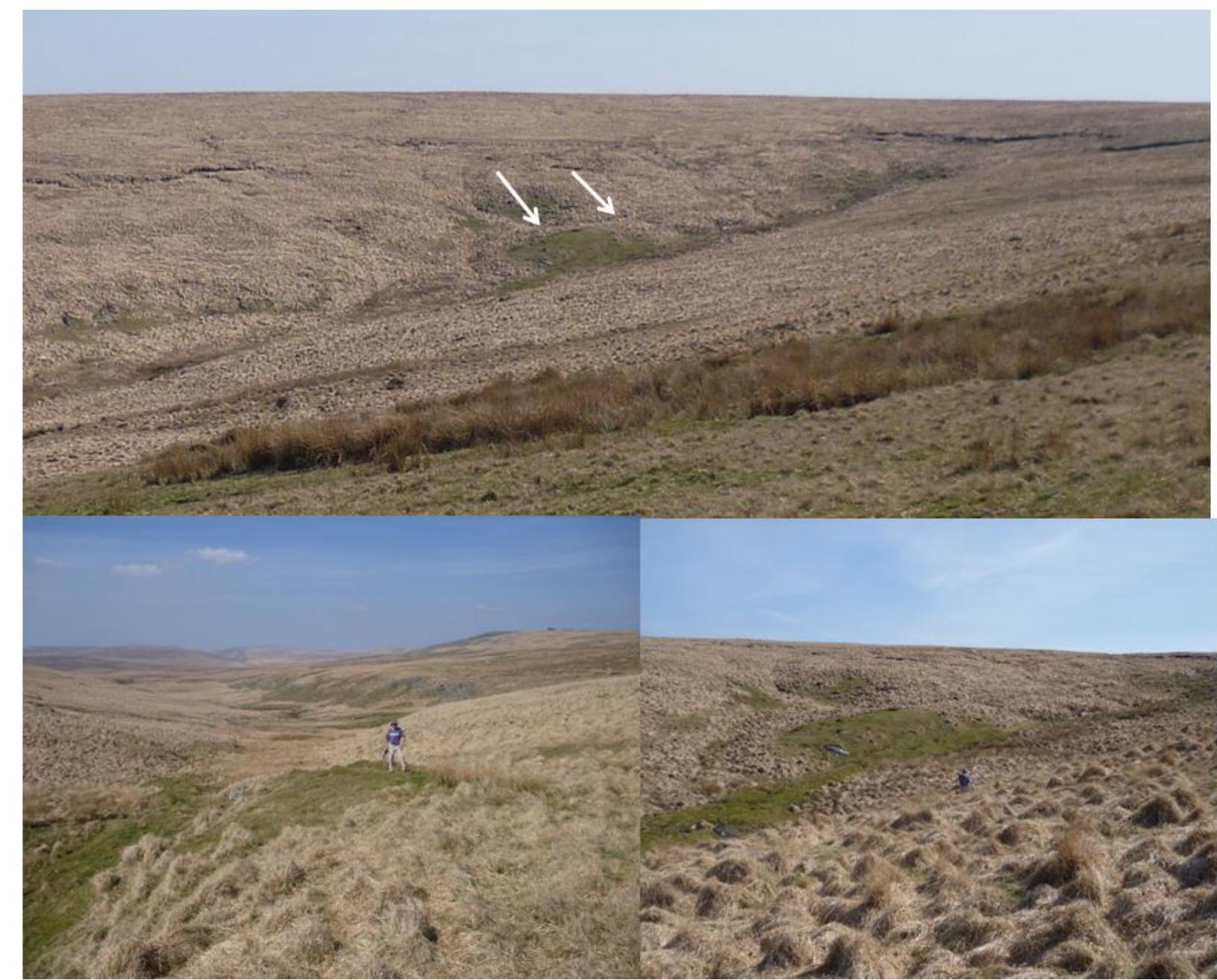
Key finding: Combining geophysical data and transient thermomechanical modeling of the Eurasian Ice Sheet over the last ~100 ka cycle, the study reveals extreme spatial and temporal variability in glacial erosion rates (0 to 5 mm a−1).... Read more
Key finding: Through detailed comparison of Quaternary glaciogenic sediments and features versus those caused by sediment gravity flows, the review identifies potential misinterpretations of pre-Pleistocene deposits. It provides a... Read more

All papers in Quaternary Glaciation

Composition and origin of petrographically-stratified thick till in the northern Netherlands and a Saalian glaciation model for the North Sea Basin. -Meded. Werkgr. Tert.
Glacial moraines in the central South Carpathian Range (Făgăraş Mountains, Romania) have been mapped in order to reconstruct the elevation of the climatic snowline (ELA) during the Last Glacial Maximum (LGM). In a representative... more
Throughout the 2.6 My of the Quaternary, Devon has occupied a critical position with respect to the evolution of Britain in that it lies close to the North Atlantic Ocean between the southern coast of the Bristol Channel and the northern... more
Theories that propose feedbacks among climate, tectonics, and surface processes commonly assume that erosion is enhanced by glacial activity. Indeed, studies have shown that glaciers appear to limit the elevation of mountain ranges;... more
This paper describes evidence for two very separate glaciations in the Kosciuszko Main Range, NSW. Australia.
Here, a charophyte assemblage from lower Pleistocene deposits at the coal mine locality of Dursunlu (Ilgın Basin, Turkey) is described and illustrated for the first time. The assemblage is composed of 11 species recovered from 50 samples... more
Relict rock glaciers are well-preserved features of high-elevated valleys in the Western Tatra Mts., Western Carpathians, but their chronology remained poorly constrained with numerical dating methods. We present the first robust set of... more
During the last glacial maximum the Cordilleran and Laurentide ice sheets coalesced east of the Rocky Mountains and geomorphological evidence indicates ice flowed over the main ridge of the Rocky Mountains between ∼54-56°N. However, this... more
This study presents a 1:25,000 geomorphological map of the northern sector of Ulu Peninsula, James Ross Island, Antarctic Peninsula. The map covers an area of c. 250 km 2 , and documents the landforms and surficial sediments of one of the... more
The combined Rhone and Aare Glaciers presumably reached their last glacial maximum (LGM) extent on the Swiss Plateau prior to 24 ka. Two well-preserved, less extensive moraine stades, the Gurten and Bern Stade, document the last... more
Despite a long history of research, the locations of former ice-margins in the North Sea Basin are still uncertain. In this study, we present new palaeogeographic reconstructions of (pre-) Elsterian and Warthian ice-margins in the... more
There are no glaciers today in the High Atlas, Morocco. However, there is evidence that niche glaciers and late-lying snowpatches in the High Atlas were present as recently as the last century and there are at least four sites where... more
Periglacial environments are characterized by cold-climate non-glacial conditions and ground freezing. The coldest periglacial environments in Pleistocene Britain were underlain by permafrost (ground that remains at or below 0°C for two... more
Fast moving palaeo-ice masses within the European Alpine Ice Cap (EAIC) during the Last Glacial Maximum within the large valleys of the European Alps are likely comparable in terms of their subglacial conditions to ice streams that... more
Exfoliation joints are well-known natural fractures limited to near the ground surface. Relatively few details, however, are known about their distribution and age in the Swiss Alps. Exfoliation joints follow the landscape surface at the... more
This is a PDF file of an article that has undergone enhancements after acceptance, such as the addition of a cover page and metadata, and formatting for readability, but it is not yet the definitive version of record. This version will... more
The Late Pleistocene Jupania palaeoglacier (area 0.85 km 2 , 1.7 km long) was reconstructed in the headwaters of the Ceremuşul Alb/Bilyj Cheremosh valley (Maramureş Mountains). The study area represents one of the most inaccessible... more
Deep, elongated incisions, often referred to as tunnel valleys, are among the most characteristic landforms of formerly glaciated terrains. It is commonly thought that tunnel valleys were formed by meltwater flowing underneath large ice... more
The combined Rhone and Aare Glaciers presumably reached their last glacial maximum (LGM) extent on the Swiss Plateau prior to 24 ka. Two well-preserved, less extensive moraine stades, the Gurten and Bern Stade, document the last... more
Reconstructions of palaeo-ice sheet retreat in response to climate warming using offshore archives can provide vital analogs for future ice-sheet behavior. At the Last Glacial Maximum, Dogger Bank, in the southern North Sea, was covered... more
This paper presents the first integrated macroscale and microscale examination of subglacial till associated with the last-glacial (Fraser Glaciation) Cordilleran Ice Sheet (CIS). A new statistical approach to quantifying till... more
Here we reconstruct the last advance to maximum limits and retreat of the Irish Sea Glacier (ISG), the only land-terminating ice lobe of the western British Irish Ice Sheet. A series of reverse bedrock slopes rendered proglacial lakes... more
The Serras of Queixa-Invernadoiro and Gerês-Xurés in the NW of the Iberian Peninsula are two small mountain massifs located at low altitude that were glaciated in the Pleistocene. The prevailing granitic lithology was a problem for... more
This study presents the first cosmogenic 36Cl surface exposure data from a moraine in the Former Yugoslav Republic of Macedonia (FYROM). Five limestone boulders from a terminal moraine in the Galicica Mountains (40.94°N, 20.83°E, 2050 m... more
The Dutch-type fine gravel analysis has been tested as a stratigraphic tool in Quaternary studies. After having obtained good results, in Hamburg and in the adjoining parts of North Germany, the author analysed some samples from Ristinge... more
In the marginal areas of the Pleistocene Scandinavian ice sheet in north Germany there are few signs of direct glacial erosion. Fine gravel analyses show that glacial reworking was not very important. This may be partly due to the fact... more
We mapped moraines and headwalls in two cirques situated below Pietrosu Peak and Răchitiş Peak. The preserved landforms suggest at least two subsequent stages of glaciations during the Late Quaternary history at both sites,... more
Be chronologies has highlighted the fact that glacial evidence previously ascribed to the Younger Dryas might be more limited than previously thought and the need for additional studies to characterized the extent of glaciers during the... more
Agriculture in the Netherlands is a major source of ammonia (NH3) emissions. Deposited nitrogen levels in the Netherlands reached 2-3 times their critical value at the start of 2020. Excess nitrogen in soil may cause declines in... more
For the Altai mountainous region, especially the arid south-eastern part, the history of glacier fluctuations in Pleistocene and Holocene is still poorly known. The key plots were located in the Kargy valley (2288-2387 m a. s. l.) that is... more
8 The granite uplands of Dartmoor have traditionally been considered to be relict permafrost and 9 periglacial landscapes that lay beyond the limits of Quaternary glaciations but a variety of landform 10 evidence indicates that a plateau... more
This article appeared in a journal published by Elsevier. The attached copy is furnished to the author for internal non-commercial research and education use, including for instruction at the authors institution and sharing with... more
During the late Saalian Drenthe glaciation ice-damming of the Upper Weser Valley led to the formation of glacial Lake Weser. The lake drained catastrophically into the Münsterland Embayment as the western ice dam failed, releasing up to... more
Be chronologies has highlighted the fact that glacial evidence previously ascribed to the Younger Dryas might be more limited than previously thought and the need for additional studies to characterized the extent of glaciers during the... more
Erosion is a fundamental player of the interactions existing between internal geodynamics and climate, in particular through its influence on the carbon dioxide budget. However, long term (>1 Ma) erosion rates, estimated indirectly from... more
This study presents the first cosmogenic 36Cl surface exposure data from a moraine in the Former Yugoslav Republic of Macedonia (FYROM). Five limestone boulders from a terminal moraine in the Galicica Mountains (40.94°N, 20.83°E, 2050 m... more
We present a new chronology to constrain ice-margin retreat in the northern Irish Sea Basin. Estimates on the timing of ice thinning derived from surface exposure ages for boulders from the summits of the Isle of Man and southwest Cumbria... more
The upper 20—30 m of ice-rich permafrost at three sites overridden by the northwest margin of the Laurentide ice sheet in the Tuktoyaktuk Coastlands, western Arctic Canada, comprise massive ice beneath ice-rich diamicton or sandy silt.... more
This study presents surface mass balance of two small glaciers on James Ross Island calculated using constant and zonally-variable conversion factors. The density of 500 and 900 kg·m–3 adopted for snow in the accumulation area and ice in... more
Nelle colline moreniche poste a nord della provincia di Mantova (anfiteatro morenico frontale del Lago di Garda), sono presenti massi erratici deposti dai ghiacciai, la cui composizione petrografica varia dai calcari, ai porfidi, ai... more
Download research papers for free!