Academia.eduAcademia.edu

Anthropogenic Sinkhole

description12 papers
group7 followers
lightbulbAbout this topic
An anthropogenic sinkhole is a depression or hole in the ground that results from human activities, such as mining, drilling, or groundwater extraction, which destabilize the subsurface and lead to the collapse of the overlying material. These sinkholes can pose significant risks to infrastructure and the environment.

Key research themes

1. How do hydrogeological and anthropogenic factors drive sinkhole formation and clustering in karst and evaporite terrains?

This theme focuses on understanding the interplay between natural geological settings—especially hydro-stratigraphy, groundwater dynamics, and rock solubility—and anthropogenic activities such as groundwater extraction, urban development, and mining, which collectively lead to sinkhole formation and aggregation. Investigations detail the mechanisms by which water chemistry, flow regimes, and human interventions modify subsurface conditions, promoting dissolution and collapse processes. This knowledge is critical for hazard assessment and mitigation in karstic and evaporite environments.

Key finding: The study links the mixing of inland freshwater with advancing brackish water in the Salento Peninsula of Italy to enhanced aggressivity (hyperkarst) causing accelerated dissolution of carbonate rocks and the formation of... Read more
Key finding: Observations reveal that rapid water table decline, largely driven by extensive groundwater pumping in the Konya Closed Basin, causes new sinkhole formation by triggering collapse of lacustrine limestone cavities in... Read more
Key finding: Comprehensive geomorphological inventory and analysis indicate a spatial zonation of sinkhole types controlled by hydrogeological functioning: solution sinkholes in recharge zones, bedrock collapse sinkholes near base level... Read more
Key finding: The study characterizes the highly karstified Miocene Fatha Formation underlying Mosul Dam, where gypsum dissolution alongside limestone karstification has created extensive solution cavities. The interbedded lithologies and... Read more
Key finding: Investigations associate sinkhole appearance near the Gun-dong limestone mine with combined factors of groundwater table lowering attributable to agricultural irrigation, mining dewatering, and urban water extraction. The... Read more

2. What modeling and geophysical approaches effectively predict sinkhole initiation, collapse mechanisms, and risk zoning?

This theme explores numerical modeling frameworks, physical and geophysical survey techniques, and machine learning methods developed to predict sinkhole formation processes, delineate prone areas, and support early warning systems. Employing limit analysis, distinct element modeling, microgravity, electrical resistivity tomography, seismic methods, and satellite-based interferometry, researchers aim to characterize subsurface voids, assess cavity stability, and produce susceptibility and risk maps. These integrated methodologies enhance hazard mitigation strategies in diverse karst environments.

Key finding: This work develops finite-element limit analysis numerical models to establish upper and lower bounds for the stability of submerged spherical cavities prone to collapse-induced sinkholes. The study advances prediction of... Read more
Key finding: By integrating 2D/3D electrical resistivity tomography, microgravity, and seismic noise measurements, this study delineates the sinkhole-prone area of "Il Piano" on Elba Island, Italy. The approach differentiates shallow... Read more
Key finding: Using 2-D distinct element method simulations, this study models subsidence processes above arrays of progressively growing subsurface cavities, reproducing sinkhole clustering and the development of larger uvala-like... Read more
Key finding: This work integrates ground-based interferometric synthetic aperture radar (GBInSAR) monitoring with a multi-criteria parametric scoring method to implement sinkhole susceptibility, vulnerability, and risk mapping in... Read more
Key finding: Deploying Maximum Entropy (MaxEnt) machine learning on a sinkhole inventory combined with lithological, hydrogeological, morphological, and InSAR-derived ground motion datasets, this study produces a sinkhole susceptibility... Read more

3. How do seismic, geomorphological, and environmental factors influence sudden sinkhole development and earth fissuring in urban and peri-urban contexts?

This theme investigates mechanisms by which seismic activity, geomorphological characteristics, and environmental stressors trigger abrupt sinkhole collapses and earth fissures, particularly in populated or infrastructure-rich areas. Research includes case studies of earthquake-induced cover collapse dolines, fissure formation related to groundwater withdrawal and soil conditions, and the impact of heavy rainfall on subterranean cavity failure. Understanding these dynamic processes informs hazard mitigation, emergency planning, and infrastructure resilience in vulnerable urban landscapes.

Key finding: Following December 2020–March 2021 earthquakes near Petrinja, Croatia, new dropout dolines developed rapidly in covered karst along fault zones characterized by low bearing surface inclinations and groundwater fluctuations.... Read more
Key finding: This study proposes that synergetic processes including excessive groundwater withdrawal, soil friability, pre-existing fractures, and subsurface lithology underlie the pervasive earth fissuring in Najran, Saudi Arabia. While... Read more
Key finding: This case study of the 2008 El Trebol sinkhole in Quito attributes the sudden large-scale collapse to blockage and degradation of an old subterranean concrete box tunnel rerouting the Machángara river, compounded by heavy... Read more

All papers in Anthropogenic Sinkhole

Soft highly porous carbonate rocks such, as calcarenites, and soluble sulphate rocks, as gypsum, are very common in the Mediterranean region and, due to their microstructure and chemical composition, are prone to water induced weathering... more
Risk perception is judgment that people make about the characteristics and severity of risks, in last few years risk perception studies focused on provide cognitive elements to communication experts responsible in order to design... more
The extraction of ore and minerals by underground mining often causes ground subsidence phenomena and may result in severe damage to buildings. Risk analysis in subsidence regions requires the assessment of both the hazards to and... more
In Campania (southern Italy), the widespread presence of anthropogenic cavities in the subsoil of the Neapolitan and Caserta provinces is well known. In these towns, the underground quarrying activities were performed for centuries to... more
Your article is protected by copyright and all rights are held exclusively by Springer-Verlag Wien. This e-offprint is for personal use only and shall not be self-archived in electronic repositories. If you wish to self-archive your... more
Within the PanGeo project (financed by the European Commission under the 7th Framework Program), the Geological Survey of Italy (ISPRA) and the Urban Planning Department of the City of Roma developed a geodatabase and map of the... more
by Yeasin Arafat and 
1 more
Geological phenomena vary in space and time, a trait that makes geology a very suitable application field for Geographical Information Systems and science (GIS). A GIS is a computer-based tool for the mapping, display and analysis of... more
Ancient mining and quarrying activities left anthropogenic geomorphologies that have shaped the natural landscape and affected environmental equilibria. The artificial structures and their related effects on the surrounding environment... more
In Campania (southern Italy), the widespread presence of anthropogenic cavities in the subsoil of the Neapolitan and Caserta provinces is well known. In these towns, the underground quarrying activities were performed for centuries to... more
This study aims to investigate an unpublished case of a large complex of quarries in Polignano a Mare (southern Italy), a few metres from the coast of the Adriatic Sea, which was in use until the middle of the 20th century and is now... more
Many built-up areas of Sicily (southern Italy) are affected by such type of risk. In particular, Marsala (western end of Sicily, Figure 1) was affected in the past decades by several collapse phenomena which caused extensive damage to... more
Sinkhole development occurs in many areas of the world where soluble rocks crop out. Sinkholes are generally the surface expression of the presence of caves and other groundwater flow conduits in carbonate rocks, which are solutionally... more
The UK is perhaps unique globally in that it presents the full spectrum of geological time, stratigraphy and associated lithologies within its boundaries. With this wide range of geological assemblages comes a wide range of geological... more
Many large collapses have occurred during or after underground quarry operations. The collapse of the Clamart underground quarry (in 1961, South of Paris-France) is well known as one of the most catastrophic. This paper presents a... more
This work presents a sinkhole susceptibility and risk assessment mapping in Guidonia-Bagni di Tivoli plain (Italy), a travertine sinkhole-prone area where sudden occurrences of sinkholes have happened in past and recent times. We... more
All activities used to identify the underground quarries, recognize the corresponding sinkhole-prone areas at the surface, survey the cavities, produce detailed maps, and reclaim the sites in order to allow future development, are... more
Sinkhole development occurs in many areas of the world where soluble rocks crop out. Sinkholes are generally the surface expression of the presence of caves and other groundwater flow conduits in carbonate rocks, which are solutionally... more
Internal degradation induced in the metropolitan areas by leakage of sewers. As the resistance to erosion depends on the distribution of soil particles and the water pressure in sewer pipes, it is worthwhile to research the impact of... more
This work presents a sinkhole susceptibility and risk assessment mapping in Guidonia-Bagni di Tivoli plain (Italy), a travertine sinkhole-prone area where sudden occurrences of sinkholes have happened in past and recent times. We... more
The underground exploitation of calcarenitic rocks, it's not uncommon especially in cases where the calcarenites doesn't outcrop. This activity caused evident phenomena of subsidence in surface with damages to the belongings and... more
The extraction of ore and minerals by underground mining often causes ground subsidence phenomena and may result in severe damage to buildings. Risk analysis in subsidence regions requires the assessment of both the hazards to and... more
A reply essay is presented on the rebuttal article by Parise (Environ Earth Sci 75(23):1476, 2016) suggesting that qanat is not a hazard. It is presented as a refutation on the paper by Abbasnejad et al. (Environ Earth Sci 75:1306, 2016)... more
All activities used to identify the underground quarries, recognize the corresponding sinkhole-prone areas at the surface, survey the cavities, produce detailed maps, and reclaim the sites in order to allow future development, are... more
The underground exploitation of calcarenitic rocks, it's not uncommon especially in cases where the calcarenites doesn't outcrop. This activity caused evident phenomena of subsidence in surface with damages to the belongings and... more
Historical records were used for the compilation of a database of sinkholes resulted from collapses of abandoned shallow underground limestone quarries (mines) in two villages in Belgian South Limburg. During the last 350 years the... more
This GeoHazard Description (GHD) was prepared by the Italian Geological Survey, a department of the Italian Institute for Environmental Protection and Research (ISPRA), and acts as support for the PanGeo Ground Stability Layer (GSL) of... more
It has been said that Palermo is short of available water. However, nothing could be more wrong. Well-documented Arab sources and narrative chronicles reported an abundance of groundwater resources in Palermo Plain since the Middle Ages.... more
Abstract: It has been said that Palermo is short of available water. However, nothing could be more wrong. Well-documented Arab sources and narrative chronicles reported an abundance of groundwater resources in Palermo Plain since the... more
The rising groundwater levels in Ajdabiya city have been considered one of the critical issues that the city suffered for years, where it is attributed to a lot of undesirable environmental and physical effects. Deterioration of... more
Urban geological hazards involving ground instability can be costly, dangerous, and affect many people, yet there is little information about the extent or distribution of geohazards within Europe's urban areas. A reason for this is the... more
The Upper City of Antananarivo, is one of the districts of the capital of Madagascar subject to the regulations of the Architectural, Urban and Landscape Heritage Protection Zone [1]. On the other hand, the urbanization of this zone has... more
Classical rock mass classification systems are not applicable to carbonate rocks, especially when these are affected by karst processes. Their applications to such settings could therefore result in outcomes not representative of the real... more
Sinkhole development occurs in many areas of the world where soluble rocks crop out. Sinkholes are generally the surface expression of the presence of caves and other groundwater flow conduits in carbonate rocks, which are solutionally... more
All activities used to identify the underground quarries, recognize the corresponding sinkhole-prone areas at the surface, survey the cavities, produce detailed maps, and reclaim the sites in order to allow future development, are... more
Underground voids of natural or anthropogenic origin potentially represent a serious hazard to the built-up areas. Urban development and construction of infrastructures often is carried out without taking into account the possibility of... more
Natural or man-made underground caves potentially represent a serious hazard to the built-up areas. Urban development and construction of infrastructures is generally carried out without taking into account the possibility of interacting... more
It has been said that Palermo is short of available water. However, nothing could be more wrong. Well-documented Arab sources and narrative chronicles reported an abundance of groundwater resources in Palermo Plain since the Middle Ages.... more
The use of general descriptive names, registered names, trademarks, service marks, etc. in this publication does not imply, even in the absence of a specific statement, that such names are exempt from the relevant protective laws and... more
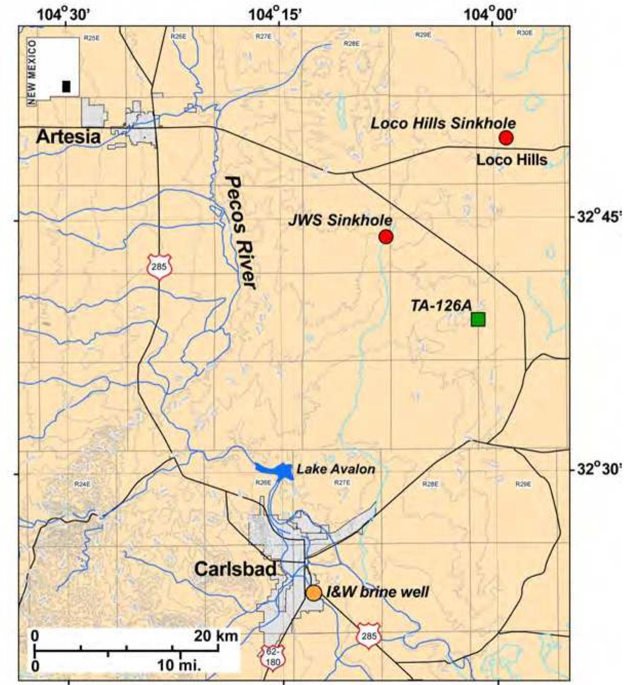
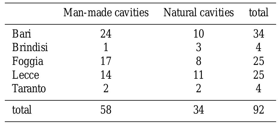
Sinkholes of both natural or anthropogenic origin are widespread phenomena in Italy, and locally constitute the main hazard. Notwithstanding the potential threat they represent to the built-up environment, sinkholes are rarely considered... more
Within the PanGeo project that aims at Enabling Access to Geological Information in Support to GMES (now Copernicus) services, the Geological Survey of Italy, together with the Urban Planning Department of Roma Capitale, have elaborated a... more
RIASSUNTO-I sinkholes antropogenici nel territorio di Roma Capitale sono strettamente connessi alla rete di cavità sotterranee prodotta dalle attività umane (reti idrauliche, cave, catacombe etc.) che si sono svolte in più di duemila anni... more
Abstract: It has been said that Palermo is short of available water. However, nothing could be more wrong. Well-documented Arab sources and narrative chronicles reported an abundance of groundwater resources in Palermo Plain since the... more
Geospatial technology (that includes Remote Sensing and Geographical Information System GIS) has opened up opportunities for qualitative analyses of sinkholes distribution with multi thematic maps to define the relationship of GIS... more
Download research papers for free!